 |
Southern African
topography and erosion history:
plumes or plate tectonics? |
Andy Moore1,2, Tom Blenkinsop3 & Fenton
(Woody) Cotterill4
1African Queen Mines Ltd., Box 66, Maun Botswana.
2Dept
of Geology, Rhodes University, Grahamstown, South Africa, andy.moore@info.bw
3School
of Earth and Environmental Sciences, James Cook University,
Townsville, QLD4811, Australia, thomas.blenkinsop@jcu.edu.au
4AEON
- Africa Earth Observatory Network, and Department
of Geological Sciences, and Department of Molecular
and Cell Biology, University of Cape Town, Rondebosch
7701, South Africa, fcotterill@gmail.com
This webpage is a summary of: Moore,
A., Blenkinsop, T. & Cotterill, F. Southern African
topography and erosion history: plumes or plate tectonics?,
Terra Nova, 21, 310-315,
2009.
ABSTRACT
The physiography of southern Africa
comprises a narrow coastal plain, separated from an
inland plateau by a horseshoe-shaped escarpment. The
interior of the inland plateau is a sedimentary basin.
The drainage network of southern Africa is characterized
by three river divides, broadly parallel to the coastline.
These features contrast strongly with the broad dome
and radial drainage patterns predicted by models which
ascribe the physiography of southern Africa to uplift
over a deep mantle plume. The drainage divides are
interpreted as axes of epeirogenic uplift. The
ages of these axes, which young from the margin to
the interior, correlate closely with major reorganizations
of spreading regimes in the oceanic ridges surrounding
southern Africa, suggesting an origin from stresses
related to plate motion. Successive uplifts
of southern Africa were focused along respective
epeirogenic axes, forming the major river divides.
These events initiated cyclic episodes of denudation,
which are coeval with erosion surfaces recognized elsewhere
across Africa.
The interior of southern
Africa forms part of a belt of elevated ground,
extending to East Africa, termed the “African
Superswell” (Nyblade
& Robinson, 1994), which is anomalously
high (>1000 m)
relative to average elevations of 400-500m for cratonic
areas on other continents (Lithgow-Bertelloni
& Silver, 1998; Gurnis
et al., 2000). The
latter two studies conclude, on the basis of theoretical
geophysical modelling, that the anomalous elevation
of southern Africa is related to the dynamic effects
of the extant “African Superplume”.
Their models predict that the plume-sustained topography
of southern Africa will approximate to a broad dome,
with an implied radial drainage pattern. However,
this is completely at odds with the observed first-order
topography, with the interior of the country being
the site of the relatively low-lying Kalahari sedimentary
basin, surrounded by a horseshoe arc of high ground
that is closely associated with the marginal escarpment
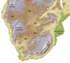
(Figure 1). Moreover, the drainage system
of southern Africa defines a remarkable pattern of
three concentric river divides, broadly parallel
to the continental margin (Figure 2), and completely
at odds with the radial drainage pattern implied
by the plume model.
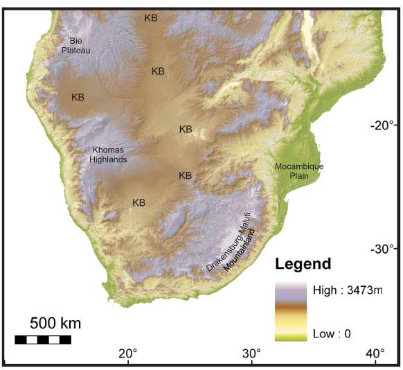
Figure 1: SRTM digital elevation image
for southern Africa. The highest elevations
(purple-grey tones) are associated with the marginal
escarpment and the central Zimbabwe watershed.
This high ground surrounds the Cenozoic Kalahari sediments,
whose extent is depicted by dotted line. Elevations
in meters.
Figure 2. Drainage system of southern
Africa. Colours denote stream rank from red (1) to
purple (5). M = Molopo River, N = Nossob River, MM
= Mahura Muhtla. The major river divides are interpreted
to reflect epeirogenic uplift Axes. EGT Axis = Etosha-Griqualand-Transvaal
Axis; OKZ Axis = Ovambo-Kalahari-Zimbabwe Axes. Data
from USGS
EROS.
The three major river divides in southern
Africa cut across boundaries between Archaean cratons
and surrounding Proterozoic mobile belts, as well as
other major structural features such as the Great Dyke
(Zimbabwe), Okavango Dyke Swarm (Botswana) and late-Proterozoic
Damara belt (Namibia) (Figure 3). This argues against
a primary lithological control, and they have been
interpreted rather as axes of epeirogenic flexure (du
Toit,
1933; King, 1963; Moore,
1999). They are designated, from the coast inlands,
the Escarpment Axis, Etosha-Griqualand-Transvaal (EGT)
Axis and Ovambo-Kalahari-Zimbabwe (OKZ) Axis respectively
(Figure 2). The EGT and OKZ axes are closely associated
with the margins of the Kalahari basin (Figure 4),
indicating that the latter was controlled by uplift
along these two flexures (du Toit,
1933).
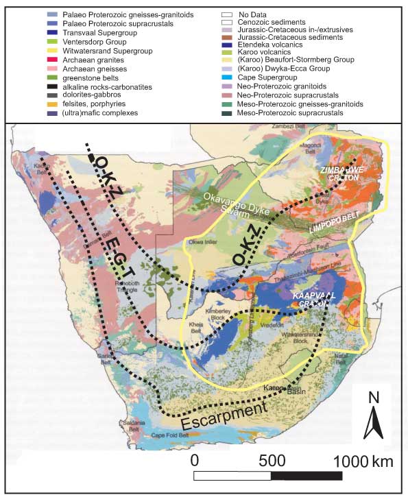
Figure 3. Loci of major river divides,
inferred to reflect axes of epeirogenic flexure, in
relation to the geology of southern Africa. These divides
all cross boundaries separating Archaean cratons from
the surrounding Proterozoic terrains. In Namibia, they
traverse the northeast-trending late Proterozoic Damara
belt at a high angle. In Zimbabwe, the O-K-Z axis transects
the granite-greenstone terrain of the Zimbabwe craton,
cuts across the NNE-trending Great Dyke, and continues
across the Okavango Dyke swarm in Botswana. The central
E-G-T axis crosses the north-trending Kheiss belt at
right angles, while much of the eastern section of
the Escarpment axis traverses readily eroded horizontal
Karoo sediments. Geology of southern Africa after De
Wit et al. (2004).
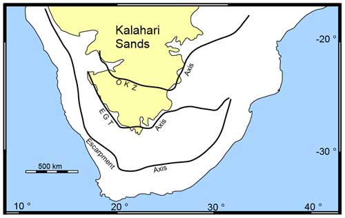
Figure 4. Distribution of the Kalahari
Formation (Kalahari Sands) in relation to the epeirogenic
axes defined by the major river divides. Note how the
EGT Axis encircles the southern margin of the Kalahari
basin. Further to the north, the eastern and western
margins of the basin are bounded by the OKZ Axis.
Independent geological evidence and
apatite fission track (AFT) dating, summarized in the
original paper by Moore et al. (2009), shows that the
three axes represented by the major river divides are of
different ages (Escarpment: early Cretaceous; EGT:
Upper-Cretaceous to early Palaeogene; OKZ: late Palaeogene
respectively), and thus young from the coast towards
the interior. Their ages in turn correspond closely
with major reorganizations of the spreading ridges
surrounding Africa (Figure 5). Thus, initiation of
the Early Cretaceous Escarpment Axis matches the opening
of the Atlantic and Indian at ~126 Ma (McMillan,
2003). The age of the EGT Axis corresponds closely
with major changes of the Atlantic and Indian ridge
spreading poles at ~84 and ~90 Ma respectively (Nürnberg
& Müller, 1991; Reeves
& de Wit, 2000). The late Palaeogene OKZ
axis is broadly coeval with a major spreading reorganization
in the Indian Ocean (Reeves &
de Wit, 2000) as well
as a marked increase in spreading rate at the Mid-Atlantic
Ridge (Nürnberg & Müller, 1991;
Figure 5). These temporal correlations, coupled with
the broad parallelism of the concentric river divides
and the oceanic spreading ridges surrounding southern
Africa, suggests that uplift along the continental
flexures was linked to deformation events associated
with plate reorganization. This implies long-range
transmission of stresses, through the lithosphere,
from the ridges into the continental interiors.

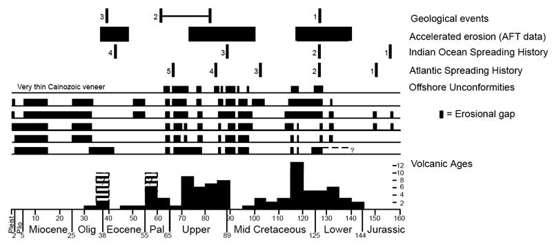
Figure 5. Comparison of the geological
events that constrain the ages of uplift axes, Indian
and Atlantic Ocean opening histories, offshore basin
erosion histories and ages of alkaline volcanic rocks
(based on Moore et al., 2008). Geologic events are:
1 – Start of Atlantic opening (McMillan, 2003);
2 – Maximum/minimum age bracket for disruption
of Mahura Muthla paleo-drainage (Partridge, 1998);
3 – Increased
sedimentation in the major Zambezi and Limpopo River
deltas (Walford et al., 2005; Burke & Gunnell,
2008). Offshore unconformities data are from McMillan,
(2003) within the Kwa Zulu, Algoa, Gamtoos, Pietmos,
Bredasdorp, and Orange basins respectively (from top
to bottom). Indian Spreading History from McMillan
(2003) and Reeves
& de Wit (2000): 1 – Initial rifting between
Africa and Antarctica; 2 – Commencement of spreading;
3 & 4: Changes in Indian Spreading regime recognized
by Reeves & de Wit (2000). Atlantic Spreading History
(from Nürenberg & Muller, 1991; Dingle & Scrutton,
1974): 1- Rifting extends into southern Atlantic Ocean;
2 – Commencement of opening of Atlantic (drift
sequence); 3: Estimated time of separation of Falkland
Plateau and Agulhas bank, based on assumed spreading
rates; 4 – Major shift in pole of rotation of
African/South American plates; 5 – Beginning
of progressive shift in pole of rotation of African/South
American plates. Sources of volcanic ages are quoted
in Table 1 of Moore et al. (2008). Dashed lines and
question marks are for the Chameis Bay pipes, denoting
the two different ages indicated by field relationships
and very limited radiometric dating. Click here or on image for enlargement.
The three ages of epeirogenic flexure
that initiated the major river divides are all broadly
contemporaneous with episodes of alkaline volcanism
in southern Africa. However, while the axes young from
the coast towards the interior, volcanic activity migrated
in the reverse sense, from the interior towards the
coastal margins. This inverse relationship is not readily
explained by the plume hypothesis, and we conclude
that volcanic activity was triggered by lithospheric
stresses. In concordance with the mechanisms proposed
by Oxburgh & Turcotte (1974), the broad upwarps represented
by the flexure axes would be associated with relative
tensional stresses in the upper surface of
the plate. In contrast, the lower plate
surface would experience relative tension beneath the
basins surrounding the axes.
Our observations have an important
bearing on one of the most celebrated debates in geomorphology.
This is the concept of erosion cycles, championed
by Lester King in papers published in 1949, 1955 and
1963, who recognized relics of successive erosion
surfaces of different ages in southern Africa, including
the African Surface of continent-wide distribution.
Many of the criticisms of this model focussed on the
underlying model to account for these surfaces, rather
than the evidence for their existence. Successive uplifts
along the axes represented by the major river divides
would each result in episodes of drainage rejuvenation,
thus initiating a new cycle of erosion. This provides
a series of triggers that could account for the development
of erosion surfaces of different ages. The
ages of the axes correspond also closely in age to
major unconformities recognized in the Congo basin
(Cahen & Lepersonne, 1952; Girisse,
2005; Stankiewicz & de Wit, 2006), pointing to continent-wide
episodes of erosion, as postulated by King (1963).
Acknowledgments
We thank Tyrel Flugel for producing
the Digital Elevation image of southern Africa, and
Dr. Marty McFarlane, Paul Green and two anonymous reviewers
for their constructive comments on the manuscript that
formed the basis for this web page.
References
-
Anderson, D.L. and Natland,
J.H., 2005. A brief
history of the plume hypothesis and its competitors:
concept and controversy. Geol. Soc.
Amer. Spec. Paper, 238,
119-145.
-
Anderson,
D.L. and Natland, J.H., 2006. Evidence
for mantle plumes? Nature, 450,
E15.
-
Bailey, D.K., 1993. Petrogenic
implications of the timing of alkaline, carbonatite
and kimberlite igneous activity in Africa. S.
Afr. J. Geol., 96,
67-74.
-
Belton, D.X., 2006. The low temperature
chronology of cratonic terrains. Ph.D.
Thesis, unpublished, University of Melbourne, Australia,
306 pp.
-
Bond G., (1979). Evidence
for some uplifts of large magnitude in continental
platforms. Tectonophysics, 61,
28-305.
-
Brown, R.W., Gallagher, K., Gleadow, A.J.W.
and Summerfield, M.A., 1999. Morphotectonic evolution
of the south Atlantic margins of Africa and South
America. In: Summerfield, M.A. (ed.) Geomorphology and Global
Tectonics.
John Wiley, 255-283.
-
Brown, R.W., Rust, D.J., Summerfield,
M.A., Gleadow, A.J.W. and de Wit, M.C.J., 1990. An
accelerated phase of denudation in the south-western
margin of Africa: evidence from apatite fission
track analysis and the offshore sedimentary record. Nucl.
Tracks. Rad. Measur., 17,
339-350.
-
Brown,
R.W., Summerfield, M.A. and Gleadow, A.J.W., 2002.
Denudational history along a transect across the
Drakensberg Escarpment of southern Africa derived
from apatite fission track thermochronology. J.
Geoph. Res., 107, (B12) 2350,
doi:10.1029/2001JB000745.
-
Burke, K., 1996. The African
Plate. S. Afr. J. Geol., 99,
339-409.
-
Burke, K. and Gunnell, Y. 2008.
The African Erosion Surface: a continental-scale
synthesis of geomorphology, tectonics, and environmental
change over the past 180 million years. Geol. Soc.
Amer. Mem., 201,
1-66.
-
Burke, K., Steinberger, B.,
Torsvik, T.T. and Smethurst, M.A. 2008. Plume Generation
Zones at the margins of Large Low Shear Velocity
Provinces on the core–mantle
boundary. Earth Planet. Sci. Lett., 286, 49-60.
-
Cahen,
L. and Lepersonne, J., 1952. Équivalence
entre le Système du Kalahari du Congo belge
et les Kalahari beds d’Afrique australe. Mém.
belge Géol., Pal., Hydrol., Soc.
Série
in -8o 4, 63 pp.
- De Wit, M.J., Richardson, S.H. and Ashwal, L.D.
(2004). Kaapvaal Craton special volume – an
introduction. South African Journal of Geology,
2004, 1-6.
-
-
Ebinger, C.J. and
Sleep, N.H., 1998. Cenozoic
magmatism throughout east Africa resulting from
impact of a single plume. Nature, 395,
788-791.
-
Fleming, A., Summerfield, M.A.,
Stone, J.O., Fifield, L.K. and Cresswell, R.G., 1999. Denudation
rates for the southern Drakensberg escarpment,
SE Africa, derived from in-situ produced
cosmogenic 36Cl: initial results. J. Geol. Soc. London,
156, 209-212.
-
Fleming, I. (1959). Goldfinger.
Cape, London, 318 pp
-
Foulger, G., 2007. The “plate” model
for the genesis of melting anomalies. Geol. Soc.
Amer. Spec. Paper 430,
1–28.
-
Gilchrist,
A.R. and Summerfield, M.A., 1991. Denudation, isostacy
and landscape evolution. Earth Surface
Processes and Landforms, 16,
555-562.
- Giresse, P., 2005. Mesozoic-Cenozoic history of
the Congo Basin. J. Afr. Earth Sci., 43,
301-315.`
-
Gurnis, M., Mitrovica, J.X.,
Ritsema, J. and van Heijst, H-J., 2000. Constraining
mantle density structure using geological evidence
of surface uplift rates: the case of the African
superplume. Geochemistry,
Geophysics, Geosystems, 1,
1-44.
-
Haddon,
I.G. (1999). Isopach Map of the Kalahari
Group, 1:2 500 000. Council for Geoscience,
South Africa.
-
Haddon, I.G. (2001). Sub-Kalahari
Geological Map, 1:2 500 000. Council
for Geoscience, South Africa.
-
Hillis, R.R., Holford,
S.P., Green, P.F., Dorž, A.G., Gatliff, R.W., Stoker,
M.S.,Thomson, K., Turner, J.P., Underhill, J.R.,
and Williams, G.A., 2008, Cenozoic exhumation of
the southern British Isles: Geology, 36, 371-374.
-
Holford,
S.P., Green, P.F., Duddy, I.R., Turner, J.P., Hillis,
R.J. and Stoker, M.S., 2009. Regional
intraplate exhumation episodes related to plate
boundary deformations. Geol.
Soc. Amer. Bull. (in
press).
-
King,
L.C., 1949. On the ages of African land-surfaces. Quarterly
Journal of the Geological Society, 104,
439-459.
-
King, L.C., 1955. Pediplanation
and isostasy: an example from South Africa. Quarterly Journal
of the Geological Society, 111,
535-539.
-
King, L.A., 1963. The South
African Scenery.
Oliver and Boyd, London, United Kingdom, 308 pp.
-
Lister,
L.A. 1987. The erosion surfaces of Zimbabwe. Bull. Zim.
Geol. Survey 90, 163 pp.
-
Lithgow-Bertelloni
and Silver, P., 1998. Dynamic topography, plate
driving forces and the African superswell. Nature,
395, 269-272.
-
McMillan, I.K., 2003. Foraminiferally
defined biostratigraphic episodes and sedimentary
patterns of the Cretaceous drift succession (Early
Barremian to Late Maastrichtian in seven basins
on the South African and southern Namibian continental
margin. S.
Afr. J. Sci., 99, 537-576.
-
-
Moore, A.E. and Blenkinsop,
T.G., 2006. Scarp retreat versus pinned drainage
divide in the formation of the Drakensberg escarpment,
southern Africa. S.
Afr. J. Geol., 109, 455-456.
-
Moore, A.E.,
Blenkinsop, T.G. and Cotterill, F.P.D., 2008. Controls
of post-Gondwana alkaline volcanism in southern
Africa. Earth
Planet. Sci. Lett., 268,
151-164.
-
Moore,
A.E., Cotterill, F.P.D., Broderick, T.G. and
Plowes, D. 2009. Landscape evolution in Zimbabwe
from the Permian to present, with implications
for kimberlite prospecting, S.
Afr. J. Geol.,
112, 65-86.
-
Moore, A.E. and Moore, J.M.,
2006. A
glacial ancestry for the Somabula diamond-bearing
alluvial deposit, central Zimbabwe. S. Afr.
J. Geol.,
109, 471-482.
-
Nyblade, A.A. and Robinson,
S.W., 1994. The African superswell. Geophys.
Res. Lett., 21,
765-768.
-
Nürnberg, D. and Müller, R.D., 1991. The
tectonic evolution of the south Atlantic from Late
Jurassic to present. Tectonophysics, 191,
27-53.
-
Oxburgh, E.R. and Turcotte,
D.L. 1974. Membrane tectonics and the East African
Rift. Earth
Planet. Sci. Lett. 22, 133-140.
-
Partridge,
T.C., 1998. Of diamonds, dinosaurs
and diastrophism: 150 million years of landscape
evolution in southern Africa. S. Afr. J. Geol., 101,
165-184.
-
Partridge, T.C and Maud, R.R.,
1987. Geomorphic evolution of southern Africa since
the Mesozoic. S.
Afr. J. Geol., 90,
165-184.
-
Reeves,
C. and de Wit, M.J., 2000. Making ends
meet in Gondwana: retracing the transforms of the
Indian Ocean and reconnecting the continental shear
zones. Terra
Nova, 12, 272-280.
-
Stankiewicz,
J. and de Wit, M.J., 2006. A proposed drainage
evolution model for Central Africa - Did the Congo
flow east? J.
Afr. Earth Sci., 44, 75-84.
-
Tinker,
J., de Wit, M. and Brown, R. 2008. Mesozoic exhumation
of the southern Cape, South Africa, quantified
using apatite fission tract thermochronology. Tectonophysics, 455, 77-93.
-
Torsvik,
T.H., Smethurst, M.A., Burke, K., and Steinberger,
B., 2006. Large igneous provinces generated from
the margins of the large low-velocity provinces
in the deep mantle. Geophys.
J. Int., 167,
1447–1460.
-
Walford, H.L., White, N.J. and
Sydow, J.C., 2005. Solid
sediment load history of the Zambezi Delta. Earth
Planet. Sci. Lett., 238,
49-63.
-
Westaway,
R., Bridgland, D., and S. Mishra, S.,
2003. Rheological differences between Archaean
and younger crust can determine rates of Quaternary
vertical motions revealed by fluvial geomorphology. Terra
Nova, 15, 287–298.
last updated 14th
April, 2010 |