 |
Influence
of pre-salt alignments in the post-Aptian magmatism
in the Cabo Frio High and its surroundings, Santos
and Campos Basins, SE Brazil: an example of non-plume-related
magmatism. |
| Sérgio
Goulart Oreiroa, José Antônio
Cupertinob, Peter Szatmaric
& Antônio Thomaz Filhod
aPetrobras,
E&P/EXP, Av República do Chile, 65,
Centro, Rio de Janeiro, RJ, sala 1301, oreiro@petrobras.com.br
Tel: 55 21 32244704
bPetrobras,
E&P/EXP, Av. República do Chile, 65,
Centro, Rio de Janeiro, RJ, sala 1302, jacgeo@petrobras.com.br
cPetrobras,
CENPES/PDEXP/GEOF, Av. 1, quadra 7, Cidade Universitária,
Ilha do Fundão, Rio de Janeiro, RJ, szatmari@petrobras.com.br
dUERJ,
Rua São Francisco Xavier, 524 Maracanã,
Rio de Janeiro, RJ- Bloco 'A' - Sala 4030, thomaz@uerj.br |
 Click here to
download a PDF version of this webpage Click here to
download a PDF version of this webpage
Abstract
This study of the
Late Cretaceous and Early Tertiary magmatism in the
offshore Cabo Frio area, at the border between the Santos
and Campos Basins, SE Brazil, is based 2D and 3D seismic
lines processed using amplitude Volume of Amplitudes
(VA) and onshore mapping and offshore well data. The
data suggest interpretations regarding genesis of this
magmatism which do not follow the classic mantle plume
model. Mapping the main feeder dikes in reflection seismic
sections has revealed that they have a predominant SE-NW
orientation, coincident with the alignment of the Cruzeiro
do Sul Deformation Zone, which includes the Cabo Frio
High. This fits with major preexisting and reactivated
SW-NE trending transfer faults on land. Moreover, the
largest volumes of magmatic rocks offshore, which are
intercalated in the sedimentary section, occur at the
intersections of two fault zones with orientations SE-NW
(transfer faults) and SW-NE (normal faults), similar
to the onshore alkaline bodies of the Poços de
Caldas – Cabo Frio alignment. These data point
to a non-plume origin for this magmatism because the
reactivated faults (mainly the SE-NW transfer faults)
appear to have cut through the whole lithosphere, reaching
the asthenosphere, and thus, causing partial melting
by simple pressure release.
This webpage is a summary
of work by Oreiro et al. (2005), submitted
to the Journal of South American Earth Sciences.
1.
Introduction
The purpose of this webpage is to present a brief summary
of what is presently known about post-Aptian (Aptian
corresponds to 125-112 Ma) magmatism in the Cabo Frio
High area and its surroundings, as well as to present
new interpretations for the genesis of this magmatism.
The Aptian is the time of deposition of the salt sequence
in the region. The study area is shown in Figure 1.
The methodology was based on interpretation of 3D seismic
data, correlated with well logs, and study of cuttings
and cores of wells that drilled magmatic rocks in and
around the area.

Figure 1: Onshore geologic
map of SE Brazil (CPRM 2000, CD-Rom) combined with the
offshore Bouguer gravimetric map (from the webpage of
University of California, San Diego), depicting the
Cretaceous hinge line (in black) and the present shelf
break (in white). (1) the Brusque Group, (2) the Paranaguá
Terrain and (3) the metasedimentary rocks of the Cabo
Frio Terrain. (Modified after Zalán & Oliveira,
2005).
Almeida (1991)
suggested that both the Brazilian volcanic islands and
seamounts of the Abrolhos Volcanic Complex/Vitória-Trindade
Fracture Zone and the magmatic alignment of Poços
de Caldas (82 Ma, Ar/Ar - Cabo Frio, 53 Ma, Ar/Ar; Figure
8) are located over vast fracture zones. Magma ascended
during reactivation of deep fault zones. On the other
hand, several authors attribute such alignments to mantle
plumes and hotspots (e.g., Sadowsky & Dias Neto,
1981; Herz, 1987; Thompson et al.,
1998; Szatmari et al., 2000; Thomaz Filho
et al., 2005). Alves
et al.
(2005) interpreted both normal and strike-slip faults
along the Vitória-Trindade Fracture Zone (Figures
1 and 9) and concluded that this zone acts as a conduit
for the Trindade mantle plume. The authors of the present
webpage agree that the faults shown by Alves
et al.
(2005) are deep structures that reached the asthenospheric
mantle and caused partial melting by simple pressure
release.
The mantle plume model
is now widely questioned. The main purpose of this webpage
is to present unpublished data that may provide new
insights to that debate and also enrich interpretations
of the magmatism that occurs in southeast Brazil. The
data presented here favour a non-plume origin for this
magmatism.
2.
Characteristics of the volcanic bodies in the study
area
The magmatic rocks at
the base of the Tertiary (Paleocene and Eocene) mainly
arose from a central conduit system with volcanic edifices
of conic form with a chaotic seismofacies in their inner
part. A seismofacies may be defined as the set of characteristics
of the seismic reflections, including amplitudes, frequencies
and continuity. The base of the volcanoes is normally
shown by a strong positive reflection, interpreted by
Oreiro (2002) as related to the seafloor at
the time of formation of these edifices (Figure 2).
All the wells drilled into these volcanic edifices up
to now, in the Santos and the Campos basins, have sampled
hyaloclastites and volcaniclastic rocks.
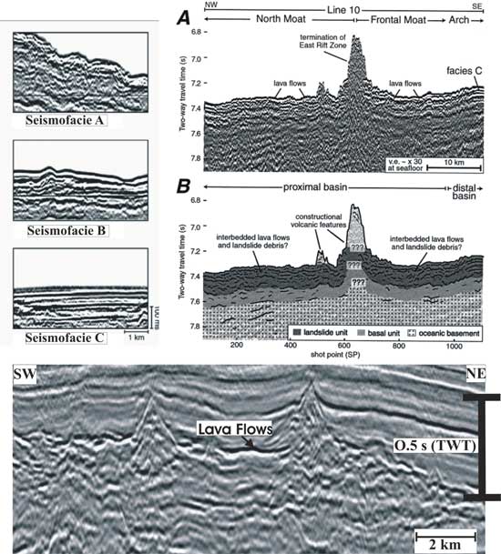
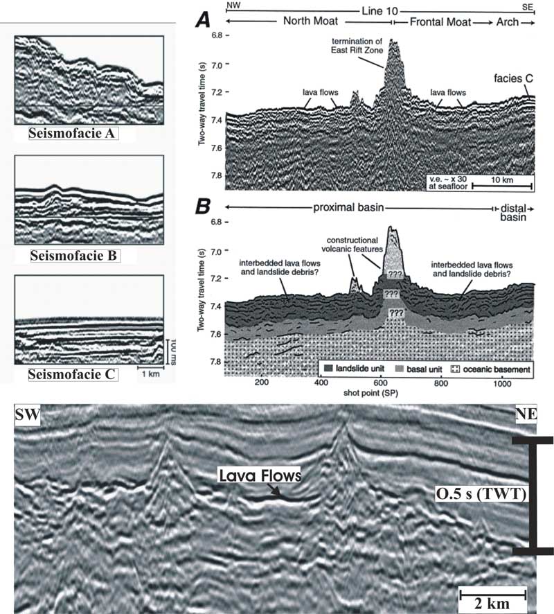
Figure 2: Comparison
between the seismofacies defined in offshore Hawaii
by Leslie et al. (2002) and the seismostratigraphic
aspects of the magmatic section in the Cabo Frio Area.
In the upper left, the seismofacies A is interpreted
as corresponding to proximal slumps originating from
the volcanic edifices; the seismofacies B to distal
slumps; the seismofacies C to volcaniclastic turbidites.
In the upper right, is a seismic section (A) and its
interpretation (B). The actual seafloor is made of lava
flows, and the chaotic seismofacies represents intercalations
between older lava flows and volcaniclastic sediments
originating from the cones. In the lower panel, a 2D
seismic section from the Cabo Frio area is shown, in
which it is clear that the seismofacies situated near
the cones is similar to the seismofacies A of Leslie
et al. (2002), indicating that both were formed by the
same process (slumping). The strong positive reflections,
adjacent to the cones, are the seismic signature of
older lava flows that comprised the seafloor at the
time of formation of the volcanic edifices. The plane-parallel
seismofacies over the magmatic section, in the Cabo
Frio area, is composed of epiclastic sediments unrelated
to the post-salt magmatic pulses. Click here
or on figure for enlargement.
The lava flows are usually
recognized, in seismic sections, by a set of strong
positive (black) reflectors, which are concordant with
the sedimentary strata over which they flowed (Figure
3). In the case described here, the flow fills a palaeochannel
cut by the erosive unconformity; if this is true, the
lava flow shown in Figure 3 marks the beginning of the
Paleocene.
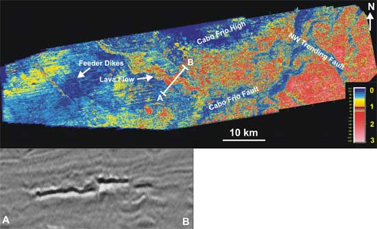
Figure 3: RMS amplitude
map extracted from a 3D seismic cube and encompassing
± 12 ms from the top of the Cretaceous (above),
showing the seismic signature of a channelized lava
flow (below). In the map, the hotter the colours, the
thicker the magmatic section.
To make visualization
of the subvertical dikes easier (Figure 4), because
they may be the most abundant in the areas where magmatic
manifestations occur, it is necessary to process the
seismic data with the use of special techniques. In
this work, the VA (Volume of Amplitudes) technique was
used. This method was developed by Bulhões
(1999) and improved by Bulhões & Amorim
(2005), and has improved visualization of volcanic systems,
as well as of sedimentary sequences, in general. The
technique comprises generating images that reinforce
structural and stratigraphic features contained in seismic
data, starting from any continuous surface of a three-dimensional
seismic volume, without the interference of a previous
interpretation (Bulhões, op. cit.).
An appropriate black and white color scale shows low
amplitudes as black zones. Continuous reflectors constitute
true timelines, because the VA technique enhances coherent
seismic attributes (continuous reflectors). Thus seismic
unconformities, faults, fractures and chaotic seismofacies
appear as dark colors. In the case of the present study,
subvertical volcanic dikes are interpreted as interruptions
in the continuity of the horizontal or relatively gently-dipping
reflectors.
It is interesting that
beneath each of the volcanic edifices, identified by
their conic form and chaotic internal seismofacies,
there is a group of continuous subvertical black features
that may represent fracture or fault zones, possibly
filled by magmatic rocks. These features in the sedimentary
section may represent the feeder dikes of the volcanic
and intrusive structures. The VA technique can also
be applied to 2D seismic sections and time slices, providing
a more accurate visualization of the dikes, lava flows,
sills and volcanic edifices.
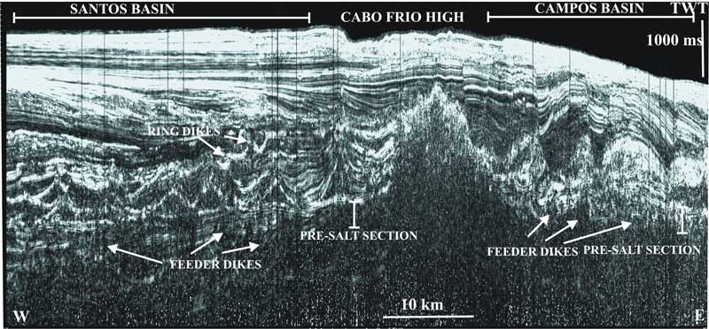
Figure 4: Along-strike
arbitrary seismic section in the study area, showing
the capacity of the VA technique to enhance dike swarms
and other near-vertical structures. Click here
or on figure for enlargement.
Finally, thicker magmatic
bodies can appear in seismic sections as packages with
well defined tops and poorly defined bases with low
seismic amplitudes in their inner part. In the well
shown in Figures 5 and 6, in its last 300 m, a homogeneous
body of holocrystalline dolerite was sampled (Souza
et al., 2001). This body may be either a shallow
intrusion, comprising the magmatic reservoir of the
volcano 2 km north of the well, or it may be a set of
submarine lava flows that occurred in a short time interval.
This may explain the absence of intercalated siliciclastic
sediments. Figures 5 and 6 show the position of the
volcano in relation to the well, poorly defined in Figure
5 but clearly visible in Figure 6 (processed with the
VA technique with a rotation phase of 90°). In Figure
6, there is a subvertical dike below the center of volcanic
edifice #2. This probably corresponds to the conduit
that transported the magma from its reservoir, at uncertain
depth, to the seafloor at the time of volcano formation.
In the normal seismic section shown in Figure 5, the
feeder dikes are mostly invisible. However, the top
and the base of the magmatic body are well marked by
strong positive reflectors, defining a relatively homogeneous,
low-amplitude zone.
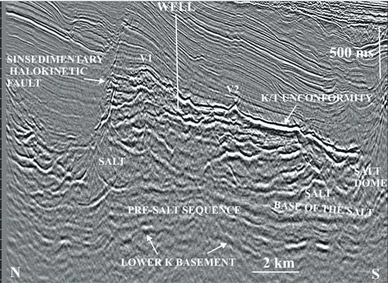
Figure 5: Section showing
the seismic signatures of magmatic features in the area.
Note that volcanic edifice #1 (V1) has a feeder dike
that appears like a rotated “Y”. The well
drilled, in its last 300 m, a section of compact dolerite.
The K/T unconformity, based on palaeontology, seems
to comprise older lava flows over which the volcanic
edifices were built.
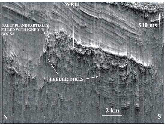
Figure 6: The same
section as the previous Figure, processed with the VA
technique (rotation phase of 90°) (Bulhões
& Amorim, 2005). This type of processing has the
advantage of making the seismic section similar to an
outcropping plane, enhancing the harder lithologies
(e.g, sandstones, volcanic rocks) relative to the softer
ones (e.g., shales). So, it can be seen that volcanic
edifice #2 (V2 on Figure 5) has a vertical feeder dike
which can be easily traced down to the lower limit of
resolution of the seismic section. Note that the halokinetic
fault plane in the upper right is partially filled with
magmatic rocks that are linked to volcanic edifice #1
(V1 on Figure 5).
3.
A genetic model for the post-Aptian magmatism
The detailed information provided by the three-dimensional
seismic survey between the Santos and Campos basins
revealed the presence of dikes, sills, lava flows and
volcanic edifices in several chronostratigraphic levels,
from the Albian to the Middle Eocene. Such features
are clearly aligned with SE-NW faults and fractures,
interpreted here as subvertical feeder dikes. Some of
the dikes observed in the Santonian and Campanian sections
have a “boomerang” form in seismic profiles.
These dikes are expressed by strong amplitude anomalies
in a window corresponding to the isochron of Campanian
RMS amplitude map (Figure 7).
Igneous activity is widespread
in the Upper Cretaceous and Eocene in the SW Campos
Basin, which is covered by a 3D seismic survey. This
can be deduced from the RMS amplitude maps extracted
from the seismic horizon windows corresponding to the
top of the Cretaceous and the Santonian. The main source
of the magmatism is not the Cabo Frio High in this area.
Practically all the volcanic edifices and intrusive
bodies have their own corresponding subvertical feeder
dikes, which are clearly visible in the seismic sections
processed with the VA technique. There is strong evidence,
based on seismic and well data, that the greatest thickness
of magmatic rocks coincides with intersections of NE
fault zones with NW ones. Besides, it is clear that
nearly all the volcanic edifices found in the SW portion
of the Campos Basin are aligned along both SW-NE and
SE-NW trends, parallel to the direction of the main
fault zones.
The SE-NW faults are interpreted
here as the main conduits of the post-Aptian magmatism.
Magmatic bodies of different ages are vertically superposed
in the area.
Based on the evidence presented above, it can be inferred
that the post-salt magmatism is more abundant where
pre-salt faults are more frequent. This statement is
also valid for the adjacent continental alkaline magmatism
represented by massive bodies generally placed at the
intersection of SE-NW and SW-NE fault zones (Figure
8). Therefore we suggest that the main magmatic control
in the marginal basins of SE Brazil and their adjacent
continental areas is reactivation of SE-NW deep transfer
fault zones and their intersections with SW-NE reactivated
normal fault zones. This information supports the interpretation
of Almeida (1991).
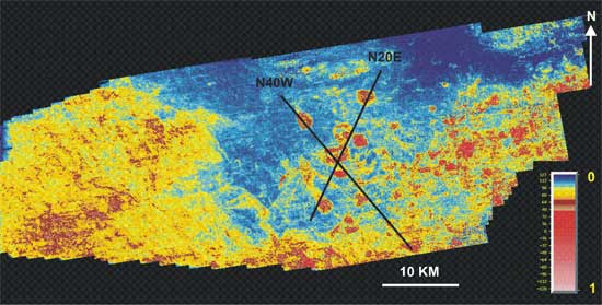
Figure 7: RMS amplitude
map of the Campanian isochron, showing images of ring
dikes (in red) located from the Santonian section up
to the K/T unconformity. The NE-aligned dikes are parallel
to the Cabo Frio Fault (Figure 3); the NW aligned dikes
are parallel to the faults and fractures that constitute
the feeder dikes for the post-Aptian magmatism.
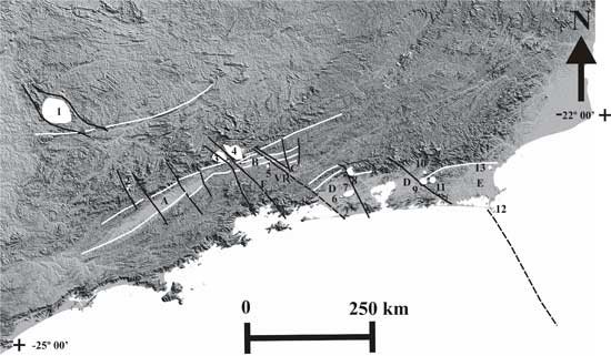
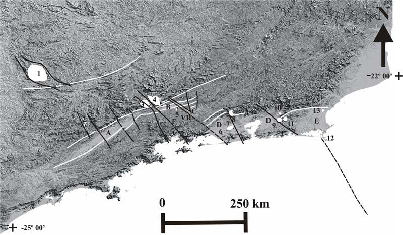
Figure 8: SRTM (Shuttle
Radar Topographic Mission) mosaic of a part of Southestern
Brazil, showing near-circular alkaline bodies (in white:
1, Poços de Caldas; 2, Ponte Nova; 3, Passa Quatro;
4, Itatiaia; 5, Morro Redondo; 6, Marapicu; 7, Mendanha;
8, Tinguá; 9, Soarinho; 10, Tanguá; 11,
Rio Bonito; 12, Ilha de Cabo Frio and 13, Morro de São
João). Also in white are linear old Precambrian
shear zones that were reactivated in the Cenozoic as
normal faults, forming the continental rift of southeastern
Brazil (Almeida, 1976; Riccomini, 1989; Riccomini et
al., 2004). Some of the structures that belong to the
rift are: A, Taubaté Basin; B, Resende Basin;
C, Volta Redonda Graben; D, Guanabara Graben and E,
Barra de São João Graben. The transfer
zones interpreted in the image by one of us (O.S.G.)
are shown as black alignments. F and VR are the Funil
(Almeida, 2001) and Volta Redonda Transfer Zones (Valeriano
& Heilbron, 1993), respectively. The data are from
NASA and were integrated and processed by the geologist
João Batista Françolin. Click here
or on figure for enlargement.
The petrographic characteristics
of the magmatism in the offshore areas close to the
Cabo Frio High (SW of Campos Basin and NE of Santos
Basin) and the data published in the literature up to
now show that this is basaltic magmatism. Most of the
well samples that were analyzed in the area indicate
that the Upper Cretaceous basaltic rocks are tholeitic.
This supports our inference that the transfer faults
that served as conduits for the magma reached the asthenosphere.
According to Anderson
(2000), the asthenosphere is chemically inhomogeneous
and its long wavelength temperature variations are ±
200°C. Such variations include the temperature excesses
that have been attributed to mantle plumes (Anderson,
2000). In addition, as a large portion of the upper
mantle is near its melting point, the criteria for dike
intrusion are:
- the minimum lithospheric compressional
stress is horizontal, and
- the buoyancy of the melted material
overcomes the active stress inside the plate.
Anderson
& Natland (2005) argue that the effects
of pressure on the properties of materials are not considered
in experiments and computational simulations of mantle
plumes. Their conclusion accords with our opinion that
magmatic events may occur without an associated mantle
plume.
The hypothesis of Almeida (1991) states that
a change in the pole of rotation of between South American
and African plates occurred from 80 My and was responsible
for deep faulting in the crust. These faults could have
reached the asthenospheric mantle and caused partial
melting by pressure release. Similar processes during
Santonian/Campanian and Paleocene/Eocene time could
explain the vertical overlap of igneous rocks in the
Cabo Frio area, in the same way as proposed in the general
model of Anderson
(2001).
Finally, Foulger
(2002) attributed the excessive magma production
in the Iceland Volcanic Province to high mantle fertility
associated with an older Caledonian subduction zone
that intercepts an active spreading center. In her opinion,
it is possible for magmatic events to occur without
high mantle temperatures in areas where there is subducted
oceanic crust. On a smaller scale, there are some similarities
between the situation in Iceland as seen by Foulger
(op. cit.) and that of the Cabo Frio area where,
in the last tectonic stage (520 – 490 Ma), the
Cabo Frio Domain overthrust the Oriental Terrane along
a SE dipping thrust fault (Schmitt et al.,
2004).
Such Early Paleozoic tectonism also created many zones
of weakness that were reactivated during Phanerozoic
tectonic episodes of intensification associated with
the Andean Orogeny. This may have been related to the
post-Aptian magmatic pulses described in the present
paper.
Finally, it should be
mentioned that Fairhead
& Wilson (2005) made a detailed study of
deformation processes in the South Atlantic Ocean, using
high-resolution satellite data (Ed: See also Sea-floor
spreading and deformation processes in the South Atlantic
Ocean: Are hot spots needed?). They suggested that
faults parallel to the motion of the South American
plate and orientated NW are most susceptible to reactivation,
at both the micro and macro scales. They also suggested
that the Rio Grande Rise probably suffered dextral shear
and extension (Figure 9). The feature they call the
Rio Grande Rise is the same as the Cruzeiro do Sul Deformation
Zone (CSDZ), first described by Souza (1991)
(Figure 9). In the present webpage, the Cabo Frio High
is interpreted as the landward continuation of the CSDZ.
Thus, the interpretation of Fairhead
& Wilson (2005) is in agreement with the
general conclusion presented here, that the intensification
of magmatic events on and around the Cabo Frio High
is caused by the reactivation of SE-NW transfer zones
that have been mapped in the 3D survey.
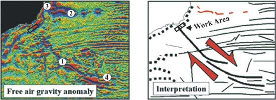
Figure 9: Image of
Free Air gravimetry (on the left) and the interpretation
of Fairhead
& Wilson (2005) (on the right). The notes added
by us are: (1) the Cruzeiro do Sul Deformation Zone
(Souza, 1991), (2) the Vitória-Trindade Fracture
Zone, (3) the Abrolhos Volcanic Complex and (4) the
Rio Grande Rise. The small rectangle is the work area
of the present paper.
4.
Conclusions
The post-salt magmatic events in the study area resulted
from the reactivation of deep fault zones, many of which
had been created by the breakup of the supercontinent
Gondwana. The accurate mapping of magmatic sections
in the area, using 3D conventional seismic data and
some of their attributes, such as the ones revealed
by the VA technique shows that the dikes and volcanic
edifices that were formed in Late Cretaceous and Early
Tertiary times frequently overlap vertically along SW-NE
and SE-NW fault and fracture zones formed by accommodation
to the movements of the South American plate. At the
intersections of these two fault systems, the magmatic
sections become wider and thicker, reaching thicknesses
of 500 m or more.
Reactivation of deep fault
zones seems to be the main cause of partial melting
of portions of the upper mantle by pressure release.
The magma generated by this process rises in subvertical
columns and sheets and reaches the surface forming volcanic
edifices, or it intrudes the sediments. This conclusion
strongly supports a non-plume origin for the magmatism
in the work area and its surroundings.
Acknowledgements
The authors wish to thank
Petrobras S. A. for permission to publish this paper.
References
- Almeida, F. F. M., 1991. O alinhamento
magmático de Cabo Frio. Atas do 2ş Simpósio
de Geologia do Sudeste, São Paulo, Brasil,
pp. 423-428.
- Almeida, F.F.M, 1979. The system of
continental rifts bordering the Santos Basin, Brazil.
An. Academ. Bras. de Ciências, 48
(supl.), 15-26.
- Almeida, S. H. S., 2001. Gravimetria
e tectônica do Cinturão Ribeira na região
limítrofe entre os estados de São Paulo
e Rio de Janeiro. UNESP, Tese de Doutoramento, 201
pp.
- Alves,
E. C., Maia, M. e Sichel, S. E., 2005. Zona de Fratura
de Vitória-trindade no Atlântico Sudeste
e suas implicações tectônicas
e magmáticas com a Borda Continental Sudeste. Anais
do III Simpósio de Vulcanismo e Ambientes
Associados. Cabo Frio, Rio de Janeiro, pp. 325-329.
- Anderson,
D. L., 2000. The thermal state of the upper mantle:
no roles for mantle plumes. Geophy. Res. Letters,
27, 3623-3626.
- Anderson,
D. L., 2001. Top-Down tectonics? Science,
93, 2016-2018.
- Anderson,
D. L., and J. H. Natland, 2005. A brief history of
the plume hypothesis and its competitors: Concept
and controversy, in Plates, Plumes, and Paradigms,
edited by G. R. Foulger, J.H. Natland, D.C. Presnall
and D.L. Anderson, Geological Society of America Special
paper 388, 119-145.
- Bulhões, E. M., 1999. Técnica
“VOLUME DE AMPLITUDES” para mapeamento
de feições estruturais. Anais do VI
Congresso Internacional da Sociedade Brasileira de
Geofísica, Salvador, Brasil.
- Bulhões, E. M., Amorim, W. N.,
2005. Princípio da sismocamada elementar e
sua aplicação à técnica
de volume de amplitudes (TecVa). Ninth International
Congress of the Brazilian Geophysical Society, Salvador,
Brasil.
- Fairhead,
M. J., and M. Wilson (2005), Plate tectonic processes
in the south Atlantic ocean: Do we need deep mantle
plumes? in Plates, Plumes, and Paradigms,
edited by G. R. Foulger, J.H. Natland, D.C. Presnall
and D.L. Anderson, pp. 537-554, Geological Society
of America.
- Foulger,
G. R., 2002. Plumes or plate tectonic processes?
Astronomy and Geophysics, 43,
6.19-6.23.
- Herz, N., 1977. Timing of spreading
in the South Atlantic: information from Brazilian
alcalik rocks. Geol. Soc. Am. Bull., 88,
101-112.
- Leslie, S. C., Moore, G. F., Morgan,
J. K., Hills, D. J., 2002. Seismic stratigraphy of
the Frontal Hawaiian Moat: implications for sedimentary
processes at the leading edge of an oceanic hotspot
trace. Marine Geology, 184,
143-162.
- Oreiro, S. G., 2002. Magmatismo e sedimentação
em uma área na plataforma continental de Cabo
Frio, Rio de Janeiro, Brasil, no intervalo Cretáceo
Superior – Terciário. Dissertação
de Mestrado, Universidade do Estado do Rio de Janeiro,
Brasil, 94 pp.
- Oreiro, S. G., Cupertino, J. A., Szatmari,
P., Thomaz Filho, A., 2005. Influence of pre-salt
alignments in the post-Aptian magmatism in the Cabo
Frio High and its surroundings, Santos and Campos
Basins, SE Brazil. Journal of South American Earth
Sciences, submitted.
- Ricominni, C., Sant’Anna, L.
G., Ferrari A. L., 2004. Evolução geológica
do rifte sontinental do Sudeste do Brasil. In Mantesso
Neto, V., Bartorelli, A., Carneiro, C. D. R, Brito
Neves, B. B. (eds), 2004. Geologia do Continente
Sul-Americano: evolução da obra de Fernando
Flávio Marques de Almeida. Ed. Beca, São
Paulo, Brasil, 647 pp.
- Sadowsky, G. R., Dias Neto, C. M.,
1981. O lineamento tectônico de Cabo Frio. Rev.
Bras. Geoc., 11, 209-212.
- Souza, R. S., Braga, O., Calazans,
M., Souza, M. K., 2001. Petrography of volcaniclastic
rocks of the Block BC-20, Campos Basin. Comunicação
Técnica TRO – 37/1. Petrobras –
Cenpes, internal technical report, 22 pp.
- Schmitt, R. S., Trouw, R. A. J., Pimentel,
M. M., 2004. Late amalgamation in the central part
of West Gondwana: new geochronolocical data and the
characterization of a Cambrian collisional orogeny
in the Ribeira Belt (SE Brazil). Precambrian Research,
133, 29-61.
- Szatmari, P., Conceição,
J. C. J., Destro, N., Eversen, N. M., York, D., Smith,
P. E., 2000. Tectonic and sedimentary effects of a
hotspot track of alkaline intrusions defined by Ar-Ar
dating in SE Brazil. International Geological Congress,
31, Rio de Janeiro, Brazil, abstracts, CD-ROM.
- Thomaz Filho, A., Cesero, P., Mizusaki,
A. M. P., Leão, J. G., 2005. Hotspot volcanic
tracks and their implications for South American Plate
motion, Campos Basin (Rio de Janeiro State), Brazil.
Journal of South America Earth Science, 18,
383-389.
- Thompson, R. N., Gibson, S. A., Mitchell,
J. G., Dickin, A. P., Leonardos, O. H., Brod, J. A.,
Greenwood, J. C., 1998. Migrating Cretaceous –
Eocene magmatismo in the Serra do Mar Alkaline Province,
SE Brazil: melts from the deflected Trindade Mantle
Plume? J. Petrology, 39,
1493-1526.
- Valeriano, C. M., Heilbron, M., 1993.
A Zona de Transtensão de Volta Redonda e sua
importância na junção entre os
riftes do Vale do Paraíba e o da Guanabara.
Atas do III Simpósio de Geologia do Sudeste,
Rio de Janeiro, Brasil, 9-15.
- Zalán, P. V., Oliveira, J. A.
B., 2005. Origem e evolução estrutural
do Sistema de Riftes Cenozóicos do Sudeste
do Brasil. Boletim de Geociências da Petrobras,
13, no. 2.
last updated 27th
April, 2006 |