 |
Great
elliptical basin, western United States: Evidence
for top-down control of the Yellowstone hot spot and
Columbia River Basalt Group |
James W. Sears
University of
Montana, Missoula MT 59812
james.sears@umontana.edu
Abstract
The Middle Miocene outbreak point
of the Yellowstone hot spot (YHS) and Columbia River
Basalt Group (CRBG) occupies the exact center of a
surprisingly symmetrical, ~900,000 km2 elliptical
basin, where the western United States lithosphere
is attenuated. The ellipse includes the Great Basin
and adjacent parts of the Columbia and Missouri River
basins and encloses concentric rings of grabens and
horsts. Middle Miocene grabens and dikes radiate outward
for hundreds of kilometers from the center of the ellipse.
The grabens filled with Middle Miocene and younger
lake beds, river sediments, and volcanics above angular
unconformities that were eroded on volcanic and sedimentary
rocks as young as late Lower Miocene.
The ellipse evidently formed in response to dextral
torsion between the North American and Pacific plates,
between the Walker Lane of Nevada and the Lewis and
Clark line of Montana and Idaho. Attenuation within
this elliptical region may have driven decompression
melting in the Paleogene arc region of the Cordillera.
Magma then migrated toward the center of the ellipse
and erupted as the Columbia River Basalt Group (CRBG).
Depletion of the magma from the margins of the ellipse
collapsed the ring-grabens, rather like a mega-caldera.
The ellipse continues to extend. Its widening minor
axis parallels North American plate motion.
The geometric and temporal linkage of the elliptical
basin to plate boundaries, shear zones, and tectonic
domains supports top-down, lithospheric control for
the CRBG and YHS, rather than the eruption of a randomly
arisen deep-mantle plume.
Introduction
Geologists debate the origins of hot spots and associated
large igneous provinces. Morgan (1972), Richards
et al. (1989), and Ernst & Buchan (2001)
think that hot spots and large igneous provinces represent
outbreaks of deep mantle plumes. In contrast, Anderson (1994)
and authors in Foulger et al. (2005) and Foulger & Jurdy (2007)
propose that these features may form where lithospheric
attenuation triggers decompression melting.
Pierce & Morgan (1992) and Hooper
et al. (2007) interpret the Yellowstone hot
spot (YHS) and its companion, the Columbia River
Basalt Group (CRBG) of the western United States
as having erupted from a Middle Miocene mantle plume.
Conversely, Eaton (1984), Hart & Carlson (1987), Smith (1992), Christiansen
et al. (2002), Hales et al. (2005),
and Hamilton (2007) propose an upper mantle
origin. Humphreys et al. (2000) and Yuan & Dueker (2005)
show that the tomographic anomaly that may represent
the feeder channel for the active YHS volcano does
not extend below the upper mantle.
Pierce & Morgan (1992) and Hooper
et al. (2007) locate the outbreak region of
the YHS/CRBG at the common borders of Idaho, Oregon,
and Nevada, the sites of the oldest CRBG flows and
the oldest and hottest silicic volcanic fields of
the YHS track.
Here I show that the outbreak region occupies the
exact center of a surprisingly elliptical structural
basin that embraces much of the Great Basin, Columbia
River Basin, and upper Missouri River Basin (Figure
1). The track of the YHS curves from the center of
the ellipse to its NE side. The elliptical basin is
a first-order tectonic element of the Cordilleran lithosphere
that began to form during leadup to the outbreak of
the YHS/CRBG, and continues to widen today.
Figure 1: Great elliptical structure
of the western United States (yellow dashed ellipse).
Black lines–edge and internal divisions of elliptical
structure shown in Figures 2 and 3. Blue lines–major
rivers of the western United States influenced by the
elliptical structure. Red arrow–path of the Yellowstone
hot spot. Red (+)–geometric center of the ellipse
and outbreak point of the Yellowstone hot spot and
Columbia River Basalt Group.
The bulk of the CRBG erupted between 17.5 and 15.5
Ma (Tolan et al., 1989). Figure 2 shows dike
swarms and fractures that radiated from the outbreak
point during this time span. These include the Monument,
Joseph, and Cornucopia dike swarms, northern Nevada
rift, grabens in Idaho, Montana, Wyoming, Utah, Colorado,
Arizona, Nevada, and Oregon, and the Olympic-Wallowa
lineament (Sears, 1995; Sears & Thomas,
2007; Hooper et al., 2007; Sears et al.,
2009).
Figure 2: Middle and Late Miocene
structural features of the western USA that define
the great elliptical structure (red dashed line)
centered on the outbreak area of the CRBG/YHS (central
area). Green–uplifted
rim. Heavy red lines–mafic dike swarms. Medium
red lines–radial faults. Heavy arrows–dextral
shear couple between Lewis and Clark line and Walker
lane. Red ellipses–YHS silicic volcanic centers
of the eastern Snake River Plain, after Pierce & Morgan
(1972). Abbreviations, clockwise from north: JDS-Joseph
dike swarm; YHS Yellowstone hot spot; SGG–Sweetwater-Granite
graben; BPG–Browns Park graben; GDS–Gibsonite
dikes; PG–Paradox grabens; CRC–Colorado
River corridor; NNR–Northern Nevada rift; WHG–West
Humbolt graben; HLP–High Lava Plains; BFZ–Brothers
fault zone; PCG–Portland Hills-Clackamas graben;
MDS–Monument dike swarm; PB–Pasco basin;
OWL–Olympic-Wallowa lineament; CDS–Cornucopia
dike swarm. Base map from Reed et al. (2004). Inset:
simplified map showing how the major axis of the ellipse
links into the tips of the Lewis and Clark line (LCL)
and the Walker lane (WL). Shear couple widens the ellipse.
The disturbance coincided with an unusually wet climatic
period in the region (Thompson et al., 1982)
and the elliptical basin and associated radial fractures
captured deep lakes and channeled the Missouri and
Columbia rivers.
The great elliptical basin
The elliptical basin is elongate to the NNW and encloses
an area of ~900,000 km2. Its major and minor axes measure
~1200 km and ~900 km. The ellipse overlies a tectonically
complex region that includes parts of the ancient North
American craton, Cordilleran fold and thrust belt,
accreted oceanic terranes, and magmatic arcs (e.g.,
Burchfiel et al., 1992). It mostly occupies the
region of the Paleogene Cordilleran magmatic arc, characterized
by relatively thin, hot, volatile-rich, weak
crust and lithosphere (Dickenson, 1998; Hyndman
et al., 2005; Marone & Romanowicz,
2007; Thatcher & Pollitz, 2008; Sine
et al., 2008). The crust thins from 40-50 km under
parts of the rim to 20-30 km under parts of the interior.
Some of the highest mountains in the
western USA lie on the elliptical rim. These include
the Wasatch Range, Sierra Nevada, and Northern Cascades.
Normal fault scarps that had Middle Miocene activity
outline most of the rim of the ellipse. Many of these
activated older structures that had appropriate orientations
to accommodate the disturbance–individual fault
zones tend to have complex histories but experienced
a Middle Miocene crescendo. The rim faults exhibit
3-5 km of throw and Middle Miocene sediments or volcanics
onlapped rim faults that displaced rocks as young as
Oligocene and Early Miocene. (Christiansen & McKee,
1978). An early Paleogene erosional surface descends
outward from the ellipse rim across broad, gently-sloping
mountain blocks. Major rivers flow in concentric troughs
along the lower edges of these tilted blocks. NW-trending,
dextral-extensional fault zones bound the ellipse on
the NE (the Lewis and Clark line), and on the SW (the
Walker lane). Several NW-trending shear zones segment
the interior of the ellipse (Stewart,
1998).
The distributions of Middle and Upper Miocene grabens,
lake beds, and volcanics within the ellipse define
a succession of nested elliptical rings, including
a marginal ring-graben complex, a peak-ring, and an
inner ring-graben (Figure 3). The ellipse-bounding
faults remain active. Figure 4 maps seismic risk along
the east and west rims of the ellipse (Smith & Arabasz,
1991; USGS, 2008).
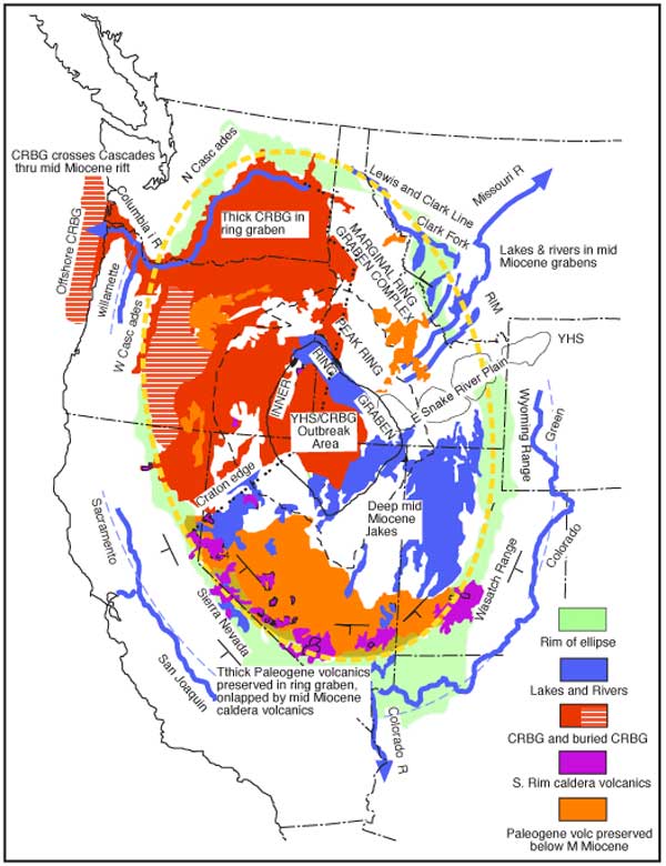
Figure 3: Geologic units that
define Middle Miocene nested elliptical rings centered
on the outbreak area of the CRBG/YHS. Yellow dashed
line–best
fit ellipse centered on the CRBG/YHS outbreak area.
Dotted line–western edge of the Precambrian basement
of North America. Most of the CRBG lies west of this
edge. Blue–Middle Miocene lakes and rivers; orange–CRBG;
orange hatchured–CRBG covered by Pleistocene
Cascade volcanics and offshore; brown–Paleogene
and Early Miocene volcanics preserved below the Middle
Miocene unconformity; purple–Middle Miocene caldera
volcanics; green–elliptical rim. Dashed black
line–inner edge of Paleogene rocks below the
Middle Miocene unconformity. Dashed light blue curves–structural
troughs at edges of rim with major rivers. Lakes and
flood basalts are ponded in ring grabens. Missouri
and Columbia Rivers flow out of the ellipse via radial
fractures. Green, middle Colorado, San Joaquin, Sacramento,
and Willamette Rivers follow structural troughs along
outer edges of the elliptical rim. The lower Colorado
River follows the radial Colorado River extensional
corridor. The Columbia River shifted its course eastward
upon uplift of the Yakima fold belt (not shown).
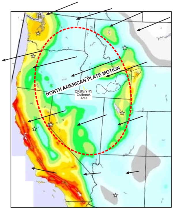
Figure 4: The short axis of the
great ellipse parallels North American plate motion
(arrows), as shown by olivine anisotropy in sublithospheric
mantle (Marone & Romanowicz, 2007). The ellipse
widens in this direction, suggesting tensional pull
of North American plate, as advocated by Hamilton
(2007). Color patterns show seismic risk, from USGS
National Seismic Hazard Maps. Warm colors indicate
higher seismic risk.
The following sections highlight specific geological
observations that correlate initiation of the elliptical
structure with the main phases of YHS and CRBG eruption.
NE sector
The Lewis and Clark line (LCL) bounds the ellipse
in northern Idaho and western Montana (Figure 2). This
structure originated as a Mesoproterozoic rift zone
(Sears, 2007a). It experienced dextral extension
during the Middle Miocene disturbance that initiated
the ellipse (Sears & Hendrix, 2004; Wallace
et al., 1990), accumulating 26 km of dextral slip
in northern Idaho (Harrison et al., 1974).
Commonly, as much as 5 km of vertical throw, SW-side
down, occurs between uplifted rim segments and adjacent
grabens. Middle Miocene fluvial and alluvial sediments
and CRBG basalts fill canyons along the LCL and unconformably
overlie tilted strata as young as late Lower Miocene,
bracketing the disturbance to 20-17 Ma (Fields
et al., 1985; Smiley, 1989). Massive
debris flows descended inward from the rim and aggraded
alluvial fans in the grabens (Sears, 2007b).
NE-trending grabens radiated from the YHS/CRBG outbreak
region and intersected NW-trending ring-grabens to
form a complex interference pattern near the rim of
the ellipse (Pardee, 1950). Deep rift lakes
were ponded at the intersections (McLeod,
1987; Sears & Ryan, 2003; Smith et
al., 1989). Provenance of some Middle and Upper
Miocene river cobbles indicate that rivers flowed NE
from the uplifted peak-ring region (Sears & Ryan,
2003; Sears et al., 2009). The Miocene Clark
Fork River was diverted into the ring-grabens across
NW Montana (Figure 3). The Miocene Missouri River exited
the ellipse to the NE via radial fractures that broke
across the Lewis and Clark line.
The eastern Snake River Plain separates the NE and
SE sectors of the elliptical basin. Armstrong et
al. (1975), Pierce & Morgan (1992), Smith & Braille (1993), Perkins & Nash (2002),
and others show that the ages of silicic volcanic fields
young systematically toward the NE along the eastern
Snake River Plain, from 16.5 Ma in the SW to the active
Yellowstone volcano in the NE. The age progression
approximates the direction of movement of the North
American plate over a fixed mantle reference, and the
plain is usually interpreted as the track of the Yellowstone
hot spot (Anders et al., 1989; Beranek
et al., 2006; Hackett & Morgan, 1988).
Hamilton (2007) and others, however, interpret
the plain as a propagating fracture with Yellowstone
at its tip. The older parts of the track were extended
with the Basin and Range province. Therefore, the length
of the eastern Snake River Plain, restored for extension,
may be significantly shorter than the correlative displacement
of North American plate. If so, the YHS would
not be fixed in the mantle reference frame.
SE sector
The Wasatch and Wyoming Ranges, on the eastern edge
of the Great Basin, define the rim of the ellipse in
eastern Utah, SE Idaho, and SW Wyoming. Much of the
edge in this sector follows the Wasatch line, a Neoproterozoic
rift (Link, 1993). Zoback (1983)
summarizes the structure of this region of the Great
Basin. An exhumed Paleogene erosional surface was faulted
down into a dozen north-trending, east-tilted blocks
in the ring graben. The faults have 3-5 km of throw
and were active during deposition of the Middle and
Late Miocene Salt Lake Formation, a thick lacustrine
deposit (Piety et al., 1992). Four kilometers
of late Cenozoic sediments accumulated in the ring-graben
zone (Zoback, 1983).
Radial features include the Sweetwater Pass-Granite
Mountains grabens of central Wyoming (Love,
1970), Browns Park graben of western Colorado and NE
Utah (Hansen, 1965), a gibsonite dike swarm
(Verbeek & Grout, 1993), and the Paradox
and other grabens.
The Wasatch rim slopes gently eastward to the Green
River and middle course of the Colorado River. These
rivers flow in an arc that is concentric to the ellipse
rim. Uplift of the elliptical rim may have reversed
the regional westward slope off the Continental Divide
and diverted runoff from the Colorado Plateau and western
Wyoming into the resulting structural trough. Middle
and Late Miocene faulting along the ellipse rim and
Colorado River extensional corridor may have instigated
headward erosion into the western Colorado Plateau
to trigger incision of the Grand Canyon (Longwell,
1960; Fedo & Miller, 1992; Young, 2008; Karlstrom
et al., 2008).
SW sector
Oligocene and Lower Miocene volcanics as thick as
6 km (Stuckless & O’Leary, 2007)
dip gently south in the ring-graben zone and abut fault
zones that define the ellipse rim (Ekron et al.,
1968). Middle Miocene volcanics overlie these thick
volcanics within the ellipse, but lap on to pre-Cenozoic
bedrock to the SW, showing that the ring-graben faults
were active in early Middle Miocene. A 500-km arc of
Middle Miocene calderas closely follows the southern
boundary of the ellipse, from SW Utah to western Nevada.
Middle Miocene lake and river beds onlapped the caldera
volcanics (Bonham & Garside, 1979). The
17 Ma northern Nevada rift (Zoback et al.,
1994) forms a major radial basaltic trend across this
sector. The Middle Miocene rocks are broken by numerous
younger Neogene extensional faults that widened the
ellipse.
In eastern California, the Sierra Nevada elevates
segments of the ellipse rim (Wernicke & Snow,
1998). Easterly-sourced Miocene volcanics bracket initiation
of uplift of the northern Sierra Nevada to 20-17 Ma.
The Miocene volcanics abruptly thin from 4 km within
the ring-graben zone of the ellipse, near Reno, Nevada,
to less than 400 m in the northern Sierra Nevada, indicating
~ 4 km of Middle Miocene structural relief (Slemmons,
1966; Bonham, 1969). The rim of the ellipse
slopes gently down the SW flank of the Sierra Nevada
on an exhumed Paleogene erosional surface – the
mirror image of the Wasatch Range. The Sacramento and
San Juaquin rivers follow the base of this slope, mimicking
the Colorado and Green rivers. Unruh (1991)
showed that much of the tilting occurred in the late
Neogene. Phillips (2008) summarized the extensional
history as beginning at ca. 16 Ma and migrating westward.
The tectonically active Walker lane along the NE side
of the Sierra Nevada has dextral slip (Billingsley & Locke,
1939; Wernicke, 1992; Henry et al., 2007)
and lies on the opposite boundary of the ellipse from
the LCL of Montana. Together they comprise a simple
shear couple that widens the ellipse (Figure 2, inset).
NW sector
The High Cascade volcanic chain follows the rim of
the ellipse from northern California to southern Washington.
Greenschist-facies volcanic and plutonic rocks of the
Oligocene-Early Miocene western Cascades magmatic arc
form the uplifted rim of the ellipse (Evarts & Swanson,
1994). At 17 Ma, the magmatic arc abruptly extinguished
and the arc rocks were faulted up by 3 km. Meanwhile,
the CRBG flowed across the subsiding Columbia Plateau
and onlapped the rim (Evarts & Swanson,
1994). The Columbia River hugged the NW edge of the
elliptical depression during the 16.5-15.6 Ma Grande
Ronde eruption, so that river gravels with sources
in quartzite terranes of the eastern Cordillera were
interlayered with basalts (Smith, 1988). The
Pasco basin, a structure radial to the outbreak point
of the YHS/CRBG, sank during eruption and filled with
some 5 km of CRBG (Hooper et al., 2007).
The Columbia River Gorge crosses the Cascades along
a rift (Beeson et al., 1989) that is radial
to the CRBG outbreak point. The rift cross-cut the
Paleogene rocks of the Cascades, and was flooded by
Middle Miocene CRBG that flowed through the gorge to
the Pacific Ocean.
CRBG occurs along a ~200 km length of the Oregon-Washington
coast. Seismic reflection profiles across the Oregon
shelf reveal CRBG reflectors dipping seaward for at
least 15 km offshore (McNeill et al., 2000).
An unknown volume of CRBG flowed onto the Juan de Fuca
plate only to be subducted or accreted into the Cascadia
trench wall. The oldest remaining sea floor on the
plate is 10 Ma, whereas the bulk of the CRB erupted
from 17-15 Ma (Tolan et al., 1989).
The peak-ring
An irregular peak-ring rises inward from the marginal
ring-graben zone. Middle Miocene volcanics and lake
beds lap downward from Paleogene volcanics to pre-Eocene
bedrock on the peak-ring. A rough elliptical line marks
the truncated inner edge of Paleogene volcanics beneath
the middle Miocene unconformity (Figure 3). The peak-ring
includes some of the higher topography of the interior
of the elliptical depression, including numerous 3-km
peaks. The peak-ring faces into the inner ring-graben
and central volcanic region.
The inner ring-graben and central volcanic
region
The inner ring-graben defines an ellipse with rectilinear
margins (Figure 3). It encloses the central volcanic
region (YHS/CRBG outbreak area). The segments of the
inner ring-graben are about 50 km wide. Some collected
as much as 3 km of Middle and Upper Miocene lake beds
(Swirydczuk et al., 1982). The NW side faulted
16.6 Ma flows of the CRBG and filled with sediments
and volcanics beginning at 15.5 Ma (Cummings et
al., 1994). The 12 Ma Bruneau-Jarbridge volcanic
center of the YHS track cross-cuts the ring-graben.
The inner ring-graben thus formed after 16.6 Ma and
before 12 Ma. It may represent a mega-caldera for the
16.5 Ma Idavada felsic volcanic field.
The central volcanic region marks the outbreak site
of the YHS/CRBG. Honjo et al. (1992) document
the enormous and vigorous nature of high temperature
silicic eruptions from the central volcanic region
during birth of the YHS.
Discussion
Several authors, beginning with Billingsley & Locke (1939)
and Locke et al. (1940), propose that dextral
torsion between the Walker lane and Lewis and Clark
line extended the Great Basin. Atwater (1970)
shows from plate tectonic circuits that impingement
of the Pacific plate against the North American plate
initiated dextral torsion at about 20 Ma. Dickenson (1997)
proposes that torsion thinned the lithosphere in the
region, and triggered CRBG eruption by destabilizing
the sublithospheric mantle, which had been charged
with melt-enhancing volatiles during its long history
above the Pacific rim subduction zone. Hyndman
et al. (2005) propose that thin, hot, wet lithosphere
in this region is extremely weak and susceptible to
variations in tectonic stresses, and that high elevations
are supported by small convection cells in volatile-rich
asthenosphere. Recent work by Sine et al. (2008)
confirms small-scale convection along the SE edge of
the ellipse.
I suggest that the ellipse specifically defines a
lithospheric domain that stretched in the soft plate
boundary zone between the Walker lane and Lewis and
Clark line, beginning at 20 - 17 Ma, and continuing
today. The major axis of the ellipse links the NW tip
of the Lewis and Clark line with the SE tip of the
Walker lane (Figure 1, inset). The ellipse may have
initiated somewhat like a tension gash between the
dextral faults. It then broadened and thinned as the
margins collapsed on inward-dipping listric normal
faults.
Absolute motion of the North American plate determined
by olivine anisotropy in the sublithospheric mantle
(Marone & Romanowicz, 2007) parallels
the widening minor axis of the ellipse (Figure 4).
The margins of the ellipse remain seismically active
(Figure 4).
Interpretation & summary
I suggest the following interrelated events and features:
- Upon impingement of the Pacific and North American
plates, dextral torsion between the LCL and Walker
lane attenuated the Cordilleran lithosphere in the
region of the ellipse beginning at 20 Ma.
- As the lithosphere thinned, decompression of underlying
hot, volatile-rich asthenosphere generated basaltic
magma within the elliptical region.
- The basaltic magma expanded the asthenosphere,
forming a broad elliptical dome in overlying, thinning
lithosphere.
- Radial grabens plunged down the lithospheric dome
and captured runoff from the center of the ellipse
during the 20-17 Ma erosional episode. Rainbird & Ernst (2001)
document similar radial erosion patterns for other
hot spot-large igneous province outbreaks. Runoff
escaped via ring-grabens where radial fractures cut
across the rim. Two main escape points channeled
the Missouri and Columbia rivers.
- Once sufficient basalt had melted to achieve melt
phase connectivity, it migrated upward toward the
center of the elliptical dome.
- Migration of magma toward the center of the dome
further uplifted the peak-ring, while sapping of
magma from the marginal ring-grabens produced a pattern
resembling a mega-caldera.
- As it accumulated in the center of the ellipse,
CRBG magma melted the overlying crust, leading to
voluminous, superheated silicic eruptions that heralded
the birth of the YHS.
- The CRBG erupted from radial fissures and filled
the especially low NW quartile of the elliptical
basin, west of the old craton edge (dotted line in
Figure 3). Eruption of CRBG magma caused the inner
ring-graben to collapse as the center of the ellipse
drained.
- The CRBG onlapped the rim of the ellipse, showing
that the ellipse had gained its essential form before
CRBG eruption. The Columbia Plateau has a smoother
physiography than Great Basin, perhaps because the
CRBG buried earlier structures associated with initial
extension of the ellipse.
- An unknown volume of basalt escaped the ellipse
through the radial graben along the Columbia River
Gorge and flowed onto the Juan de Fuca plate. It
was later subducted or accreted into the subduction
wedge. Previous volume estimates of the CRBG are
therefore minimums.
- Eruptions coincided with an unusually wet climatic
period in the region, and immense, deep lakes and
large rivers established new drainage patterns across
the tectonically disturbed land.
- Ongoing extension broadens the ellipse in the direction
of North American plate drift and Late Cenozoic faults
break the volcanic and sedimentary rocks that record
initiation of the YHS/CRBG.
- The YHS hot spot track may follow an older radial
fracture of the ellipse that parallels North American
plate motion, exploited by lingering ascent of magma
from the asthenospheric site of the original outbreak
(e.g., Christiansen et al., 2002).
The geometric and temporal linkages between the YHS/CRBG
outbreak and the inception of the great elliptical
basin imply that, rather than impingement of a random
deep-mantle plume, lithospheric thinning induced by
dextral torsion between the Pacific and North American
plates triggered the outbreak of YHS/CRBG volcanism.
Acknowledgements
I thank students and colleagues at
the University of Montana and in the Tobacco Root Geologic
Society for discussions, seminars, and field trips
that helped clarify some of the arguments presented
in this paper. I especially thank Don Winston, Marc
Hendrix, Rob Thomas, Bill Fritz, and Julie Baldwin.
Aaron Deskins helped with Figure 1. I thank Ray Price
for reviewing an earlier version of the manuscript
and making valuable suggestions. Many thanks to Gillian
Foulger for her careful editing and insightful criticism
of an earlier version of the manuscript.
References
-
Anders, M. H., Geissman, J. Wm., Piety, L. A., and
Sullivan, J. T., 1989, Parabolic distribution of circum-eastern
Snake River Plain seismicity and latest Quaternary
faulting: migratory pattern and association with the
Yellowstone hot spot, J. Geophys. Res., 94,
1589-1621.
-
Armstrong, R.L., Leeman, W., and Malde, H.E., 1975,
K-Ar dating, Quaternary and Neogene volcanic rocks
of the Snake River Plain, Idaho, Am. J. Sci., 275,
225-251.
-
Anderson, D.L., 1994, The sublithospheric mantle
as the source of continental flood basalts; the case
against the continental lithosphere and plume head
reservoirs, Earth
Planet. Sci. Lett., 123,
269-280.
-
Atwater, T., 1970, Implications of plate tectonics
for the Cenozoic tectonic evolution of western North
America, Geol. Soc. Am. Bull., 81,
3513-3563.
-
Beeson, M.H., Tolan, T.L., and Anderson, J.L.,
1989, The Columbia River Basalt Group in western
Oregon; geologic structures and other factors that
controlled flow emplacement patterns, in Reidel,
S., and Hooper, R., eds., Volcanism and tectonism in the Columbia
River Flood-Basalt Province, Geol. Soc. Am.
Spec. Pap., 239, 233-246.
-
Beranek, L. C. Link, K. and Fanning, C. M., 2006,
Miocene to Holocene landscape evolution of the western
Snake River Plain region, Idaho: Using the SHRIMP
detrital zircon provenance record to track eastward
migration of the Yellowstone hot spot, Geol. Soc. Am. Bull., 118,
1027-1050, DOI: 10.1130/B25896.1
-
Billingsley, and Locke, A., 1939, Structure of
ore districts in the continental framework, Am. Inst.
Min. Met. Eng., New York, 51 pp.
-
Bohannon, R.G., 1983, Mesozoic and Cenozoic tectonic
development of the Muddy, North Muddy, and northern
Black Mountains, Clark County Nevada, in Miller,
D.M., and Howard, K.A., eds., Tectonic and stratigraphic
studies in the eastern Great Basin, Geol.
Soc. Am. Mem., 157, 125-148.
-
Bonham, H.F., 1969, Geology and mineral deposits
of Washoe and Storey Counties, Nevada, Nevada Bureau
of Mines, Bull., 70, 140
pp.
-
Bonham, H.F., and Garside, L.J., 1979, Geology
of the Tonopah, Lone Mountain, Klondike, and Northern
Mud Lake Quadrangles, Nevada, Nevada Bureau of
Mines, Bull., 92, 142 pp.
-
Burchfiel, B.C., Cowan, D.S, and Davis, G.A., 1992,
Tectonic overview of the Cordilleran orogen in the
western United States, in Burchfiel, B.C., Lipman,
W., and Zoback, M.L., eds., The Cordilleran Orogen:
Conterminous US: Boulder, Colorado, Geol.
Soc. Am., G-3, 407-478.
-
Christiansen, R.L., Foulger, G.R., and Evans, J.R.,
2002, Upper mantle origin of the Yellowstone hot
spot, Geol.
Soc. Am. Bull., 114, 1245-1256.
-
Christiansen, R. L., and McKee, E. H., 1978, Late
Cenozoic volcanic and tectonic evolution of the Great
Basin and Columbia intermontane regions, Geol.
Soc. Am. Mem. 152, 388 pp.
-
Cummings, M.L., Evans, J.G., and Ferns, M.L., 1994,
Stratigraphic and structural evolution of the Middle
Miocene Oregon-Idaaho graben, Malheyr County, Oregon,
in Swanson, D.A., and Haugerud, R.S., eds., Geologic
field trips in the Pacific Northwest, 1, Dept
Geological Sciences, University of Washington, Seattle,
Washington., 1G 1-20.
-
Dickenson, W.R., 1997, Tectonic implications of
Cenozoic volcanism in coastal California, GA Bull., 109,
936-954.
-
Eaton, G., 1984, The Miocene Great Basin of western
North America as an extended back-arc region, Tectonophysics, 1102,
275-295.
-
Ekren, E.B., Rogers, C.L., Anderson, R.E., and
Orkild, 1968, Age of Basin and Range normal faults
in Nevada Test Site and Nellis Air Force range, Nevada, in Ekren,
E.B., ed., Nevada Test Site, Geol. Soc. Am. Mem., 110,
247-262.
-
Ernst, R.E., and Buchan, K.L., 2001, Large mafic
magmatic events through time and links to mantle
plume-heads, in Ernst,
R.E.. and. Buchan, K.L., eds., Mantle Plumes: Their
identification through time, Geol. Soc. Am.
Spec. Pap., 352, 483-575.
-
Evarts, R.C., and Swanson, D.A., 1994, Geologic
transect across the Tertiary Cascade Range, southern
Washington, in Swanson, D.A., and Haugerud, R.S.,
eds., Geologic
field trips in the Pacific Northwest, 2, Dept
Geological Sciences, University of Washington, Seattle,
Washington, 2H1-31.
-
Fedo, C.M, and Miller, J.M.G., 1992, Evolution
of a Miocene half-graben basin, Colorado River extensional
corridor, southeastern California, Geol. Soc. Am.
Bull., 104, 481-493.
-
Fields, R. W., Rasmussen, D. L., Nichols, R., and
Tabrum, A. R., 1985, Cenozoic rocks of the intermontane
basins of western Montana and eastern Idaho, in,
Flores, R. M. and Kaplan, S. S., eds., Cenozoic paleogeography
of the west-central United States, Rocky Mountain
Section of the Society of Economic Paleontologists
and Mineralogists, 9-36.
-
Foulger, G.R., and Jurdy, eds., 2007. Plates,
plumes, and planetary processes, Geol. Soc.
Am. Spec. Pap., 430, 997
pp.
-
Foulger, G.R., J.H. Natland, D.C. Presnall and
D.L. Anderson, Eds., 2005, Plates, Plumes, and Paradigms, Geol.
Soc. Am. Spec. Pap., 388,
881 pp.
-
Friedmann, S.J., Davis, G.A., and Fowler, T.K.,
1996, Geometry, paleodrainage, and geologic rates
from the Miocene Shadow Valley supradetachment basin,
eastern Mojave Desert, California. In: Beratan, K.
K, ed., Reconstructing
the History of Basin and Range Extension Using Sedimentology
and Stratigraphy, Geol. Soc. Am. Spec. Pap., 303,
85-106.
-
Hackett, W. R., and Morgan, L. A., 1988, Explosive
basaltic and rhyolitic volcanism of the eastern Snake
River Plain, Idaho, in, Link, K., and Hackett, W.
R., eds., Guidebook to the geology of central Idaho,
Idaho Geol. Surv. Bull., 27, 283-301.
-
Hales, T.C., Abt, D.L., Humphreys, E.D., and Roering,
J.J., 2005, Delamination origin for the Columbia
River flood basalts and Wallowa uplift in NE Oregon,
USA, Nature, 110,
1038.
-
Hamilton, W.B., 2007, Driving mechanism and 3-D
circulation of plate tectonics, in Sears,
J.W., Harms. T.A., and Evenchick, C.A., eds., Whence the Mountains?
Inquiries into the Evolution of Orogenic Systems: A
Volume in Honor of Raymond A. Price, Geol.
Soc. Am. Spec. Pap., 433,
1-26.
-
Hansen, W.R., 1965, Geology of the Flaming Gorge
area, Utah-Colorado-Wyoming, U.S. Geol.
Surv. Prof. Pap. 490, 196
pp.
-
Harrison, J.E., Griggs, A.B., and Wells, J.D.,
1974, Tectonic
features of the Precambrian Belt basin and their
influence on post-Belt structures, U.S.
Geol. Surv. Prof. Pap. 866,
15 pp.
-
Hart, W.K., and Carlson, R.W., 1987, Tectonic controls
on magma genesis and evolution in the northwestern
United States, J. Volc. Geotherm. Res., 32,
119-135.
-
Henry, C.D., Faulds, J.E., and dePolo, C.M., 2007,
Geometry and timing of strike-slip and normal faults
in the northern Walker lane, northwestern Nevada
and northeastern California: Strain partitioning
or sequential extension and strike-slip deformation?
in Till, A.B., Roeske, S.M., Sample, J.C., and Foster,
D.A., eds., Exhumation associated with continental
strike-slip systems: Geol. Soc. Am. Spec. Pap., 434,
59-79.
-
Honjo, N., Bonnichsen, B., Leeman, W., and Stormer,
J.C., Jr., 1992, Mineralogy and geothermometry of
high-temperature rhyolites from the central and western
Snake River Plain, Bull. Volc., 54,
220-237.
-
Hooper, R., Camp, V.E., Reidel, S., and Ross, M.E.,
2007, The origin of the Columbia River flood basalt
province: Plume versus nonplume models, in Foulger,
G.R., and Jurdy, D.M., eds., Plates, Plumes, and
Planetary Processes, Geol. Soc. Am. Spec.
Pap., 430, 997 pp.
-
Humphreys, E.D., Dueker, D.L., Schutt, D.L., and
Smith, R.B., 2000, Beneath Yellowstone: Evaluating
plume and non-plume models using teleseismic images
of the upper mantle, GSA Today, 10,
1-6.
-
Hyndman, R D; Currie, C A; Mazzotti, S , 2005,
Subduction zone backarcs, mobile belts, and orogenic
heat, GSA
Today, 15, 4-10.
-
Karlstrom, K.E., Crow, R., Crossey, L.J., Coblentz,
D., and Van Wijk, J.W., 2008, Model for tectonically
driven incision of the younger than 6 Ma Grand Canyon:
Geology, 36, 835-838.
-
Link, K., ed., 1993, Middle and Late Proterozoic
stratified rocks of western US Cordillera, Colorado
Plateau, Basin and Range province, in Reed, J. C.,
et al., eds. Precambrian:
Continental U.S., Boulder, Colorado, Geol.
Soc. Am., Geology of North America, C-2,
463-595.
-
Locke, A., Billingsley, R., and Mayo, E.B., 1940,
Sierra Nevada tectonic patterns, GSA Bull., 51,
513-539.
-
Longwell, C.R., 1960, Possible explanation of diverse
structural pattern in southern Nevada, Am. J. Sci.,
Bradley Volume, 58-A,192-203.
-
Love, J.D., 1970, Cenozoic geology of the Granite
Mountains area, Central Wyoming: U.S. Geol. Surv.
Prof. Pap., 495-C, 154 pp.
-
Marone, F., and Romanowicz, B., 2007, The depth
distribution of aximuthal anisotropy in the continental
upper mantle, Nature, 447,
198-201.
-
McLeod, J., 1987, The depositional history of
the Deer Lodge basin, western Montana, M.S.
thesis, University of Montana, Missoula, 61 pp.
-
McNeill, L.C., Goldfinger, C., Kulm, L.D., and
Yeats, R.S., 2000, Tectonics of the Neogene Cascadia
forearc basin: Investigations of a deformed late
Miocene unconformity: Geol.
Soc. Am. Bull., 112, 1209-1224.
-
Morgan, W.J., 1972, plate motions and deep mantle
convection, Geol. Soc. Am. Mem., 132,
7-22.
-
Pardee, J.T., 1950, Late Cenozoic block faulting
in western Montana, Geol. Soc. Am. Bull., 61,
359-406.
-
Perkins, M.E., and Nash, B.P, 2002, Explosive silicic
volcanism of the Yellowstone hot spot: The ash fall
record, Geol. Soc. Am. Bull., 114,
367-381.
-
Phillips, F.M., 2008, Geological and hydrological
history of the paleo-Owens River drainage since the
late Miocene, in Reheis, M.C., Hershler, R., and
Miller, D.M., Late Cenozoic drainage history of the
southwestern Great basin and lower Colorado River
region: Geologic and biologic perspectives: Geol. Soc. Am. Spec.
Pap. 439, 115-150.
-
Pierce, K.L., and Morgan, L.A., 1992, The track of
the Yellowstone Hot spot: Volcanism, faulting, and
uplift, in Link, K., Kuntz, M.A., and Platt,
L.B., eds., Regional geology of eastern Idaho and
western Wyoming, Geol. Soc. Am. Mem., 179,
1-54.
-
Piety, L.A., Sullivan, J.T., and Anders, M.H.,
1992, Segmentation and paleoseismicity of the Grand
Valley Fault, southeastern Idaho and western Wyoming, in Link,
K., Kuntz, M.A., and Platt, L.B., eds., Regional
geology of eastern Idaho and western Wyoming, Geol.
Soc. Am. Mem., 179, 155-182.
-
-
Reed, J. C., Jr., Wheeler, J.O., and Tucholke,
B.E., 2005, Geologic Map of North America, Geol. Soc.
Am., DNAG Continent-Scale Map 001, scale:
1:5,000,000.
-
Richards, M.A., Duncan, R.A., and Courtillot, V.E.,
1989, Flood basalts and hot-spot tracks: plume heads
and tails, Science, 246,
103-107.
-
Sears, J.W., 2007a, Belt-Purcell basin: Keystone
of the Rocky Mountain fold-and-thrust belt, United
States and Canada, in Sears, J.W., Harms. T.A., and
Evenchick, C.A., eds., Whence the Mountains? Inquiries into
the Evolution of Orogenic Systems: A Volume in Honor
of Raymond A. Price, Geol. Soc. Am. Spec.
Pap., 433, 147-166.
-
Sears, J.W., 2007b, Middle Miocene karst and debris
flows and neotectonic faults near Clark Canyon Reservoir,
Southwest Montana, Northwest Geology, 36,
251-260.
-
Sears, J.W., 1995, Middle Miocene rift system in
SW Montana: Implications for the initial outbreak
of the Yellowstone hot spot, Northwest Geology, 25,
43-46.
-
Sears, J.W., and Thomas, R.C., 2007, Extraordinary
Middle Miocene crustal disturbance in southwestern
Montana: Birth of the Yellowstone hot spot?, Northwest
Geology, 36, 133-142.
-
Sears, J.W., and Fritz, W.J., 1998, Cenozoic tilt-domains
in southwest Montana: Interference among three generations
of extensional fault systems, in Faulds, J.E., and
Stewart, J.H., eds., Accommodation zones and transfer
zones: The regional segmentation of the Basin and Range
province, Geol. Soc. Am. Spec. Pap., 323,
241-248.
-
Sears, J.W., and Hendrix, M., 2004, Lewis and Clark
line and the rotational origin of the Alberta and
Helena salients, North American Cordillera, in Sussman,
A., and Weil, A., eds., Orogenic curvature, Geol.
Soc. Am. Spec. Pap., 383,
173-186.
-
Sears, J.W., and Ryan, 2003, Cenozoic evolution
of the Montana Cordillera: Evidence from paleovalleys,
in Raynolds, R., and Flores, J., eds., Cenozoic
Paleogeography of western US, Denver, CO, Rocky Mountain
Section, Soc. Expl. Paleont. Min.,
289-301.
-
Sears, J.W., Hendrix, M.S., Thomas, R.C., and Fritz,
W.J., 2009, Stratigraphic record of the Yellowstone
hot spot track, Neogene Sixmile Creek Formation,
SW Montana, J. Volc. Geotherm. Res., in
press.
-
Sine, C.R., Wilson, D., Gao, W., Grand, S.P., Aster,
R., Ni, J., and Baldridge, W.S., 2008, Mantle structure
beneath the western edge of the Colorado Paltea:
Geophysical Research Letters, 35,
L10303, doi:10.1029/2008GL033391.
-
Slemmons, D.B., 1966, Cenozoic volcanism of the
central Sierra Nevada, California, in Bailey, E.H.,
ed., Geology
of Northern California, Calif. Div. Mines
and Geol., Bull., 190,
199-208.
-
Smiley, C.J., 1989, The Miocene Clarkia fossil
area of northern Idaho, in Chamberlain, V.E., Breckenridge,
R.M., and Bonnichsen, B., eds., Guidebook to the
geology of northern and western Idaho and surrounding
area: Idaho Geological Survey, Bull., 28,
35-48.
-
Smith, A.D., 1992, Back-arc convection model for
Columbia River basalt genesis, Tectonophysics, 207,
269-285.
-
Smith, G.A., 1988, Neogene syn-volcanic and syn-tectonic
sedimentation in Washington, Geol. Soc. Am. Bull., 100,
1479-1492.
-
Smith, G.A., Bjornstad, B.N., and Fetch, K.R.,
1989, Neogene terrestrial sedimentation on and adjacent
to the Columbia Plateau; Washington, Oregon, and
Idaho, in Reidel, S.P and Hooper, R., eds. Volcanism and
tectonism in the Columbia River flood-basalt province, Geol.
Soc. Am. Spec. Pap., 239,
187-198.
-
Smith, R.B., and Arabasz, W.J., 1991, Seismicity
of the Intermountain seismic belt, in Slemmons, D.B.,
Engdahl, E.R., Zoback, M.D., and Blackwell, D.D.,
eds., Neotectonics
of North America, Boulder, Colo., Geol. Soc.
Am., Decade Map Volume to Accompany the Neotectonic
Maps, Part of the Continent-Scale Maps of North
America, 185-228.
-
Smith, R.B., and Braile, L.W., 1993, Topographic
signature, space-time evolution, and physical properties
of the Yellowstone-Snake River Plain volcanic system:
the Yellowstone hot spot, in Snoke, A.W., Steidtmann,
J.R., and Roberts, S.M., eds., Geology of Wyoming,
Volume 5, Laramie, WY, Geol. Surv. Wyoming Mem.,
694-754.
-
Stewart, J.H., 1998, Regional chararacteristics,
tilt domains, and extensional history of the late
Cenozoic Basin and Range province, western North
America, in Faulds J.E., and Stewart, J.H., eds., Accommodation
zones and transfer zones: the regional segmentation
of the Basin and Rage Province, Geol. Soc.
Am. Spec. Pap., 323, 47-74.
-
Stuckless, J.S., and O’Leary,
D.W., 2007, Geology of the Yucca Mountain region, in Geology
and climatology of Yucca Mountain and vicinity, southern
Nevada and California, Geol. Soc. Am. Mem., 199,
9-52.
-
Swirydczuk, K., Larson, G.P., and Smith, G.R.,
1982, Volcanic ash beds as stratigraphic markers
in the Glens Ferry and Chalk Hills formations from
Adrian, Oregon, to Bruneau, Idaho, in Bonnichsen,
B., and Breckenridge, R.M., eds., Cenozoic Geology of Idaho,
Idaho Bureau of Mines and Geology, Bull., 26,
p 543-558.
-
Thatcher, W., and Pollitz, F.F., 2008, Temporal
evolution of continental lithospheric strength in
actively deforming areas, GSA Today, 18,
4-11.
-
Thompson, G. R., Fields, R. W., and Alt, D., 1982,
Land-based evidence for Tertiary climatic variations:
Northern Rockies, Geology, 10,
413-417.
-
Tolan, T.L., Reidel, S., Beeson, M.B., Anderson,
J.L., Fecht, K.R., and Swanson, D.A., 1989, Revisions
to estimates of the areal extent and volume of the
Columbia River Basalt Group, Geol. Soc. Am. Spec. Pap., 239,
1-20.
-
Unruh, J.R., 1991, The uplift of the Sierra Nevada
and implications for late Cenozoic epeirogeny in
the western Cordillera: Geol. Soc. Am. Bull., 103,
1395-1404.
-
-
Verbeek, E.R., and Grout, M.A., 1993, Geometry and
structural evolution of gilsonite dikes in the eastern
Uinta Basin, Utah, U.S. Geol. Surv. Bull., 1787-HH,
42 pp.
-
Wallace, C.A., Lidke, D.J., and Schmidt, R.G.,
1990, Faults of the Lewis and Clark line and fragmentation
of the Late Cretaceous foreland basin in west-central
Montana, Geol. Soc. Am. Bull., 102,
1021-1037.
-
Wernicke, Brian, 1992, Cenozoic extensional tectonics
of the U.S. Cordillera, in Burchfiel, B.C., Lipman,
W., and Zoback, M.L., eds., The Cordilleran Orogen:
Conterminous U.S., Boulder, Colo., Geol. Soc. Am.,
The Geology of North America, G-3, 553-581.
-
-
Yuan, H., and K. Dueker, 2005, Teleseismic P-wave
tomogram of the Yellowstone plume, Geophys. Res.
Lett., 32, L07304, doi:10.1029/2004GL022056.
-
Young, R.A., 2008, Pre-Colorado River drainage
in western Grand Canyon: Potential influence on Miocene
stratigraphy in Grand Wash trough, in Reheis, M.C.,
Hershler, R., and Miller, D.M., Late Cenozoic drainage
history of the southwestern Great basin and lower Colorado
River region: Geologic and biologic perspectives:Geol.
Soc. Am. Spec. Pap., 439, 319-333.
-
Zoback, M.L., 1983, Structure and Cenozoic tectonism
along the Wasatch fault zone, Utah, in Miller,
D.M., and Howard, K.A., eds., Tectonic and stratigraphic
studies in the eastern Great Basin, Geol. Soc.
Am. Mem., 157, 3-28.
-
Zoback, M.L., McKee, E.H., Blakely, R.J., and Thompson,
G.A., 1994, The northern Nevada rift: Regional tectono-magmatic
relations and middle Miocene stress direction, Geol.
Soc. Am. Bull., 106, 371-382.
last updated 12th
January, 2009 |