 |
Dip variations of the North American and North Caribbean plates dominate the tectonic activity of Puerto Rico–Virgin Islands and adjacent areas |
Xiao Xu1,2,3, G. Randy Keller3 & Xiaoyu Guo1
1State Key Laboratory of Continental Tectonics and Dynamics, Key Laboratory of Earthprobe and Geodynamics, MLR, Institute of Geology and Geophysics, Chinese Academy of Geological Sciences, Beijing, China; xxu0712@126.com ; xguo0515@126.com
2SinoProbe Center, Chinese Academy of Geological Sciences, Beijing, China
3ConocoPhillips School of Geology and Geophysics, University of Oklahoma, Norman, Oklahoma, USA; grkeller@ou.edu
This webpage is a summary of: Xu, X., Keller, G. R., and Guo, X. (2015) Dip variations of the North American and North Caribbean Plates dominate the tectonic activity of Puerto Rico–Virgin Islands and adjacent areas. Geol. J., doi: 10.1002/gj.2708.
Introduction
The Northern Caribbean Plate, as well as the Hispaniola microplate and Puerto Rico-Virgin Islands (PRVI) is generally moving NNE relative to the North American Plate but with slight variations in direction and rate (Mann, 2005a; ten Brink & López-Venegas, 2012; Benford et al., 2012). As a result, large sinistral strike-slip faults and normal faults were produced in the eastern Greater Antilles (Figure 1). The question of what caused these differential movements within the western and eastern PRVI has not yet been fully resolved, and several models have been proposed (Jolly et al., 2007; Mann et al., 2002, 2005a, b; van Gestel et al., 1998; Granja Bruña et al., 2009). ten Brink et al. (2009) proposed that bivergent thrusting exists on both sides of the PRVI. In addition, previous research (ten Brink, 2005; Meighan et al., 2013) on the southward subduction of the North American Plate suggested that the North American subduction slab splits in the eastern PRVI. So far, however, no models have attempted to include the influence of the North Caribbean subducting slab because of the sparsity of evidence, although the North Caribbean subduction zone and North American subduction zone could both have affected the tectonic evolution of the PRVI. In this webpage we explain how we employed new 3D seismic tomography results and gravity data to carry out an integrated study on the geometry of the subducting slabs along both the Northern American and Northern Caribbean Plates. These results provide new constraints on models of the kinematic evolution of the PRVI.
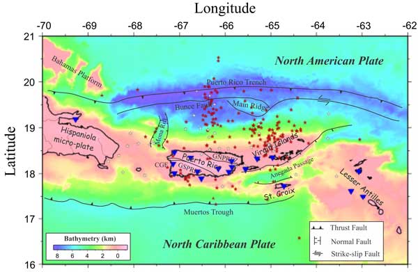
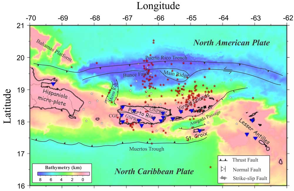
Figure 1: Bathymetry map overlain with tectonic features along the northern margin of the Caribbean Plate (modified after ten Brink et al., 2009; Granja Bruña et al., 2009; ten Brink and López-Venegas, 2012). Black solid lines are fault zones; blue triangles are broadband stations; red stars are earthquakes shallower than 20 km, and white stars are earthquakes deeper than 20 km. GSPRFZ, Great Southern Puerto Rico fault zone; GNPRFZ, Great North Puerto Rico fault zone; CGF, Cerro Goden Fault. Click here or on Figure for enlargement.
Integrated studies of gravity and tomographic data
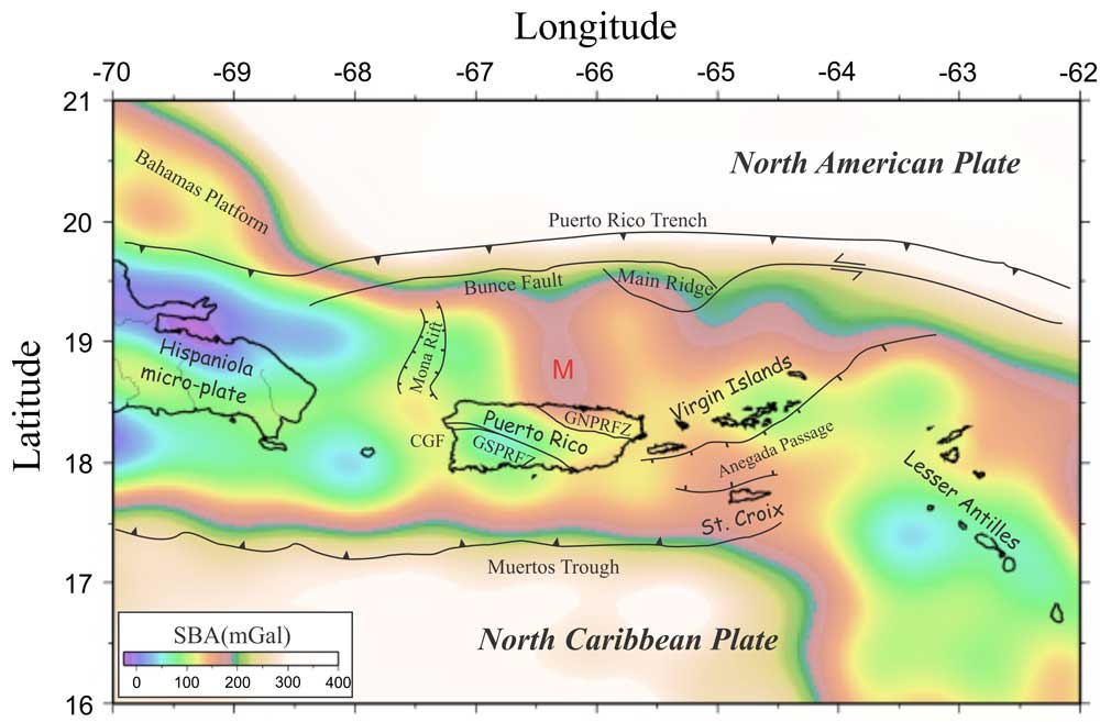
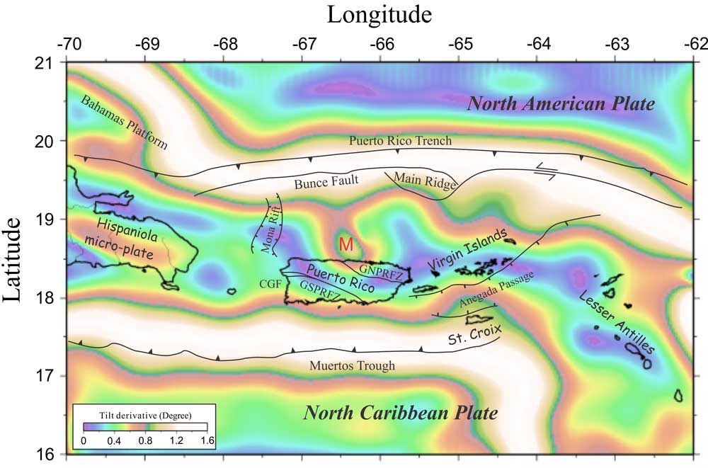
The gravity anomaly data used in this study were extracted from the International Center for Global Earth Models (ICGEM), and our land data (254 stations) that were collected in western Puerto Rico in 2010. Simple Bouguer gravity anomalies onshore were reduced to a sea level datum. Thus, Free-Air anomalies offshore merge smoothly with the simple Bouguer anomalies onshore. The initial simple Bouguer anomaly data are strongly affected by variations in bathymetry. As a result, deep-seated structures are masked by low gravity anomalies offshore. Therefore, we employed a traditional approach to remove the water effect by using bathymetry to apply a Bouguer correction in the marine areas using a density difference of 1.645 g/cm3 for the seawater (2.67–1.025 g/cm3). In addition, in order to highlight the long wavelengths and enhance the large-scale tectonic framework, upward continuation (to 30 km) was utilized (Figure 2). Also in addition, the tilt derivative (TD), an edge detection technique, was employed to detect large-scale geological structures and trends (Blakely & Simpson, 1986) (Figure 3). TD enhances weak anomalies covered by stronger structures. This technique helped define the edges of the subduction zones and plate boundaries that were used in the gravity modelling. As defined by Cooper & Cowan (2006), the TD is the ratio between the total horizontal gradient (THG) and the absolute value of vertical derivative of the potential field.
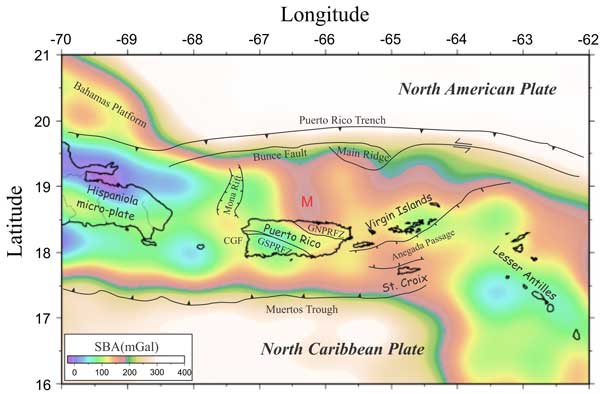
Figure 2: Simple Bouguer anomaly values upward continued to 30 km. GSPRFZ, Great Southern Puerto Rico fault zone; GNPRFZ, Great North Puerto Rico fault zone; CGF, Cerro Goden Fault. Click here or on Figure for enlargement.

Figure 3: Tilt derivative map of the upward-continued simple Bouguer anomaly values. GSPRFZ, Great Southern Puerto Rico fault zone; GNPRFZ, Great North Puerto Rico fault zone; CGF, Cerro Goden Fault. Click here or on Figure for enlargement.
In this study, we used seismic data to image these two subducting slabs together in 3D. The passive seismic data downloaded from the IRIS Data Management Center are distributed across the whole PRVI and the two subducting zones, ranging from 16°N to 21°N in latitude and 70°W to 62°W in longitude (Figure 1). The seismic stations in this area were operated during different time periods and thus the earthquakes whose first arrival travel times span 2000-2010 were picked. Using the 1D velocity model of McCann (2007), the sources were relocated based on the first-arrival-time measurements. This initial, 1D P-wave velocity model for the tomographic calculations consists of three flat-lying layers whose thickness and initial velocity were based on previous 1D models (McCann, 2007; Mendoza & McCann, 2005; Fischer & McCann, 1984).
The initial model was employed for the tomographic calculations of travel times. A second relocation of hypocentres was undertaken in a 3D velocity model due to the importance of accurate determination of earthquake hypocentres. After relocation, the hypocentres that were outside of the grid were deleted. Finally, a total of 217 relocated events were included in the velocity calculation (Figure 1). Our final P-wave velocity model was calculated after 3D inversion using the original 1D starting model. Most geological components can be identified in the P-wave tomography results.
Tomographic cross-section 2D gravity models were constructed along three longitudinal profiles to show the geometry of the main tectonic structures across the PRVI (Figure 4A–C). This integrated modelling was based on bathymetry, gravity values, earthquake hypocentres and 3D tomography results. The locations of the North American Plate, Northern Caribbean Plate and PRVI are determined by tomography results and earthquake hypocentres. To locate better the subducting slabs, we projected three types of earthquake foci onto the profiles. In Figure 4, the earthquakes we relocated are plotted as yellow dots. Green dots are non-relocated magnitude >3 earthquakes from the IRIS database that occurred between 2000 and 2010. Red dots are hypocentres from Meighan et al. (2013). The intracrustal structures were determined by gravity modelling and previous studies (ten Brink, 2005; Officer et al., 1957, 1959; Talwani et al., 1959).
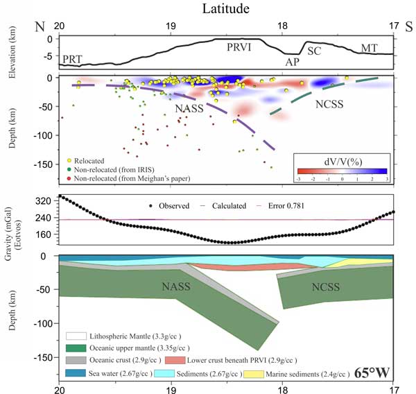
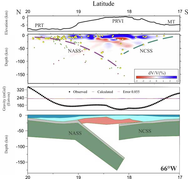
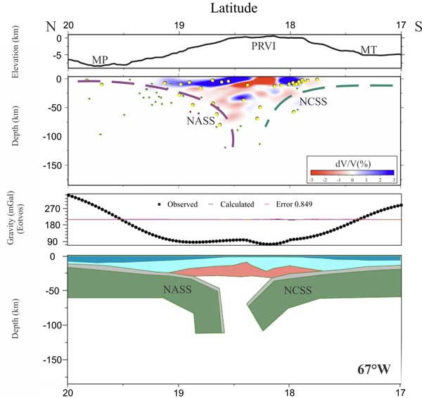
Figure 4. Tomographic modelling results. (A) N to S vertical slice through the P-wave tomographic velocity model and gravity model at 65°W. From top to bottom: bathymetry, P-wave tomography, error of gravity model and 2D gravity model. Purple dashed lines are the top of the North American subducting slab, and green dashed lines are the top of the North Caribbean subducting slab. Yellow dots are relocated earthquakes; green dots are non-relocated earthquakes for IRIS, and red dots are hypocentres from Meighan (2013). (B) Simiar to (A) except N to S vertical slice at 66°W. (C) Similar to (A) except N to S vertical slice at 67°W. PRT, Puerto Rico Trench; PRVI, Puerto Rico Virgin Island; AP, Anegada Passage; MT, Muertos Trough; NASS, North American subducting slab; NCSS, North Caribbean subducting slab; SC, St Croix.
Because bathymetric relief produces a large signal in the traditional Bouguer anomaly values, seawater was assigned a value of 2.67 g/cm3 for the calculation of simple Bouguer anomaly values across the models in Figure 4. Previous studies estimated the Moho depth for the region around Puerto Rico is about 30 km and less than 30 km beneath the Virgin Islands. Thus the Moho depth beneath Puerto Rico in these models decreases eastward (McCann, 2007; Lin & Huerfano, 2011). The architecture of the Moho beneath the PRVI is flat and undeformed in the eastern PRVI (Figure 4).
In the integrated models, the dips of both the North Caribbean subducting slab and North American subduction slab increase westward (Figure 4A–C), which is also suggested by the west-to-east decrease of the onshore–offshore slopes of the PRVI. Because of the steep subduction angle, the Puerto Rico Trench has a steeper slope than the Muertos Trough (Figures 1 and 4A–C) (Gvirtzman & Stern, 2004). We interpret this variation in subduction angle of the North Caribbean subducting slab to be a result of the rollback of the North American subduction slab. The plate kinematics of the PRVI area is controlled by the dynamic movements of the North American subduction slab and North Caribbean subducting slab. The horizontal stresses are different in different locations because of the dip angle variations of two subducting slabs. Thus, dip angle variations of the North Caribbean subducting slab can account for the differential direction and velocity of motion of the PRVI.
Interpretation
Based on the distribution of earthquakes (Figure 1), our interpretation is that the eastern North Caribbean subducting slab has probably been locked because of its continuous extension beneath St Croix but with a low rate of seismic activity. As shown in Figure 4A, the North Caribbean subducting slab overlies the North American subduction slab with a relatively low dip angle in the east. As a result, the movement of the North Caribbean subducting slab creates large stresses along the contact with the eastern PRVI and thus the movement of St Croix Island could have been blocked by the North Caribbean subducting slab. Therefore, the Anegada Passage started rifting due to the relatively stable eastern PRVI and northward extension due to the rollback of the North American subduction slab. In the central portion of the North American subduction slab and North Caribbean subducting slab interaction, the North American subduction slab has a steeper dip, which provides enough space for the North Caribbean subducting slab to move northward without being blocked by the North American subduction slab (Figure 4B). As a result, more shallow earthquakes are generated along the south coast of the PRVI.
With the continuous increase of dip angle of the North Caribbean subducting slab and North American subduction slab westward (Figure 4C), deeper earthquakes are generated beneath the western PRVI and eastern Hispaniola microplate. With respect to the North American subduction slab, it is split into two segments with an opening slab window around the Main Ridge due to its low density (ten Brink et al., 2009) and thus resistance to subduction. This split in the slab is suggested by the seismic quiet zone between the Main Ridge and the north of PRVI and the earthquake clusters on each side (ten Brink, 2005).
The North American subduction slab consists of two segments with different dip angles that are bounded by the Main Ridge (ten Brink, 2005) (Figure 4A–C). Today, the Northern Caribbean Plate, as well as the Hispaniola microplate and PRVI, is generally moving NNE relative to the North American Plate. However, the PRVI is moving more northeasterly and relatively faster than the Hispaniola microplate (Mann et al., 2005a; ten Brink & López-Venegas, 2012; Benford et al., 2012). The direction and rate of the Hispaniola microplate movement are altered due to the existence of the Bahamas Carbonate Platform to the north (Figure 1), which in turn generates resistance to subduction of the North American subduction slab beneath the northern Hispaniola microplate. In addition, we conclude that the faster rate of NE movement in the eastern PRVI relative to the area west of the Mona Rift (Mann et al., 2002; Chaytor & ten Brink, 2010) is causing the rifting along the Mona Rift. The cause of variation is crust of the PRVI moving eastward due to larger scale plate movement to the east of the study area.
Conclusions
We created a 3D tectonic cartoon (Figure 5) to illustrate better the geometric relationships between the Greater Antilles and adjacent areas regarding the variations in subduction between the North American and North Caribbean plates and the resulting kinematic evolution. Our analysis provides details on the geometry of the subducting slab of the eastern North Caribbean subducting slab and its interactions with the PRVI. Our results indicate that the North American subduction slab experiences slab rollback and an increase in the dip of the subduction zone from east to west. These variations cause the dip angle of the North Caribbean subducting slab to also increase westward, which is in agreement with the distribution of earthquake hypocentres.
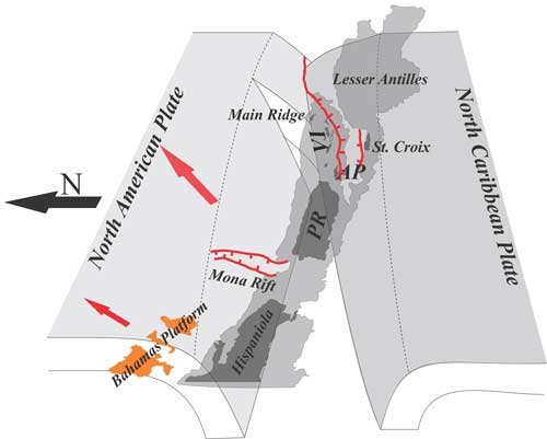
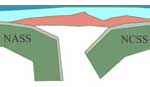
Figure 5. Hypothesized model of the tectonic relationships. The PRVI sits between two subducting slabs. The dip angles of the two subducting slabs increase from east to west. The North American Plate splits in the eastern PRVI (modified after ten Brink, 2005). North arrow is black. Red arrows show the directions of movement for the PRVI and Hispaniola microplate with respect to the North American Plate. The light grey area at the centre is the the region with >2 km bathymetry. PRVI, Puerto Rico Virgin Islands; AP, Anegada Passage.
References
-
Benford, B., DeMets, C., Calais, E. (2012). GPS estimates of microplate motions, northern Caribbean: evidence for a Hispaniola microplate and implications for earthquake hazard. Geophysical Journal International 191, 481–490.
-
Blakely, R.J., Simpson, R.W. (1986). Approximating edges of source bodies from magnetic or gravity anomalies. Geophysics 51, 1494–1498.
-
Chaytor, J.D., ten Brink, U.S. (2010). Extension in Mona Rift, Northeast Caribbean. Tectonophysics 493, 74–92.
-
Cooper, G.R.J., Cowan, D.R. (2006). Enhancing potential field data using filters based on the local phase. Computers & Geosciences 32, 1585–1591.
-
Ficher, K.M., McCann, W.R. (1984). Velocity modeling and earthquake relocation on the Northeast Caribbean. Bulletin of the Seismological Society of America 74, 1249–1263.
-
Granja Bruña, J.L., tenBrink,U.S., Carbó-Gorosabel, A., Muñoz-Martín,A., Gómez Ballesteros, M. (2009). Morphotectonics of the central Muertos thrust belt and Muertos Trough. Marine Geology 263, 7–33.
-
Gvirtzman, Z., Stern, R.J. (2004). Bathymetry of Mariana trench-arc system and formation of the Challenger Deep as a consequence of weak plate coupling. Tectonics 263, 7–33.
-
Jolly, W.T., Lidiak, E.G., Dickin, A.P. (2007). Bimodal volcanism in northeast Puerto Rico and the Virgin Islands (Greater Antilles Island Arc): genetic links with Cretaceous subduction of the mid-Atlantic ridge Caribbean spur. Lithos 103, 393–414.
-
Lin, G.Q., Huerfano V.A., (2011). Improving three-dimensional seismic velocity models and earthquake locations for Puerto Rico and the US Virgin Islands: collaborative research between University of Miami and University of Puerto Rico in Mayaguez. US Geological Survey External Research No. G10AP00020 and G10AP00021.
-
Mann, P., Calais, E., Ruegg, J.C., DeMets, C., Jansma, P.E., Mattioli, G.S. (2002). Oblique collision in the northeastern Caribbean from GPS measurements and geological observations. Tectonics 21, 7-1–7-26.
-
Mann, P., Prentice, C.S., Hippolyte, J.C., Grindlay, N.R., Abrams, L.J., Dávila, D.L. (2005). Reconnaissance study of late quaternary faulting along Cerro Goden fault zone,western Puerto Rico. GSA Special Papers 385, 115–13.
-
McCann, W.R., (2007). Improving the seismic hazard model for Puerto Rico: a reliable microearthquake catalog through seismic velocity modeling and microearthquake joint location. US Geological Survey External Research No. 04HQGR0015.
-
Meighan, H.E., Pulliam, J., ten Brink, U., López-Venegas, A.M. (2013). Seismic evidence for a slab tear at the Puerto Rico Trench. Journal of Geophysical Research: Solid Earth 118, 2915–2923.
-
Mendoza C., McCann, W.R., (2005). Improving the seismic hazard model for Puerto Rico through seismic tomography and a reliable microearthquake catalog with recalculated magnitudes and calibrated hypocentral error estimates. US Geological Survey External Research No. 05HQGR001220.
-
Officer, C., Ewing, J., Hennion, J., Harkrider, D., Miller, D. (1959). Geophysical investigations in the eastern Caribbean—summary of the 1955 and 1956 cruises. Physics and Chemistry of the Earth 3, 17–26.
-
Officer, C.B., Ewing, J.I., Edwars, R.S., Johnson, H.R. (1957). Geophysical investigations in the Eastern Caribbean: Venezuelan Basin, Antilles Island Arc, and Puerto Rico Trench. Geological Society of America Bulletin 68, 359–378.
-
Talwani, M., Sutton, G.H., Worzel, J.L. (1959). A crustal section across the Puerto Rico Trench. Journal of Geophysical Research 64, 1545–1555.
-
ten Brink, U.S. (2005). Vertical motions of the Puerto Rico Trench and Puerto Rico and their cause. Journal of Geophysical Research 110, B06404.
-
ten Brink, U.S., López-Venegas, A.M. (2012). Plate interaction in the NE Caribbean subduction zone from continuous GPS observations. Geophysical Research Letters 39, L10304.
-
ten Brink, U.S., Stephen, M., Granja Bruña, J.L. (2009). Bivergent thrust wedges surrounding oceanic island arcs: insight from observations and sandbox models of the northeastern Caribbean plate. GSA Bulletin 121, 1522–1536.
-
van Gestel, J.P., Mann, P., Dolan, J.F., Grindlay, N.R. (1998). Structure and tectonics of the upper Cenozoic Puerto Rico Virgin Islands carbonate platform as determined from seismic reflection studies. Journal of Geophysical Research 103, 30505–30530.
last updated 17th
September, 2015 |