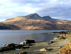
 Figure 1. Location of
Mull at the SW end of the Great Glen.
Figure 1. Location of
Mull at the SW end of the Great Glen. |
The
island of Mull, located on the Great Glen strike-slip
fault (Figure 1), is the site of one of the
Scottish Tertiary central volcanoes which form
part of the North Atlantic Igneous Province.
Volcanic activity on Mull started at about 61
Ma with the eruption of fissure-fed lava flows
that built a plateau-lava sequence over 1 km
thick (Figure 2). |
Magmatism
then focused into a central volcanic system,
the remains of which are represented by the
intrusive central complexes. Three such intrusive
centres are recognised on Mull (Figure 3). The
locus of activity migrated northwards with time
and the magma composition changed from dominantly
basic in Centre 1 to dominantly silicic in Centre
3. The plutonic complexes were emplaced at high
levels largely through caldera collapse and
ring-dyke formation. The youngest of these ring
dykes (Loch Ba) was emplaced at about 58 Ma. |
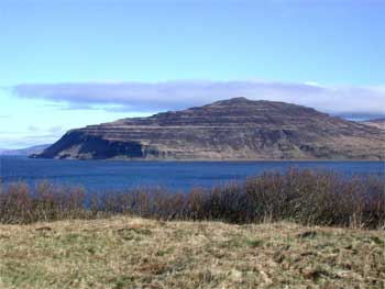
Figure
2. The Mull plateau-lava sequence exposed in
The Wilderness, seen here looking northwards
from the W end of the Ross of Mull peninsula.
|
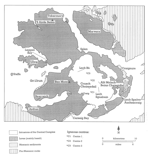
Figure 3. Outline
geological map of Mull (from Emeleus, C.H. & Gyopari,
M.C. (1992). British Tertiary Volcanic Province. Geological
Conservation Review Series. Chapman & Hall, 259
pp.).
Basement rocks are well
exposed on Mull and give a clear picture of earlier
geological events. Proterozoic Moine schists are the
oldest rocks exposed on the island though Archaean
Lewisian Gneiss is exposed on the island of Iona (Figure
1). In SW Scotland the Great Glen fault separates
Moine schists from the younger Dalradian metasediments,
and small outcrops of Dalradian rocks are found in
the SE part of Mull. At the end of the Caledonian
orogeny (~410 Ma) a small granite pluton was emplaced
into the Moine rocks on what is now the tip of the
Ross of Mull peninsula (Figure 1). Erosion of the
Caledonian mountain belt led ultimately to the deposition
of Triassic conglomerates and marls in an arid environment
in intermontane basins. These are well exposed on
the coast of Mull at Gribun (Figure 3). The formation
of these basins marks the beginning of an extensional
episode that led to the deposition of the marine Jurassic
and Cretaceous sediments exposed at Gribun and Carsaig
Bay (Figure 3). Regional uplift preceding the onset
of Tertiary magmatism brought marine sedimentation
to an end. The earliest Tertiary lava flows were erupted
on a land surface composed of the eroded remains of
Cretaceous chalk deposits.
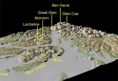
Summary Itinerary
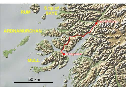
Figure 4. The route
from Fort William to Mull.
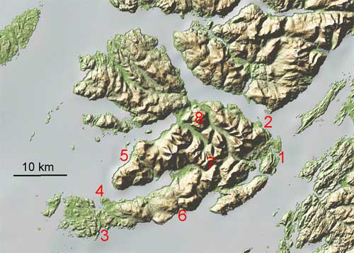
Figure 5. The locations
to be visited during the field trip.
Friday, 2nd:
Travel from Fort William to Craignure (where we will
be staying) in Mull (Figure 4). We shall drive SW
along the Great Glen and cross it at the Corran Ferry;
then over Morvern and across to Mull on the Lochaline
Ferry.
Afternoon:
Grass Point and Craignure. Grass Point (locality 1
on Figure 5) provides excellent exposures of a steeply
dipping succession of Mesozoic and Tertiary sedimentary
rocks and Tertiary lava flows. The folding responsible
for the dip was caused by the intrusion of the Centre
1 magma. The timing can be demonstrated at Craignure
(2) where a gently dipping and undeformed silicic
cone sheet belonging to Centre 2 can be seen cutting
deformed Mesozoic sedimentary rocks.
Saturday, 3rd:
A trip to the end of the Ross of Mull Peninsula in
the SW part of the island to examine some of the basement
rocks at Ardalanish Bay (3). Here Proterozoic Moine
schists are cut by a Caledonian (410 Ma) granite (Figure
6). To Ardtun (4) in the afternoon to see columnar
jointed basalt flows with fluvial interbeds low in
the plateau sequence. The interbeds consist of shales
with fossil plants, and conglomerates containing Cretaceous
flint pebbles. The presence of flint pebbles proves
uplift and erosion of marine Cretaceous chalk shortly
before eruption of the first plateau lava flows.
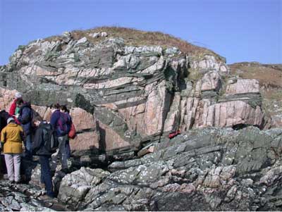
Figure 6. Rafts of Moine
metasediment in margin of Ross of Mull granite |
Sunday,
4th: Morning: Mesozoic sedimentary
rocks at Gribun (5). The succession at Gribun
consists of Triassic conglomerate and marls
deposited on Moine metasediments (Figure 7).
Afternoon: exposures at Carsaig (6) extend the
succession through the Jurassic and into remnants
of Cretaceous marine sandstone and chalk overlain
by Tertiary plateau lava flows. Return to Craignure
across the island and stop to see the Centre
1 gabbros (7). These are layered in places and
show remarkable “sedimentary” structures. |
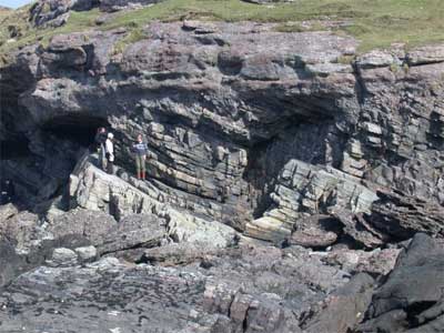
Figure 7. Triassic conglomerate
on Moine metasediments at Gribun |
Monday, 5th: The Centre
3 silicic ring dyke at Loch Ba (8), which
represents the last major igneous event in
the evolution of the Mull central volcano
(Figure 8). Centre 3 is dominantly silicic
(granophyre and rhyolite). This part of the
excursion will be fairly strenuous and requires
good walking boots and a reasonable degree
of fitness.
Tuesday, 6th: Depart Mull.
The minibus will return to Edinburgh via Glasgow
and we will be able to stop at the airports.
Accommodation: Isle of Mull
Hotel, Craignure. The inclusive cost of the
excursion will be announced later.
|
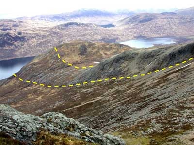
Figure 8. The Loch Ba ring
dyke (between dashed lines) cutting centre 3
granophyre (in foreground). |
Literature: Below are listed
maps and books relating to Mull and its geology.
Topographic maps can be obtained through most
booksellers or from Edward
Stanford Ltd., 12-14 Long Acre, London
WC2E 9LP. Publications (maps, memoirs etc)
of the British
Geological Survey can be purchased from
BGS Keyworth, Nottingham NG12 5GG, BGS, Murchison
House, West Mains Road, Edinburgh EH9 3JW,
the Natural History Museum, Earth Sciences
Galleries, South Kensington, London or through
approved stockists. (NB. BGS publications
required for educational purposes and ordered
through an educational establishment may attract
a considerable discount.)
|
Maps:
Ordnance Survey
topographic maps:
1:50,000 Sheets 48 and 49 cover Mull.
Geological maps:
1:50,000 British Geological Survey Scotland
Sheet 44 (Solid) covers most of Mull.
Geological publications:
Bell, B. R. and Williamson, I. T. 2003. Tertiary igneous
activity. In Trewin, N H (editor) The Geology
of Scotland (4th Edition). The Geological Society:
London
Emeleus, C. H. and Bell,
B. R. (publication due 2005). British Regional
Geology: the Palaeogene volcanic districts of Scotland
(4th Edition) London: HMSO for the British Geological
Survey.
JGF 29th March, 2005