Summary
Itinerary
Sunday 21st
Arrive Mallaig late afternoon/evening, stay
overnight at the Marine Hotel.
Monday 22nd
09.45 (latest): assemble at the Caledonian Macbrayne
pier next to the Small Isles ferry “Loch
Nevis”, for a 10.15 departure.
Arrive Rum 12.45
and walk to Kinloch Castle (c 1.5 km; your baggage
will be transported by Land Rover). Local geology
in afternoon.
Tuesday 23rd
– Thursday 25th Day long excursions
designed to illustrate most aspects of the Paleocene
igneous geology of Rum (see provisional summary below).
Friday 26th
Features (geological and otherwise) around Kinloch
will be examined in the morning.
Departure
from Rum: If you wish, you may board the ferry
at 14:15. If you do this you should be at the slipway
by 13:45. The ferry will go to the Isle of Canna and
then return to Rum at 16:35. If you want to spend
a little time on Canna, you can take this option for
a small additional ferry charge. People who would
prefer to spend more time on Rum may board the ferry
when it returns to Rum at 16:35, and then sails straight
to Mallaig. Be sure to be there well in advance of
16:35 to allow time for boarding.
Luggage must be ready
well in advance, to be loaded onto the Land Rover
going to the slipway. You must be sure that
you check your own luggage onto the ship.
Arrive Mallaig
17:55. Transport will be arranged to take the group
from there to Ft. William.
If you are planning
to stay a further day on Rum privately, a Saturday
morning boat from Rum will get you to Mallaig at about
13:00 hours, with ample time to get the afternoon
train to Ft. William. Please note that the charge
for the main excursion does not cover the additional
costs arising from a further day's accommodation or
independent travel from Rum to Ft. William.
Costs
The inclusive cost of
the excursion (Mallaig –> Rum –>
Mallaig –> Ft. William, including B&B
in Mallaig 21st August) is Ł270.
General
 |
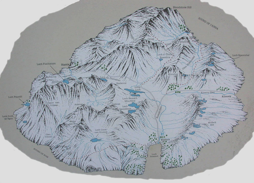
The
Isle of Rum is the largest of the Small Isles
in the Inner Hebrides, NW Scotland. It a National
Nature Reserve, owned and managed by Scottish
Natural Heritage (SNH) (www.snh.org.uk).
In addition to spectacular geology, the island
is noted for its herd of red deer (the subject
of a long-term study), feral goats, plant life,
birds (Rum was used as the base for the reintroduction
of the Sea Eagle to the Hebrides), and insects
(including the midge).
Rum has a population
of about 20, the majority living at Kinloch
where the SNH has its office and staff quarters,
and where there is a shop/post office and public
telephone (NB: mobile/cell phone reception
is poor except on the extreme east coast of
the island). The party will stay at Kinloch
Castle, an Edwardian country house/shooting
lodge. |
The island is served
by a ferry service (foot passengers only) from the
fishing port of Mallaig, which is connected by road
and railway to Fort William (45 miles) and Glasgow
(150 miles), and by road to Inverness (110 miles).
The nearest airports are at Glasgow and Inverness.
There is also a regular vehicle ferry connection (c.
40 minutes) between Mallaig and Armadale on the Isle
of Skye. Ferry services are operated by Caledonian
MacBrayne (www.calmac.co.uk)
and train services by Scotrail (http://www.firstgroup.com/scotrail/).
|
|
Field
work on Rum commonly involves walking
in the rain and wind, over rough, damp
ground, so please come prepared! It is essential
to have suitable walking boots for day use and
adequate waterproof clothing. Temperatures in
August are generally in the range 15 –
18oC. All excursions will be
on foot (the SNH Land Rovers are
exclusively for the use of their staff),
with distances up to about 12 km. There are
no paved roads on Rum, only rough tracks and
a few paths. Most excursions will involve cross-country
walking over wet ground, climbing up to about
700 m (c. 2200 feet) elevation on one day. |
The island is well known
for the ferocity of its midges. If there is the slightest
breeze these are generally not a problem, but they
can be very trying on still, humid days. So, bring
your preferred repellant for none may be available
on the island. Ticks occur in the areas frequented
by deer and goats. Your best protection against both
is to wear long trousers and long sleeved shirts,
and at the end of the day make sure that no ticks
are attached to you. Unlike on the other large islands
and the Scottish mainland, there are no snakes on
Rum.
Travel and Accommodation
Unless you inform us
to the contrary it will be assumed that everyone will
arrive in Mallaig on the afternoon or evening of Sunday
21st (the last train is due in to Mallaig
at about 23.30, having departed Glasgow ca. 18.00).
The party will stay overnight at the Marine Hotel
which adjoins the railway station. Cars may be left
in the long-term car park on the west side of the
road from Ft. William (A830), adjacent to the railway
station (the car park was free in 2004). Be sure to
lock your car securely and don't leave any coats or
bags, etc visible. Last minute shopping can
be done on Monday morning, the shops, banks (with
cash machines) and the post office are close to the
Marine Hotel.
The Caledonian MacBrayne
ferry “Loch Nevis” departs from
a berth close to the Skye vehicle ferry, a few minutes
walk from the hotel. We have already reserved return
tickets for everyone. You must get to the ferry about
30 minutes before departure (which is scheduled
for 10:15 ) in order to give time for baggage
to be assembled and loaded onto the ferry. The ship
is due to arrive at the Rum slipway at 12:45. There
is a cafeteria onboard which will give a chance for
you to buy a mid-day meal or snack (the first meal
on Rum will be supper at about 19:00).
The party will stay
in the Kinloch Castle hostel. You will share accommodation
in rooms for 2, 3 or 4 persons. Please note that this
is not a hotel and some facilities (e.g. for
washing) may be limited, especially if the hostel
is full. We shall be provided with breakfast, a packed
lunch and dinner (soft drinks, wine, beer will
be available but must be paid for individually).
Please give the organizers advanced notice of any
special dietary requirements. It should also be possible
to make tea or coffee in the self-catering kitchen.
There is a strictly enforced ban on smoking in
the hostel (except in one designated common room)
or castle courtyard. Please observe this.
There is a small shop/post
office which is usually quite well stocked with snacks
and drinks (alcoholic and otherwise). The shop is
generally open between about 17:30 – 19:30.
A limited selection of postcards may be available
and postcards may also be on sale in the Castle, along
with Scottish Natural Heritage literature about Rum.
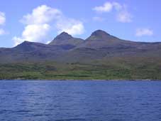
On Friday 26th
the ferry departs for Mallaig at 14:15. The journey
is normally via the island of Canna, west of Rum,
and usually provides good views of NW Rum and the
Skye Cuillin. You may also board it at 16:35 when
the boat returns to Rum. Arrival at Mallaig is scheduled
for 17:55. As this gives a very tight connection with
the last train to Ft. William (scheduled to leave
at 18:15), we will arrange vehicular transport to
Ft. William for the group as necessary. The official
end to the excursion will be at Mallaig. Individuals
should have made their own arrangements for accommodation
for the night of 26th August.
NB: Ferry sailings
can be delayed by adverse weather conditions. This
rarely happens during the Summer and delays are less
frequent since the completion of the new slipways
on Rum and the other islands. Prior to 2004 passengers
were transported between the ship and shore
by a small motor boat.
Summary of the Geology
and a provisional list of excursions.
The Paleocene Rum Central
Igneous Complex (c. 60 Ma) is situated on a
ridge of Archean Lewisian gneiss and sandstones of
the Mid-Proterozoic Torridon Group, bounded to the
east and west by basins filled with Mesozoic sedimentary
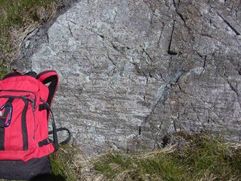
rocks and Paleocene basalt lavas. On Rum, the coarse-
to medium-grained red Torridon sandstones form the
country rocks to the Paleocene Igneous Complex. The
sandstones cut by numerous NW- to N- trending (predominantly)
basaltic dykes of Paleocene age and, in NW Rum are
overlain by Triassic sandstones and lavas of Paleocene
age. Relic masses of Jurassic sedimentary rocks and
Lewisian gneiss occur within the central complex,
together with Torridonian sandstones and Paleocene
basaltic lavas.
The Rum Central Igneous
Complex was formed in two distinct stages:
During Stage 1
a major arcuate fault system (the Main Ring Fault)
developed, which encompasses most of the intrusive
and extrusive igneous activity. Central uplift on
the ring faults brought masses of Lewisian gneiss
and the basal members of the Torridon Group, to the
present erosional levels, while later subsidence brought
down Jurassic sedimentary rocks and Paleocene basaltic
lavas. Magmas of mixed basaltic and rhyodacitic compositions
intruded along the ring faults, and also erupted as
ash flows which accumulated in a caldera bounded by
the ring faults. The flows buried contemporaneous
coarse breccias (predominantly of Torridon Group rocks)
resulting from the collapse of the caldera walls.
Somewhat later, several granites were intruded, including
the Western Granite which forms much of western Rum.
During Stage 1, the country rocks were strongly domed
over the central complex and there is evidence that
large masses of sandstone slid off the dome.
Stage 2 commenced
with the intrusion of many basaltic dykes and a suite
of basaltic cone-sheets. These were followed by the
emplacement of the Rum Layered Suite (gabbros, troctolites
and feldspathic peridotites) that now forms the high
ground of central Rum. In eastern Rum, these mafic
and ultramafic rocks form prominent, gently-dipping
layers (generally termed “Units”) and
comprise the Eastern Layered Intrusion (or “Series”).
A number of processes operated during the formation
of the layered structures, including crystal fractionation
and the intrusion of sheet-like bodies. Layered rocks
also occur in SW Rum (the Western Layered Intrusion).
The two areas of layered rocks are separated by the
Central Intrusion, a N-S belt of breccias composed
of blocks and megablocks of bytownite troctolite and
feldspathic peridotite enclosed in matrices of similar
compositions. The Central Intrusion is regarded as
the feeder zone for the layered rocks. It is located
along a major N-S fracture, the Long Loch Fault. Numerous
sheets and plugs of gabbro and feldspathic peridotite
intrude the layered rocks and plugs are common throughout
the country rocks. A few dykes, including rare picrites,
intrude the Rum Layered Suite.
A major volcanic edifice
likely built up during stages 1 and 2, but vigorous
erosion soon reduced the central complex to a hilly
landscape, at much the level of the present land surface.
The evidence for this is found in NW Rum where the
Western Granite and sandstones of the Torridon Group
are overlain by predominantly basaltic lava flows
(c. 60 Ma) with intercalated fluviatile conglomerates.
The lava flows and conglomerates, which belong to
the Canna Lava Formation, have buried and preserved
a hilly landscape dissected by steep-sided valleys
that drained central Rum. The conglomerates contain
abundant clasts of red sandstone and gneiss, together
with rhyodacite, granite, troctolite and gabbro, all
clearly derived from the central complex. Flows and
conglomerates belonging to the Canna Lava Formation
form the nearby islands of Canna and Sanday and are
part of the Skye Main Lava Group of SW Skye where
they are cut by gabbros of the Skye Cuillin Centre.
The Rum central complex (60.5 Ma) was clearly dead
and thoroughly dissected before the presently-exposed
member of the Skye central complex were intruded (at
c. 59 Ma).
Rum was almost completely
covered by the major Pleistocene ice sheet sourced
in mainland Scotland and, at a later stage, it supported
a local ice cap with several valley glaciers. The
ice had gone by about 10,000 BP and there is evidence
that Man arrived fairly soon thereafter: at Kinloch
a site excavated a few years ago has yielded implements
made from the bloodstone found in the lavas of NW
Rum. Remains from this site have been dated at about
8,500 BP.
Provisional excursions
(N.B. order and content subject to weather!):
(i) A
half day will be spent around Kinloch, on
the sandstones of the Torridon Group and the
numerous minor intrusion. The latter include
basaltic sheets and dykes, and several plugs
or feldspathic peridotite and gabbro.
(ii) This
will be concerned with the rocks of Stage
1 exposed in Coire Dubh and on the low
hills south of Kinloch (Cnapan Breaca, Meall
Breac and Am Mam). The traverse, from Kinloch
into Coire Dubh to the south, will take us
across in situ Torridon Group rocks
to the Main Ring Fault, then onto caldera
breccias, and ash flows and small intrusions
of rhyodacite (with evidence of mixing of
basaltic and rhyodacitic magmas). On Am Mam,
a distinctive intrusive breccia is seen to
pre-date intrusive rhyodacite.
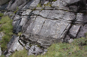
|
 Fiamme at the base of rhyodacite ash-flow
sheets, Coire Dubh and Meall Breac.
Fiamme at the base of rhyodacite ash-flow
sheets, Coire Dubh and Meall Breac. |
 Layered ultrabasic rocks with sedimentary
structures, East slope of Hallival.
Layered ultrabasic rocks with sedimentary
structures, East slope of Hallival. |
(iii) The
aim will be to examine members of the Eastern
Layered Intrusion. Using the same route as at
the start of excursion (i), we shall continue
south to the layered rocks (“Units 7,
8”) in the back of Coire Dubh where thin
anorthosite and chrome-spinel-rich layers occur,
then over ledges formed by resistant bytownite
troctolite (“allivalite”) layers
to a shelf (“Unit 9”) about 1 km
N of Hallival. Here layered structures have
been variously ascribed to sedimentary loading
in the magma chamber or to metasomatic replacement.
Continuing uphill to the ridge NNW of Hallival
there are good examples of chromite seams developed
between major layers (“Units 11/12”)
and, continuing to Hallival summit (722 m),
of extensive slumping and deformation in the
“allivalite” layers. |
On
a clear day the view from Hallival summit is magnificent:
it extends from Ardnamurchan in the SE, east to the
isles of Eigg and Muck with the Western Highlands
beyond (and with Ben Nevis in the far distance), and
north to the Paleocene Skye Central Igneous Complex
and the Torridon Group sandstone hills of Applecross.
The Outer Hebrides occupy the far western horizon.
After a steep descent to the col between Hallival
and Askival, return over allivalite shelves, some
of which expose large xenoliths of basic granulites,
interpreted to be thermally metamorphosed lavas from
the pre-Rum Central Complex Eigg Lava Formation.
(iv) Continued
examination of Stage 2 rocks, now belonging
to the Central Intrusion: from Kinloch, take
the rough road west and SW for about 4 km to
the low ridge immediately west of the Long Loch.
The ridge exposes superb layered structures
attributable to magmatic sedimentation proceses
during formation of the “allivalites”
and feldspathic peridotites. Continuing beyond
the S end of the Long Loch, spectacular breccias
contain large blocks of layered ultramafic rocks
in feldspathic peridotite with wildly disturbed
layering. |
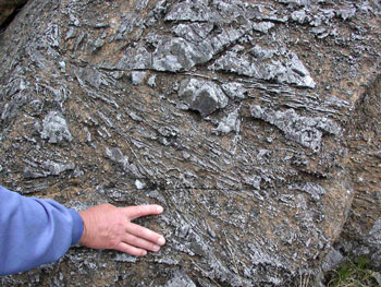 Outcrop in Central Layered Series showing
harrisitic olivine (in-situ growth).
Outcrop in Central Layered Series showing
harrisitic olivine (in-situ growth). |
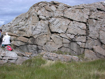 Ultrabasic Breccias, of central and SW Rum
 |
In the latter
part of this day there are the options of
(a) continuing to the Western Layered Intrusion
at Harris Bay (a longish walk), where the
complicated contact with the Western Granite
is well exposed, or (b) of examining the post-central
complex lavas and conglomerates around Fionchra
(another longish walk).
(v) There
might be an opportunity for a quick reappraisal
of rocks from Excursion 1 in Coire Dubh
(returning to Kinloch by 12.30 at the latest),
or of taking it easy and possibly having a
guided tour of the Castle (charge c. Ł3)
|
Literature
Below are listed a number
of maps and books relating to Rum and its geology.
Topographic maps can be obtained through most booksellers
or from Edward Stanford Ltd., 12-14 Long Acre, London
WC2E 9LP (www.stanfords.co.uk).
SNH publications (including the 1:20,000 geological
map) are obtainable on Rum. Publications (maps, memoirs
etc) of the British Geological Survey (www.bgs.ac.uk)
can be purchased from BGS Keyworth, Nottingham NG12
5GG, BGS, Murchison House, West Mains Road, Edinburgh
EH9 3JW, the Natural History Museum, Earth Sciences
Galleries, South Kensington, London or through approved
stockists. (NB. BGS publications required for educational
purposes and ordered through an educational establishment
may attract a reasonable discount.)
Maps
Ordnance Survey
topographic maps
1:50,000 Landranger
series, Sheet 33 Rum and Eigg, Ł6.49
1:25,000 Explorer series:
Sheet 397, Rum, Eigg, Muck, Canna and Sanday,
Ł7.49
Geological maps
1:50,000 British Geological
Survey Scotland Sheet 60, Rum (Solid &
Drift) (1994) Ł10.
1:20,000 Scottish Natural
Heritage RUM-Solid Geology. (SNH, Rum; Ł5 –
available on Rum)
Geological publications
(i) Rum (A guide
to the excursions will be provided on arrival)
Emeleus, C.H. 1997.
Geology of Rum and the adjacent islands. Memoir
of the British Geological Survey, Sheet 60 (Scotland)
Ł35.
Emeleus, C.H. and Forster,
R.M. 1979. Guide to the Tertiary Igneous Rocks
of Rhum. Nature Conservancy Council, Peterborough.
(Obtainable from SNH office on Rum, Ł3)
(ii) Palaeogene
igneous rocks of NW Scotland, including Rum
Bell, B R and Williamson,
I T. 2003. Tertiary igneous activity. In Trewin,
N H (editor) The Geology of Scotland
(4th Edition). The Geological Society: London
Emeleus, C H and Bell,
B R. 2005. British Regional Geology: the Palaeogene
volcanic districts of Scotland (4th Edition) London:
HMSO for the British Geological Survey. (Price to
be announced.) This book is now hot off the printing
press and copies will be made available for purchase
at the Ben Nevis Hotel during the meeting.
CHE 28th February,
2005
details of logistics updated by GRF 12th August,
2005