The Palaeogene Skye
Lava Field covers most of north and west-central Skye
(Figure 1). The lavas were erupted predominantly in
a terrestrial environment, with only minor occurrences
of pillowed flows, hyaloclastites, and related hydromagmatic
phenomena. Eruption of the lavas was mainly via fissure
systems, now represented by the NW-trending Skye Dyke
Swarm and the orthogonally oriented Scalpay and Glen
Brittle subswarms. Locally, eruptions of silicic magmas
produced accumulations of ignimbrite and other silicic
tuffs. The erosional remnants of the lava field have
developed a trap (step-like) topography and, in places,
give rise to spectacular coastal cliffs, especially
in west-central Skye between Talisker Bay and Loch
Brittle (Figure 2).
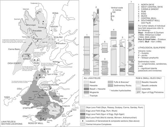
Figure 1: Sketch map
showing the distribution of, and inferred relationships
between the Palaeogene lava fields of the Hebridean
Igneous Province and representative generalized vertical
sections through the Hebridean lava fields (from Bell
& Williamson 2002). Click
here or on map for enlarged PDF version.
|
|
The
next major period of magmatic activity is represented
by the Skye Central Complex. Four phases are
recognised, commencing with the ultrabasic and
basic rocks that constitute the Cuillin Centre
(Figure 3). Layered and unlayered gabbros, troctolites
and peridotites form the mountainous area referred
to as the Cuillin Hills, rising, in many places,
to almost 1000 m above sea level (Figure 4).
A number of units have been identified within
the complex and are typically ring-shaped in
plan. Where layering is present, as defined
mainly by modal variation, it dips inwards,
towards a focal point at depth in the vicinity
of Meall Dearg at the southern end of Glen Sligachan.
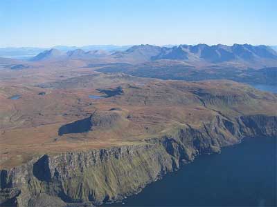
Figure 2: The Skye Lava
Field, Preshal Beag, looking east towards the
Cuillin Hills.
|
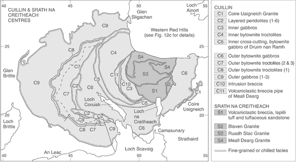
Figure 3: Geological
map of the Cuillin and Srath na Creitheach centres (from
Bell & Williamson 2002).

Figure 4: The southern
Cuillin Hills, looking NW.
Inward-dipping, late-stage
sheets of relatively fine-grained olivine tholeiite
transect the dominant coarse-grained lithologies of
the centre, certain of which are thin and have a common
focal point at depth and are referred to as cone-sheets.
In addition, a large number of dykes from the regional
swarm transect the centre. Consequently, due to the
effects of differential weathering and erosion, the
Cuillin Hills have a very irregular, serrated, topography,
unique within Scotland.
The three younger Red
Hills granite centres - Srath na Creitheach, Western
Red Hills and Eastern Red Hills - constitute the other
main phases of subvolcanic activity within the Skye
Central Complex (Figures 3 & 5). Each of these three
granite centres comprises a number of compositionally
distinct intrusions, often with clear evidence of their
order of emplacement and their three-dimensional geometry.
Because the granite centres were emplaced after the
intrusion of the cone-sheets that cut the various units
of the Cuillin Centre, and after the intrusion of the
majority of the dykes of the regional swarm, they give
rise to a contrastingly smooth, generally rounded, although
still elevated, topography (Figure 6).
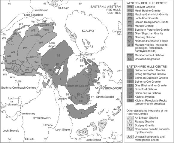
Figure 5: Geological
map of the Western Red Hills and Eastern Red Hills
centres (from Bell & Williamson 2002).
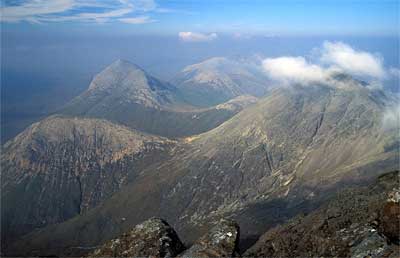
Figure 6: The
Western Red Hills Centre, looking north from
the Bla Bheinn ridge. |
The
relatively shallow emplacement depth(s) of the
Cuillin Centre and the granite centres, estimated
to have been in the order of 1-2km, into fractured
and water-filled rock, led to the development
of hydrothermal metamorphic aureoles adjacent
(and presumably above) the intrusive units.
Uplift, intense
weathering and erosion during the Late Tertiary,
in a warm temperate climate, removed a significant
proportion of the lava field and exhumed the
subvolcanic intrusions. Glaciation over the
last few tens of thousands of years have produced
the landforms that control the spectacular topography
of the island. |
Summary Itinerary
Friday, 2nd:
Travel from Fort William to Skye (2 – 3 hours).
Local geology in the afternoon. Depends upon where
we are staying, but most likely in the Royal Hotel,
Portree.
Saturday, 3rd:
Excursion to investigate the architecture of the flood
lava sequence of west-central Skye. Traverse from
Talisker Bay, south to the prominent summit of Preshal
Beg. Spectacular exposures of: sheet lavas (basalt
through to trachyte), examples of palaeo-topography/landscape,
inter-lava sedimentary units, biotite-anorthoclase
tuffs, intra-canyon flows, pillowed lava facies, columnar
joint development, and formation of present-day "inverted
topography".
Sunday, 4th:
Excursion to investigate the gabbroic and peridotitic
layered rocks of the Cuillin Centre. The journey to
Loch Coruisk will be by boat (the Bella Jane, leaving
from the village of Elgol on the Strathaird peninsula).
This 45-minute trip will take us under the impressive
Munros (Scottish summits > 3,000 feet) of the Southern
Cuillin. From the landing point, it is a short walk
to the freshwater Loch Coruisk, one of the most spectacular
views in Scotland – in good weather or bad!
We will then spend the day either in and around Loch
Coruisk and in An Garbh-coire examining the layered
rocks and returning by boat to Elgol, or, if desired,
undertaking a traverse to the margin of the complex,
around the south side of Sgurr na Stri to Camasunary
Bay, and then out across the flood lava sequence of
Strathaird to the public road.
Monday, 5th:
Excursion to investigate the shallow-level silicic
plutons, stocks and a ring-dyke of the Western Red
Hills Centre. A traverse south along Glen Sligachan
will pass over hydrothermally altered, amygdaloidal
basalt lava country-rocks. The subsequent traverse
up Marsco (summit 736 m a.s.l.) via Harker’s
Gully will allow examination of a variety of granites
and microgranites, a hybrid ring-dyke comprising basic
(ferrodiorite), silicic (porphyritic felsite) and
mixed-magma ("marscoite") components. Xenoliths
of basement gneiss within the ferrodiorite unit are
exposed at the base of the gully and the complete
sequence of lithologies is exposed at higher levels,
for example at the Shelter Stone. Weather permitting,
we will go to the summit of Marsco, where an early
gabbro sheet caps the mountain. From here, the views
are spectacular in all directions.
Tuesday, 6th:
Depart Skye.
Accommodation:
Probably at the Royal Hotel, Portree.
Cost: The
inclusive cost of the excursion will be announced
later.
Literature:
Below are listed maps and books relating
to Skye and its geology. Topographic maps can be obtained
through most booksellers or from Edward
Stanford Ltd., 12-14 Long Acre, London WC2E 9LP.
Publications (maps, memoirs etc) of the British
Geological Survey can be purchased from BGS Keyworth,
Nottingham NG12 5GG, BGS, Murchison House, West Mains
Road, Edinburgh EH9 3JW, the Natural History Museum,
Earth Sciences Galleries, South Kensington, London
or through approved stockists. (NB. BGS publications
required for educational purposes and ordered through
an educational establishment may attract a considerable
discount.)
Maps:
Ordnance Survey
topographic maps:
1:50K Landranger series, Sheet 32 South Skye, £6.49
1:25K Explorer series: Sheet 411, Skye Cuillin Hills,
£7.49
Geological maps:
1:50,000 British Geological
Survey Scotland Sheet 70, Minginish (Solid & Drift)
(2000) £10.
1:50,000 British Geological Survey Scotland Sheet
71W, Broadford (Solid & Drift) (2002) £10.
1:25,000 British Geological Survey Scotland Sheet
Skye Central Complex (Solid & Drift) (in press;
2005).
Geological publications:
Bell, B. R. and Williamson, I. T. 2003. Tertiary igneous
activity. In Trewin, N. H. (editor) The Geology
of Scotland (4th Edition). The Geological Society:
London
Emeleus, C. H. and Bell,
B. R. (publication due 2005). British Regional
Geology: the Palaeogene volcanic districts of Scotland
(4th Edition) London: HMSO for the British Geological
Survey.
BB 31st March, 2005
|
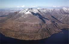 The southern
Cuillin Hills, looking NW.
The southern
Cuillin Hills, looking NW.