|
|
The
Cook-Austral volcanic chain
|
|
|
|
The Cook-Austral volcanic chain is
located on the southern part of the Pacific plate,
in a region of anomalous shallow seafloor known as
the South Pacific superswell
[McNutt & Fischer, 1987]. This region
also corresponds to a broad geochemical anomaly called
SOPITA (South Pacific Isotopic and Thermal Anomaly,
[Staudigel et al., 1991]). The Cook-Austral
chain extends to the northwest for > 2,200 km from
Macdonald Seamount, an active submarine volcano, to
the island of Aitutaki (Figures 1a & b). The chain
comprises 11 islands and two atolls with little area
above sea level (the largest island is 70 km2).
Although oriented roughly in the direction of present
Pacific plate motion (11 cm/yr in a N 115° direction),
the pattern of both the aerial and submarine volcanoes
is rather complex. Two recent geophysical cruises,
one at the southern end of the chain [McNutt et
al., 1997], and the other over the central and
northern parts [Bonneville et al., 2002]
have revealed the complexity of the overlapping volcanism.
|
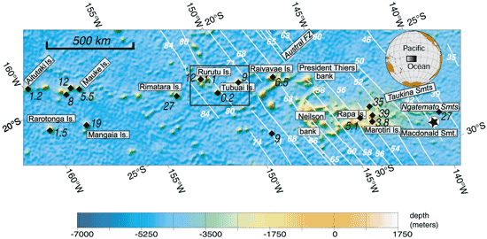
Figure 1a. Shaded view of seafloor topography
for the Cook-Austral region (see upper inset for location).
Map projection is made along direction of present
motion of Pacific plate (from right to left). White
lines correspond to crustal magnetic anomalies, and
their corresponding ages are in white numerals. Black
diamonds represent places where K-Ar or Ar/Ar ages
are known. These ages, in Ma, are printed in black.
Click on image for enlargement.
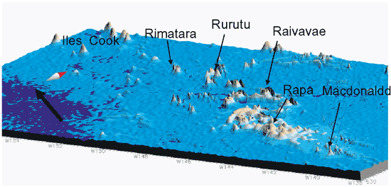
Figure 1b. Three-dimensional view of the Cook-Austral
region. Click on image for enlargement.
|
The morphology and geometry of the island groups
suggest the existence of two distinct volcanic alignments.
The Aitutaki-Mauke Islands group (Rimatara, Rurutu,
Tubuai, Raivavae, and Président Thiers bank)
form the northeast alignment. Rarotonga and Mangaia
Islands, Neilson Bank, Rapa, Marotiri, and Macdonald
Seamount, the only known active volcano, form the
southwest branch.
The age of the oceanic crust along
the chain ranges from ca. 35 Ma to 80 Ma [Mayes
et al., 1990]. Several good K-Ar or Ar/Ar ages
have been measured for almost all the islands, on
seamounts in the Taukina and Ngatemato chains and
in the northern Austral region (Figure 1a). In the
north of the Cook-Austral region, Rarotonga has a
younger age of 1.1 Ma [Duncan & McDougall,
1976]. At Aitutaki, a 1.2 Ma age coexists with a 8.5
Ma stage [Turner & Jarrard, 1982]. In
Rurutu, two different volcanic stages have been identified,
an old one at 12 Ma [Duncan & McDougall,
1976], compatible with the progression in ages along
the northeastern volcanic alignment, and a young one
at 1.1 Ma.
|
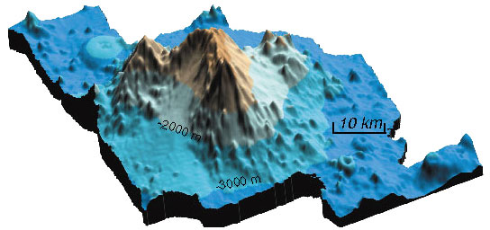
Figure 2. Three-dimensional view
of seafloor in vicinity of Arago Seamount. The location
corresponds to the black box in Figure 1a.
|
| The initial construction
stage of Rurutu can be linked to the magmatic source
that formed Tubuai, as it has the same petrologic and
geochemical characteristics (see below) and the distance
between the two islands is compatible with the absolute
Pacific plate motion at that time. However, the source
of the later 1.1 Ma volcanic event on Rurutu must be
sought on a seamount 130 km southeast of Rurutu [Bonneville
et al., 2002; Figure 2], the Arago Seamount, which
was named after the French Navy ship that discovered
it in 1993. Notably, numerous cones exist between Rurutu
and Arago in this 4,500-m-deep basin, but no clear crustal
swell seems to be associated with this axis. |
Figure 3. Hotspot-track reconstruction for the
three groups of volcanoes identified (see text). Black
numbers indicate time (in Ma) along each track. The
northernmost track starts at 6.5 Ma for the last volcanic
event known on this track. The active Macdonald and
recently active Arago Seamounts are represented by
black stars. Click on image for enlargement.
|
|
It is interesting to reconstruct
the apparent path followed by a hotspot on the seafloor,
moving its present location back in time. We used the
set of stage poles proposed by Wessel & Kroenke
[1997] completed by the pole previously proposed by
[Yan & Kroenke, 1993] for the period 0-3
Ma. If we use a 100-km-wide track as representative
of the zone of influence of a given hotspot source,
we clearly see in Figure 3 that the Macdonald hotspot
could not have generated the northern Austral Islands.
Furthermore, its track fits well with the 19 Ma age
of Mangaia and with the K-Ar age of 9 Ma obtained on
a seamount during the same cruise. On the other hand,
the northern Austral Islands can be explained well by
a hotspot source that probably stopped producing magma
at Raivavae ca. 6.5 Ma. The Arago track fits quite well
with Rurutu’s age and Cook Island ages. The Cook-Austral
archipelago comprises at least 3 volcanic chains from
south to north – the Macdonald track (in yellow
on Figure 3) from Macdonald seamount (0 Ma) to Mangaia
(19 Ma), the Arago track (in pink on Figure 3) from
Arago seamount (0.2 Ma) to Atiu Island (8 Ma) and the
Raivavae track (in light blue on Figure 3) from Raivavae
Island (6.5 Ma) to Rurutu Island and nearby seamounts
(12 Ma). Rarotonga and Aitutaki islands are also located
at the beginning of a new volcanic track but more data
are needed in order to to propose a valid reconstruction
for this northwestern part of the Cook-Austral archipelago.
Note that volcanoes are often not located exactly on
track, which suggests lithospheric control rather than
a change in the location of the source. |
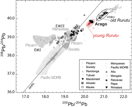
Figure 4. 208Pb/204Pb vs.
206Pb/204Pb isotope diagram
for published data from Austral Islands basalts. NHRL
– Northern Hemisphere reference line; EMI and
EMII – enriched-mantle sources I and II, respectively;
HIMU – high-µ [(U + Th)/Pb] mantle source.
|
The geochemistry
data (Figure 4) are in good agreement with the geodynamical
reconstruction proposed above. Although great heterogeneity
is observed on the scale of the superswell, relative
homogeneity occurs on the scale of each hotspot track.
The Arago track appears to be the most homogeneous and
could be related to the young Rurutu volcanic episode
(1 Ma). Rimatara Island samples, although dated at 27
Ma, clearly belong to the Young Rurutu episode. Rimatara
Island thus probably belongs to this track and the existing
radiometric age, which has already been questioned by
several authors, is likely an error. |
|
Summary
Arago Seamount is the most recent surface
expression of the hotspot responsible for the recent
volcanic activity at Rurutu and probably for other volcanoes
in the Cook Islands chain. The only possible track for
Macdonald hotspot is along a southeastern path and it
could not have supplied the magma for the northern Austral
Islands. For these latter islands an extinct magmatic
source close to the Austral Fracture Zone is required.
With this new scheme added to the already complicated
geological history of this region, two common characteristics
of all the hotspot tracks identified so far may be highlighted:
- a short lifespan (< 20 My);
- several hotspots are active simultaneously on a
region of the seafloor < 2,000 km in diameter.
The future goal is to identify the
mechanism that could cause this apparent rythmicity
of the volcanism in both space and time. These short-lived
and closely spaced hotspots are not consistent with
discrete mantle plumes of deep origin. A preliminary
hypothesis favors more local upwelling in the upper
mantle strongly influenced by weaknesses in the lithosphere. |
- Bonneville, A., R. Le Suavé, L. Audin, V.
Clouard, L. Dosso, P.-Y. Gillot, P. Janney, A. Jordahl
Kelsey, and K. Maamaatuaiahutapu, Arago Seamount :
The missing hot spot found in the Austral Islands,
Geology, 30 (11), 1023-1026,
2002.
- Duncan, R.A., and I. McDougall, Linear volcanism
in French Polynesia, J. Volc. Geotherm. Res.,
1, 197-227, 1976.
- Mayes, C.L., L.A. Lawver, and D.T. Sandwell, Tectonic
history and new isochron chart of the South Pacific,
J. Geophys. Res., 95 (B6),
8543-8567, 1990.
- McNutt, M.K., D.W. Caress, J. Reynolds, K.A. Jordahl,
and R.A. Duncan, Failure of plume theory to explain
midplate volcanism in the Southern Austral islands,
Nature, 389, 479-482, 1997.
- McNutt, M.K., and K.M. Fischer, The south Pacific
Superswell, in Seamounts, Islands and Atolls,
edited by B. Keating, P. Fryer, R. Batiza, and G.
Boethlert, pp. 25-34, AGU, Washington D.C., 1987.
- Staudigel, H., K.-H. Park, M. Pringle, J.L. Rubenstone,
W.H.F. Smith, and A. Zindler, The longevity of the
South Pacific isotopic and thermal anomaly, Earth
Planet. Sci. Lett., 102, 24-44,
1991.
- Turner, D.L., and R.D. Jarrard, K/Ar dating of the
Cook Austral island chain; a test of the hot spot
hypothesis., J. Volc. Geotherm. Res., 12,
187-220, 1982.
- Wessel, P., and L. Kroenke, A geometric technique
for relocating hotspots and refining absolute plate
motions, Nature, 387, 365-369,
1997.
- Yan, C.Y., and L.W. Kroenke, A plate tectonic reconstruction
of the Southwest Pacific, 0-100 Ma, in Proc. Ocean
Drilling Project, Scientific Results, pp. 697-709,
1993.
|
|
|