 |
The offshore East African Rift and the Comoros hotspot |
Dieter
Franke
Federal Institute
for Geosciences and Natural Resources, Hannover, Germany
(BGR); Dieter.Franke@bgr.de
This webpage is a summary of: Franke, Dieter, Wilfried Jokat, Stefan Ladage, Harald Stollhofen, Jennifer Klimke, Ruediger Lutz, Estevão Stefane Mahanjane, Axel Ehrhardt and Bernd Schreckenberger, The offshore East African Rift system: Structural framework at the toe of a juvenile rift, Tectonics, | DOI: 10.1002/2015TC003922.
Introduction
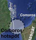
The offshore branch of the East African Rift System (EARS) offers the unique possibility to study in situ rift-hotspot interactions. The Comoros hotspot has been recently proposed to be one of 11 “primary plumes” on Earth (French & Romanowicz, 2015), deeply rooted and with an effective temperature excess of 400–500°C. This hotspot overlaps with the offshore EARS, the youngest portion of the EARS that has developed since the late Miocene (Figure 1).
The offshore EARS
The roughly N-S trending East African Rift system (EARS) extends for thousands of kilometers onshore Africa, comprising two branches (e.g., Chorowicz, 2005; Ebinger, 2012). The structural architecture and evolution of the offshore continuation of the EARS into the Mozambique Channel was studied by Franke et al. (2015) using recently acquired multichannel reflection seismic and bathymetry data in the offshore area between northern Mozambique, Madagascar and the Comoros (Figure 1).
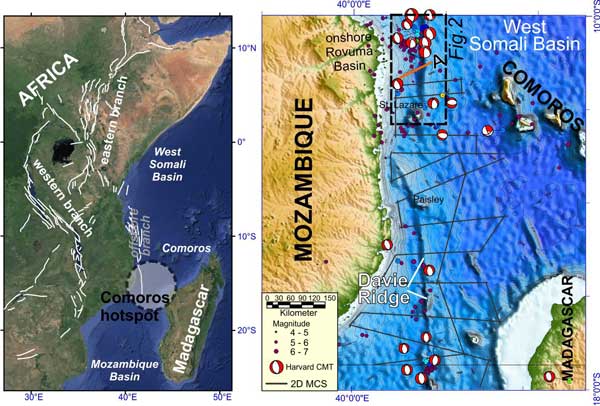
Figure 1: (Left) The main faults of the western and eastern branches of the East African Rift System (from Chorowicz (2005) and Macgregor (2015)). The position of the Comoros hotspot is shown according to French & Romanowicz (2015). (Right) Grey lines indicate the position of geophysical profiles. Earthquake locations and magnitudes (1973-2014; mb > 4.0) are shown as magenta circles according to the National Earthquake Information Center (NEIC) catalog, and earthquake moment tensors from the Global Centroid Moment Tensor catalog (Ekström et al., 2012). The dashed black box shows the position of Figure 2.
Sub-recent to recent offshore extensional deformation, as indicated by seismicity (Figure 1) is confirmed by the reflection seismic data. From north to south a younging in deformation is observed. Whereas scattered normal faults penetrating the sedimentary successions and offsetting the seafloor for only some 10’s of meters are present in the south, a much more mature, symmetric rift graben (the Kerimbas Graben) is developed in the north. The structural data indicate that extension is overall continuous but decreasing in magnitude from North to South (Franke et al., 2015). The offshore branch of the EARS thus resembles the general north-to-south propagation style of deformation that is well known from the onshore segments of the rift, although the timing of deformation is generally younger there compared to the main onshore rift.
The Kerimbas Graben offshore northern Mozambique is an about 150 km long and 30 km wide symmetric rift graben. The graben is bounded by prominent, 10’s of kilometers long, N-S trending border faults and the depression is about 1 km deep on average (Figure 2). Based on a detailed stratigraphic study (Mahanjane & Franke, 2014) and an analysis of fault heaves, Franke et al. (2015) deduce that deformation, resulting in the formation of the Kerimbas Graben, took place predominantly during post-Miocene times.
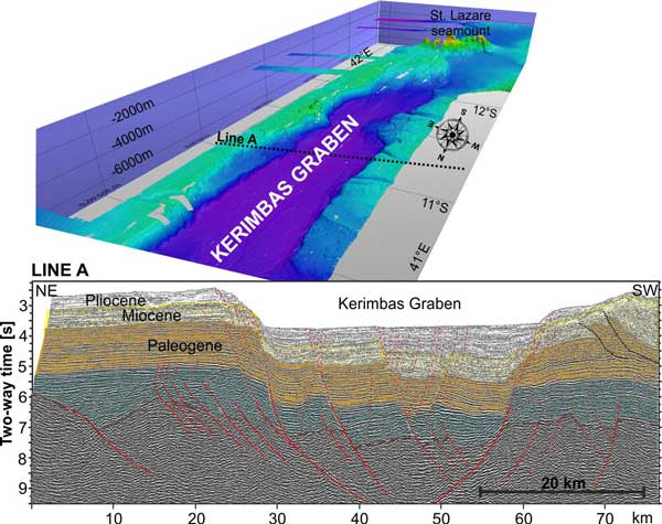
Figure 2: (Top) Seafloor bathymetry of the area offshore northern Mozambique with a clear seafloor expression of the offshore EARS. The symmetric Kerimbas rift graben is ~150 km long and ~30 km wide. The location of reflection seismic line A is indicated. (Bottom) Reflection seismic line across the Kerimbas Graben. Major faults from both earlier extensional deformation, dissecting the basement, and recent deformation, dissecting the seafloor are indicated. Sediment stratigraphy has been mainly adopted from Mahanjane and Franke (2014). Vertical exaggeration is ~2.
An important finding of the study of Franke et al. (2015) is that the entire offshore branch of the EARS lacks significant volcanism. Along the offshore EARS there are only negligible indications of recent volcanism in the reflection seismic data such as sills and dikes. The Davie Ridge between 14°S and 19°S reveals no or only a very weak magnetic signature, excluding the possibility that major portions are made up of basaltic rocks. Two major seamounts (Paisley and St. Lazare) are located along the strike of the Davie Ridge (Figure 1). Dated dredge samples are not available. However, geochemical composition and similarities to the Lebombo magmas in southern Mozambique and Madagascar basalts suggest a Cretaceous age, likely Turonian, for both seamounts (Bassias & Leclaire, 1990). This is well in agreement with onlapping Cenozoic sedimentary successions on the seamount flanks (Mahanjane, 2014), which corroborate a pre-Cenozoic age of the seamounts. Thus, these seamounts are unrelated to the much-younger offshore EARS.
The offshore portion of the EARS, thus, is similar to the onshore western EARS and the amagmatic fault systems of central Tanzania, which are devoid of magmatism (Ebinger, 2012; Le Gall et al., 2004).
Abundant volcanism around the magma-poor rift
Less than 200 km away from the offshore EARS, the Comoros archipelago (Figure 1) formed simultaneously as a northwestward prograding volcano chain, younging in the opposite direction compared to the offshore rift. This chain of volcanic islands and seamounts becomes progressively older from the still-active volcanism at Grande Comoros (Emerick & Duncan, 1982) toward the 10–7 Myr old mafic volcanic rocks in northern Madagascar (Melluso & Morra, 2000). Although there are different interpretations of the origin of the Comoros volcanism, it is commonly regarded as hotspot related (Emerick & Duncan, 1982; King & Adam, 2014).
Discussion and Conclusion
There are at least three observations that are surprising in the context of rift-plume interactions:
- The Kerimbas rift graben is found at a waterdepth of more than 2 km, puzzlingly deep in view of the major uplift expected from plume-related sublithospheric flow;
- The offshore branch of the EARS propagates from north to south i.e. towards the postulated hotspot location. Extension is overall continuous but decreasing in magnitude towards the postulated hotspot. This finding is similar to the situation during the continental breakup that formed the South and North Atlantic oceans. As concluded by Koopmann et al. (2014), rifting initiated in both the South and North Atlantic distal from the proposed locations of hotspots there, Tristan and Iceland respectively. There, rift migration was toward the hotspot positions and there is consistent delay in breakup at the proposed paleo-position of hotspots and the location of abundant onshore volcanism [Ed: See also http://www.mantleplumes.org/RiftHotspotControl.html];
- The offshore EARS evolved magma-poor since its initiation in the late Miocene. It might be speculated that the lithosphere is not yet broken and that the rift will exploit possibly hotter-than-average mantle at a future breakup time. However, this would mean that a 30 km-wide mature rift graben, the Kerimbas Graben evolved over an unbroken lithosphere and consequently extension and rifting was induced by far-field plate boundary forces rather than deep-mantle processes.
Apparently the seismic anomaly interpreted by French & Romanowicz (2015) as a mantle plume at Comoros has very little influence on the progressive extensional deformation along the northern Mozambique continental margin which may lead to continental breakup sometime in the future. Thus, this setting offshore Mozambique provides another case history showing that mantle plumes alone are unlikely to cause continental breakup.
References
-
-
-
Ebinger, C., 2012, Evolution of the Cenozoic East African rift system: Cratons, plumes, and continental breakup, in Bally, D.G., and Roberts, A.W., eds., Regional Geology and Tectonics: Phanerozoic Rift Systems and Sedimentary Basins: Boston, Elsevier, 132-162.
-
Ekström, G., Nettles, M., and Dziewo?ski, A.M., 2012, The global CMT project 2004–2010: Centroid-moment tensors for 13,017 earthquakes: Physics of the Earth and Planetary Interiors, 200–201, 1-9.
-
-
Franke, D., Jokat, W., Ladage, S., Stollhofen, H., Klimke, J., Lutz, R., Mahanjane, E.S., Ehrhardt, A., and Schreckenberger, B., 2015, The offshore East African Rift System: Structural framework at the toe of a juvenile rift: Tectonics, DOI: 10.1002/2015tc003922.
-
-
-
Koopmann, H., Brune, S., Franke, D., and Breuer, S., 2014, Linking rift propagation barriers to excess magmatism at volcanic rifted margins: Geology, 42, 1071-1074.
-
Le Gall, B., Gernigon, L., Rolet, J., Ebinger, C., Gloaguen, R., Nilsen, O., Dypvik, H., Deffontaines, B., and Mruma, A., 2004, Neogene-Holocene rift propagation in central Tanzania: Morphostructural and aeromagnetic evidence from the Kilombero area: Geological Society of America Bulletin, 116, 490-510.
-
-
-
-
last updated 17th
November, 2015 |