 |
Late Miocene fish fossils in Utah support accelerated extension and subsidence, not thermal uplift or a continental divide in the Eastern Snake River Plain |
Gerald R. Smith1 & Patrick H. McClellan2
1Museum of Zoology, University of Michigan, Ann Arbor, MI 48109; grsmith@umich.edu
2Independent, Roseville, California; p.mcclellan@comcast.net
This webpage is a summary of: McClellan, P. H., and G. R. Smith. 2020. Late Miocene fishes of the Cache Valley Member, Salt Lake Formation, Utah and Idaho. Miscellaneous Publications of the Museum of Zoology, No. 208:1-54.
Because fishes live only in water, they can disperse only through aquatic connections. Therefore, dispersal is closely tied to regional hydrographic history. The Miocene and Pliocene rift lakes of the Western Snake River Plain, southwestern Idaho, supported a rich aquatic fauna, a part of which dispersed to Cache Valley in northern Utah in the Late Miocene (McClellan, 1977; Smith et al., 1982; McClellan & Smith, 2020).
Eleven shared species must have crossed the Snake River Plain in the late Miocene. They are low-gradient warmwater fish species and snails. Notably absent are high-elevation, high-gradient trout, mountain whitefish, and sculpins, which inhabited the Western Snake River Plain and inhabit the Continental Divide near Jackson, Wyoming, today. The dispersal route used by fish and mollusks probably occurred between 7.9 Ma and 6.3 Ma through lakes in depressions left by the Twin Falls, Picabo, and Heise volcanic eruptions in the Snake River Plain (Knott et al., 2016, 2020) (Figure 1).
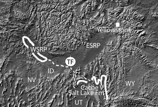
Figure 1: Map of Snake River Plain with locations of Chalk Hills Formation (WSRP), Twin Falls Volcanic Field (TF), and NE part of the lake of the Cache Valley Member of the Salt Lake Formation. Dashed line represents proposed paths of fish emigration from the WSRP to the Cache Valley lake.
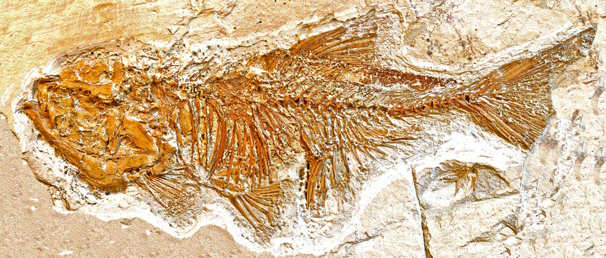
The presence of warmwater Archoplites (maximum native elevation, 600 m), Lavinia (maximum elevation, 1374 m, Figure 2), Mylocheilus (maximum elevation, 1085, Figure 3), Acrocheilus (maximum elevation, 1524 m), and catfish (maximum elevation, 1540 m), and the absence of upland, coolwater salmonids and cottids in the areas connecting their habitat in the lakes of the Western Snake River Plain and the Cache Valley fossil-bearing sediments, contradict the hypothesis of an intervening Continental Divide and the ~3 km high, cool, ecological filter it predicts.
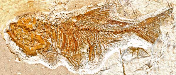
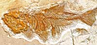
Figure 2: Cache Valley minnow, Lavinia. Click here or on image for enlargement.
Figure 3: Cache Valley minnow, Mylocheilus.
Several western fish genera inhabited both the Eastern and Western Snake River Plain east and west of Twin Falls in the Miocene and Pliocene; none of the 33 extant Wind River or Bighorn Basin fish species from east of the modern divide are known to have ever existed in the Eastern Snake River Plain. The fossil fish distributions are consistent with evidence for Plinian explosive volcanoes in the Central Snake River Plain (Knott et al., 2016, 2020; Ellis, 2013:745). These volcanoes left voluminous tuffs in their craters and in their subsiding centers, up against the elevated margins of the plain. There were long periods (0.5–1 m.y.) of low elevations including lakes (and we infer fishes). Fluid ignimbrite sheets traveled long E-W distances through this region in the late Miocene. Surface waters probably did likewise in drainages across the cratered lowlands, around the flanks of migrating thermal uplifts (if any), and between intermittent lakes that likely occupied calderas and maars along the Eastern Snake River Plain (Ellis et al., 2013; Knott et al., 2016, 2020). Instead, those authors note that down-warping, not uplift, preceded caldera-filling eruptions (Anders, 1994).
We propose that streams and lakes provided lowland passage across the ESRP for fish species found in disjunct late Miocene and Pliocene lakebeds of southwestern Idaho and northeastern Utah between the higher plain margins, as opposed to a Yellowstone-like continental divide as proposed by Pierce & Morgan (1992) and Beranek et al. (2006). Those authors found evidence for time-progressive regional uplifts along the not-quite-sequential rhyolitic calderas culminating at Yellowstone, as would be expected from passage over an upwelling mantle plume.
Foulger et al. (2015) concluded from seismic tomography that there is no throughgoing plume of low-velocity mantle below Yellowstone. Anders (1994), using data from the nearby normal faults, suggested easterly migration of a zone of accelerated extension, which was manifested by subsidence rather than uplift. Lund (2008) described structural, stratigraphic, and isotopic data indicating the Eastern Snake River Plain is underlain by a multiply-reactivated northeast-striking Snake River Transfer Zone. This defines Tertiary rift and extensional domains, including the Eastern Snake River Plain, through which the magmas of the Yellowstone “hotspot” track erupted. The regional extension in the Basin and Range Province produced N-S normal faults and fault-bounded local basins that merged with the Eastern Snake River Plain and created opportunities for differential fault-block subsidence, changes in local base levels, lake spillover events, and lowland drainage capture. Late Miocene (7.9–6.3 Ma) drainage from Cache Valley downstream and northwest through Oakley Valley and the Trapper Creek area to the Western Snake River Plain could have provided upstream dispersal access between the Chalk Hills and Cache Valley lakes, but not if the continental divide were at Twin Falls.
References
-
Anders, M. H., 1994. Constraints on North American plate velocity from the Yellowstone hotspot deformational field: Nature, 369, p. 53-55.
-
Beranek, L. P., P.K. Link, and C. M. Fanning. 2006. Miocene to Holocene landscape evolution of the western Snake River Plain region, Idaho: Using the SHRIMP detrital zircon provenance record to track eastward migration of the Yellowstone hotspot. Geological Society of America Bulletin 118:1027–1050.
-
Ellis, B. S., J. A. Wolff, S. Boroughs, D. F. Mark, W. A. Starkel, and B. Bonnichsen. 2013. Rhyolitic volcanism of the central Snake River Plain: A review Bulletin of Volcanology, 75:745–764.
-
Foulger, G. R., R. L. Christiansen, and D. L. Anderson. 2015. The Yellowstone “hot spot” track results from migrating basin-range extension, pp. 215–238. In G. R. Foulger, M. Lustrino, and S. D. King, eds., The Interdisciplinary Earth: A Volume in Honor of Don L. Anderson. Geological Society of America, Special Paper 514 and American Geophysical Union Special Publication 71 https://doi.org/10.1130/2015.2514(14)
-
Knott, T. R., M. J. Branney, M. K. Reichow, D. R. Finn, R. S. Coe, M. Storey, D. Barfod, M. McCurry. 2016. Mid-Miocene record of large-scale Snake River–type explosive volcanism and associated subsidence on the Yellowstone hotspot track: The Cassia Formation of Idaho, USA. Geological Society of America Bulletin, 128:1121–1146.
-
Knott, T. R., M. J. Branney, M. K. Reichow, D. R. Finn, S. Tapster and R. S. Coe. 2020. Discovery of two new supereruptions from the Yellowstone hotspot track (USA): Is the Yellowstone hotspot waning? Geology, 48, https://doi.org/10.1130/G47384.1
-
Lund, K., 2008. Geometry of the Neoproterozoic and Paleozoic rift margin of western Laurentia: Implications for mineral deposit settings, Geosphere 4: 429-444. https://doi.org/10.1130/GES00121.1
-
McClellan, P. H. 1977. Paleontology and paleoecology of Neogene freshwater fishes from the Salt Lake beds, northern Utah. Master’s thesis, University of California, Berkeley, 243 pp.
-
-
Pierce, K. L., and L. A. Morgan. 1992. The track of the Yellowstone hot spot: Volcanism, faulting, and uplift. In Link, P.K., Kuntz, M.A., and Platt, L.B., eds., Regional Geology of Eastern Idaho and Western Wyoming: Geological Society of America Memoir, 179:1–53.
-
Rodgers, D.W., H.T. Ore, R.T. Bobo, Nadine McQuarrie, and Nick Zentner, 2002, Extension and subsidence of the eastern Snake River Plain, Idaho, in Bill Bonnichsen, C.M. White, and Michael McCurry, eds., Tectonic and Magmatic Evolution of the Snake River Plain Volcanic Province: Idaho Geological Survey, Bulletin 30:121-155.
-
Smith, G. R., K. Swirydczuk, P. G. Kimmel, and B. H. Wilkinson. 1982. Fish biostratigraphy of late Miocene to Pleistocene sediments of the western Snake River Plain, Idaho. In B. Bonnichsen and R. M. Breckenridge, eds., Cenozoic Geology of Idaho. Idaho Bureau of Mines and Geology, Bulletin 26:519-542.
Author bios
- Gerald Smith is a retired Professor of Earth and Environmental Science and Ecology and Evolutionary Biology, as well as Curator, Museum of Paleontology and Museum of Zoology.
- Patrick McClellan is a geologist and paleontologist formerly with the US Geological Survey and in academia and private practice, with emphasis on fossil vertebrates, neotectonics, and natural hazard mitigation.
last updated 17th April, 2021 |