 |
 |
Truncated-icosahedral
breakup of Laurasia and Gondwana and anorogenic
magmatism |
|
| James
W. Sears, Gregory
M. St. George &
J. Chris Winne
University
of Montana, Missoula MT 59812
jwsears@selway.umt.edu
|
Abstract
The
large-scale rift systems that broke apart the
Laurasian and Gondwanan supercontinents conform
to the precise dimensions of a truncated-icosahedral
tessellation of the Earth's surface, with triple
junctions separated by 23° along great-circle
arcs, and rift segments intersecting at 120°
and 108°. The rift tessellations provide
a minimum edge-length and therefore a least-work
configuration for the fracturing of a spherical
shell. Anorogenic magmatic provinces, including
flood basalts, anorthosite, and granite-rhyolite
and some hotspots evolved along the rift edges,
especially at triple junctions. The brittle
fracture pattern favors a top-down tectonic
origin for some large igneous outbreaks.
Introduction
Laurasia and Gondwana
broke along the geometrically regular patterns
of a truncated icosahedron, an energy-minimizing
configuration. The icosahedron, one of the five
platonic solids, has 20 similar equilateral-triangle
faces that meet in groups of five at each of
12 vertices (Figure 1). Truncation of the icosahedron
reduces each vertex to a pentagonal facet and
each triangular face to a regular hexagon. All
edge-lengths of the truncated icosahedron are
equal. Each vertex of the truncated icosahedron
touches an encapsulating sphere. Projection
of the truncated icosahedron onto the surface
of this sphere traces the familiar soccer-ball
pattern in which each seam forms a 23.28°
great-circle arc, and each triple junction joins
two hexagons and one pentagon. The tessellation
of polygons is mathematically precise and intolerant,
fixed by projection of a single pentagon. The
truncated icosahedron provides a least-work
rift configuration because it embraces the largest
hexagonal plates permissible on a spherical
tessellation and thereby minimizes the total
length of fractures needed to tessellate a spherical
shell. It would accommodate uniform layer-parallel
extension of the strongest breakable lithosphere;
it thus establishes the upper limit for a fracture
system on a globe.
 |
For both
Laurasia and Gondwana, truncated icosahedral
rifting coincided with drift stagnation,
and may have been driven by lithospheric
extension above an insulated and thermally-expanded
mantle (Ed: see also McHone
et al., 2005). Decompression melting
of asthenosphere beneath opening fractures
along the precise lines of the truncated
icosahedral tessellation may have augmented
anorogenic magmatism. The tessellation
self-organizes within the brittle lithosphere,
and so favors a top-down origin for these
continental rift systems and associated
anorogenic magmatic provinces (see Anderson,
2001, 2002).
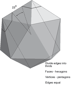
Figure
1: The icosahedron. Truncation produces
a semi-regular space figure with 20 hexagonal
and 12 pentagonal faces. Each edge has
central angle of 23.28°.
Projection of the figure onto a sphere
yields the familiar soccer-ball pattern
of alternating hexagons and pentagons.
Laurentian and Gondwanan rift systems
precisely match this tessellation, which
minimizes the length and energy needed
to propagate fractures to relieve layer-parallel
tension in a stagnant spherical shell. |
Laurasia
The break-out of Laurentia from Laurasia
followed rift zones that match a truncated-icosahedral
hexagon and part of a neighboring pentagon (Figure
2). In order for a rift system to achieve this
congruence, each rift zone must follow a great
circle having an arc-length of 23° (2600
km on the Earth's surface) and must intersect
neighboring rifts at 120° for hexagons,
or 108° for pentagons. The Greenland, Arctic,
western Canadian, and Montana-Tennessee sides
of the Laurentian hexagon indeed have arc-lengths
of 23° and turn at 120°, closely congruent
with a truncated-icosahedral hexagon. The Alabama,
Montana, Yukon, Greenland, and Scottish promontories
of Laurentia are closely congruent with five
vertices of the hexagon. Figure 2 suggests that
the late Mesoproterozoic Grenville continental
collision collapsed the sixth hexagonal vertex.
Broad zones of Proterozoic anorogenic magmatism
follow these edges. The anorogenic suites are
characteristically bimodal, A-type magmatic
rocks having within-plate trace-element signatures
(Van Schmus & Bickford, 1993). The
rifts evolved into early Paleozoic passive margins.
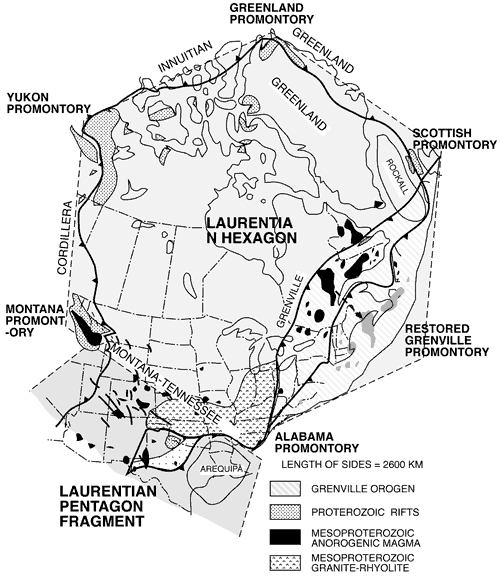
Figure 2: Truncated-icosahedral-fracture
tessellation of Laurentia, after Sears (2001).
Each side of a hexagon subtends ~ 23° of
arc. Mesoproterozoic and Neoproterozoic anorogenic
provinces occur along edges. Restored for Cenozoic
continental drift. This map is a central projection
onto two faces of a truncated icosahedron.
Gondwana
Figure
3 restores Gondwana into its 200-Ma configuration
and illustrates the close congruence of Gondwanan
rift zones and anorogenic magmatic provinces
to 15 edges of a singular tessellation. The
truncated-icosahedral tessellation is rigorous;
Antarctica defines a pentagon, the other polygons
are dependent. More than 20,000 km of rifts
followed tessellation edges during breakup of
the supercontinent.
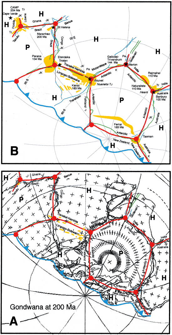
Figure
3: A. Gondwana configuration at 200 Ma, after
Lawver et al. (2002), showing congruence of
Gondwanan rifts with truncated icosahedral tessellation.
Circles at truncated-icosahedral vertices (triple
junctions) are separated by ~ 23° of arc.
B. Simplified map of Gondwana on the same base
as A, except Earth coordinates rotated slightly
from Lawver to demonstrate the congruence of
active hotspots associated with Gondwanan large
igneous provinces and tessellation triple-junctions.
Stars: Active hotspots, names italicised. Yellow:
Large igneous provinces and dikes. Blue: Gondwanan
rifts. Red: Ideal truncated-icosahedral tessellation.
P, Pentagon; H, Hexagon. Ages of rifts from
Sengor & Natalin (2001): Pe, Permian; Tr,
Triassic; J, Jurassic, K, Cretaceous. Click
here for enlarged
figure .
Large
anorogenic igneous provinces broke out near
vertices of the Gondwanan tessellation. Several
volcanic hotspots are thought to represent continuing
anorogenic magmatism at the original sites of
the initial outbreaks. The following hotspot-igneous
province links are possible: Cape Verde (or
Fernando?) hotspot – CAMP,
St Helena hotspot – Maranhão, Tristan
hotspot – Parana-Etendeka, Bouvet hotspot
– Karoo, Marion hotspot Gallodai-Trivandrum,
and Heard hotspot – Naturaliste. With
the exception of Cape Verde (or Fernando?),
these hotspots conform rather closely to the
vertices of a single truncated-icosahedral tessellation.
As shown in Figure 3, the hotspot and rift tessellations
are approximately congruent when Gondwana is
restored onto the hotspot framework.
The fracture
tessellation apparently propagated across Gondwana
before Late Jurassic sea-floor spreading began
to separate its parts. Fracture propagation
may have begun in the Permian or Triassic. The
fractures relieved tensile strain within the
lithosphere, but may not have erupted magma
until the resulting tiles separated sufficiently
to drive decompression melting. Organization
of the fractures may have been a passive, within-Gondwana
response to tension, but separation of the tiles
and magmatic outbreaks may have depended on
global plate-dynamics.
If the
hotspots were indeed generated top-down, drifting
of Gondwana during propagation of the fractures
should have left behind a distorted framework
of asthenospheric hotspots. Initial opening
of the Central Atlantic may have moved Gondwana
and its fracture tessellation off the outbreak
point of CAMP, displacing
the younger parts of the hotspot tessellation
with respect to the Cape Verde (or Fernando)
hotspot. The overall congruence of the hotspots
to the tessellation implies, however, that Gondwana
was largely stagnant during Late Jurassic-Early
Cretaceous magmatic outbreaks, consistent with
a loop in the Gondwanan apparent polar wander
path (DeWitt et al., 1988).
Because
sea-floor spreading and truncated icosahedral
symmetries conflict, Gondwanan plate boundaries
evolved new ridge-transform configurations as
the continental fragments dispersed. The incongruent
southeast coast of Africa is one such transform
boundary.
References
-
-
-
De
Wit, M., Jeffery, M., Bergh, H., Nicolaysen,
L., 1988. Geological map of sectors of Gondwana
reconstructed to their disposition ~150 Ma.
America Association of Petroleum Geologists,
Tulsa, OK 74101, scale 1:10,000,000.
-
Lawver,
L.A., Gahagan, L.M., Dalziel, I.W.D., 1999.
A tight fit – Early Mesozoic Gondwana,
a plate reconstruction perspective. Mem.
Natl. Inst. Polar Res. Spec. Issue 53,
214-229.
-
Sears,
J.W., 2001. Icosahedral fracture tessellation
of early Mesoproterozoic Laurentia. Geology
29, 327- 330.
-
-
Sengör, A.M.C., Natal'in, B.A., 2001. Rifts of the world. In Ernst,
R.E., Buchan, K.L., (Eds.), Mantle plumes:
Their identification through time. Geological Society of America Special Paper 352, 389-482.
-
Van
Schmus, W.R., Bickford, M.E., 1993. Transcontinental
Proterozoic provinces. In Reed, J.C., et al.,
(Eds.), Precambrian: Continental U.S. Geology
of North America C-2, Geological Society
of America, Boulder, Colorado, pp. 171-334.
|
last updated
19th November, 2021 |
|
|
|
