|
Giacomo Corti1, Daniele Maestrelli1, Federico Sani2
1Consiglio Nazionale delle Ricerche, Istituto di Geoscienze e Georisorse, Via G. La Pira, 4, Firenze, Italy; giacomo.corti@igg.cnr.it ; daniele.maestrelli@gmail.com
2Dipartimento di Scienze della Terra, Università di Firenze, Via G. La Pira, 4, Firenze, Italy; federico.sani@unifi.it
This webpage is a summary of: Corti, G., Maestrelli, D. and Sani, F., 2022. Large-to Local-Scale Control of Pre-Existing Structures on Continental Rifting: Examples From the Main Ethiopian Rift, East Africa. Frontiers in Earth Science, 10.
The Main Ethiopian Rift (MER) in the East African Rift System (EARS) offers the possibility to analyse the control of pre-existing structures on rifting on different scales. Ethiopia has been affected by several tectonic events prior to Cenozoic rifting from complex Precambrian phases of collision to extension in the Mesozoic. This long tectonic history created pre-existing structures that controlled the development of the Ethiopian sector of the EARS from a regional to a local scale.
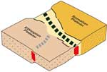
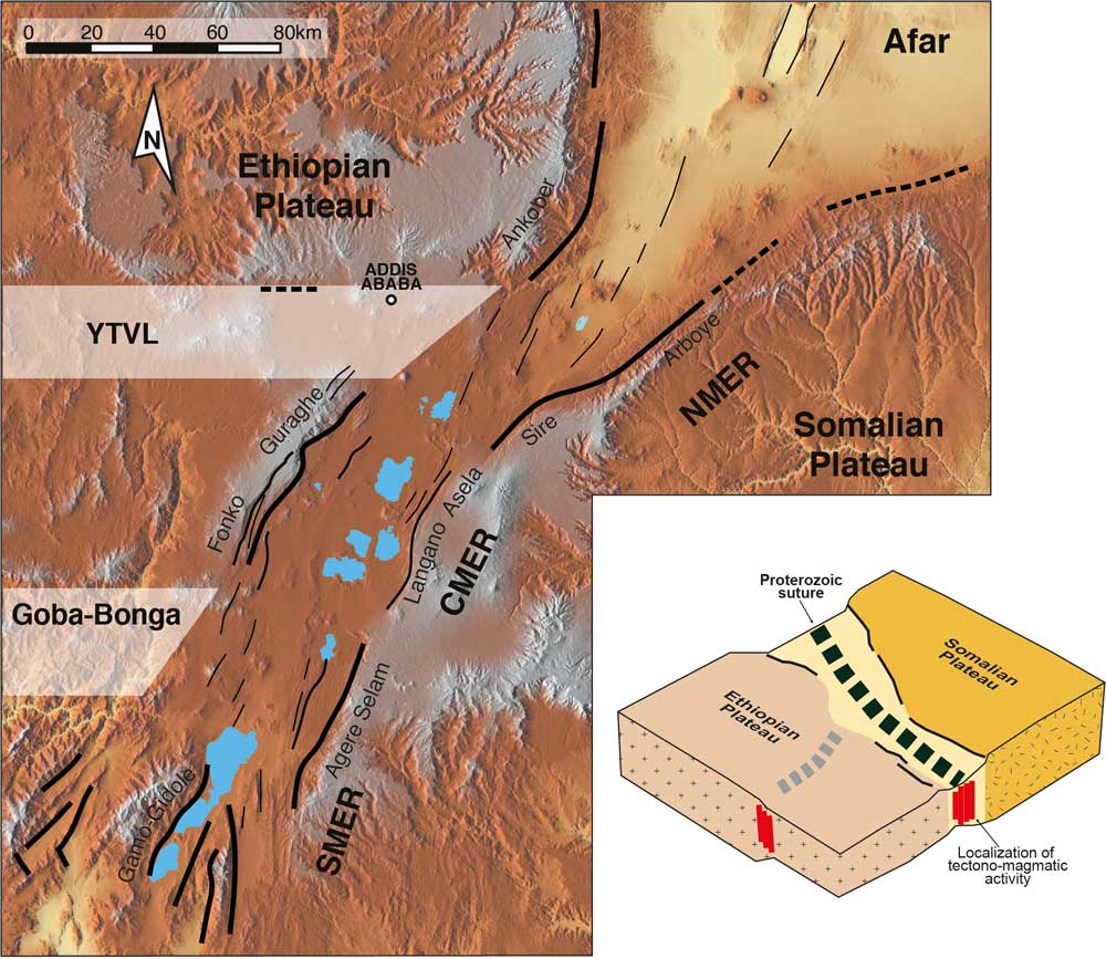
We present an overview of this influence, showing that on a large scale (up to ~ 800-1000 km) rift localization was controlled by lithospheric-scale inherited heterogeneity. This corresponds to a Precambrian suture zone which separates two different lithospheric domains beneath the Ethiopian and Somalian plateaus surrounding the rift (Figure 1). The curved plan-view geometry of this inherited weakness resulted in along-axis variation in the kinematics of rifting, from orthogonal in the southern MER to moderately oblique in the northern MER.

Figure 1: Tectonic setting of the Main Ethiopian Rift, with subdivisions into the different segments: the Northern MER (NMER), Central MER (CMER) and Southern MER (SMER). Black lines schematically indicate the main faults of the rift, with names of the main rift escarpments. Whitish bands indicate the transverse lineaments Yerer-Tullu Wellel (YTVL) and Goba-Bonga. Inset at bottom right shows pre-rift lithospheric domains and location of Cenozoic volcano-tectonic activity in the MER. Cenozoic extension follows rheological boundaries between two distinct Proterozoic basement terranes underlying the Ethiopian and Somalian plateaus. This lithospheric weakness zone corresponds to an ancient suture zone. Click here or on image for enlargement.
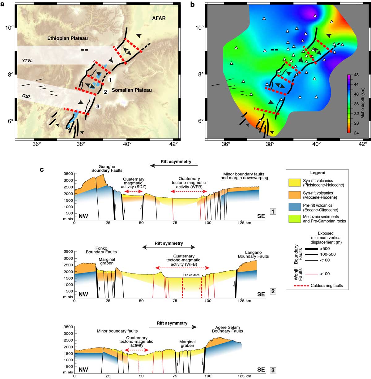
The inherited rheological differences between the two domains largely controlled the along-axis segmentation of the MER. Specifically, the contrast between a strong, homogeneous lithosphere beneath the Somalian plateau and a weaker and more heterogeneous lithosphere beneath the Ethiopian plateau, containing pre-existing lithospheric-scale transverse structures, gave rise to along-axis ~80-100-km-long, alternatively symmetric and asymmetric, rift segments (Figure 2).

Figure 2: Along-axis variations in the structure of the Main Ethiopian Rift (modified from Corti et al., 2018a). a) Interpreted variations in rift symmetry and polarity: single arrows indicate the polarity of the different rift sectors; double arrows indicate symmetry of rifting. Whitish bands indicate the hypothesised plan-view extent of the transverse structures: the Yerer-Tullu Wellel (YTVL) and Goba-Bonga (GBL) volcano-tectonic lineaments. b) Map of depth of the Moho in the MER, modified after Keranen et al. (2009). c) Simplified geological profiles across different sectors of the MER, with vertical exaggeration x10. WFB: Wonji Fault Belt; SDZ: Silti Debre Zeit volcanic belt. Click here or on image for enlargement.
Inherited transverse structures also controlled the development of off-axis volcano-tectonic activity, giving rise to extension-parallel faults and alignments of volcanoes in the plateaus surrounding the rift. Transverse heterogeneities also had a major influence on the interaction and linkage of major rift segments, as seen in the Turkana depression where the Ethiopian and Kenyan rifts interact within an anomalously wide region of deformation and volcanic activity (Figure 3).
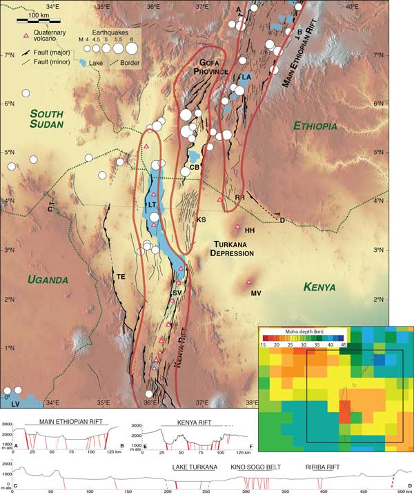
Figure 3: Tectonic setting of the Turkana depression and surrounding regions, with Quaternary faults, seismicity and Quaternary volcanoes superimposed on an SRTM (Nasa Shuttle Radar Topography Mission, 30 m resolution) digital elevation model. CB: Chew Bahir basin; HH: Hurri Hills; KS: Kino Sogo belt; LA: Lake Abaya; LT: Lake Turkana; LV: Lake Victoria; MV: Marsabit volcano; RR: Ririba Rift; SV: Suguta Valley; TE: Turkwell Escarpment. Areas encircled by red lines are the main deformation domains. Inset bottom right shows crustal thickness in the region. Also illustrated are simplified cross sections highlighting the different architecture and distribution of deformation in the Turkana depression compared with the Kenyan and Ethiopian rifts.
On a local scale (<80 km), inherited fabric controlled the geometry of normal faults and the distribution and characteristics of rift-related volcanism. The en echelon arrangement of boundary faults results from the oblique orientation of the pre-existing suture localizing the rift. The faults document a local reorientation of the stress field at the margins of the inherited weakness. Atypical fault characteristics (e.g., angular patterns, S- or Z-shaped plan-view geometries, anomalously low displacement/length ratio) also document reactivation of pre-existing structures (Figure 4).
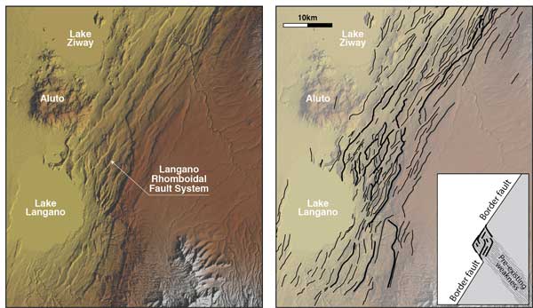
Figure 4: Digital elevation model (NASA-Shuttle Radar Topography Mission, SRTM 30 m resolution; left panel), and faults superimposed onto an SRTM digital elevation model (right panel) of the Langano Rhomboidal Fault System. Inset bottom right: schematic representation of the possible influence of a NW-SE-trending inherited weakness on the fault pattern.
Similarly, inherited structures have been shown to represent zones of crustal weakness that magma can exploit during its ascent, controlling the alignment of volcanic vents, the elongation of some large calderas, and the occurrence of voluminous volcanism in the plateaus surrounding the rift (so-called off-axis volcanism; Figure 5).
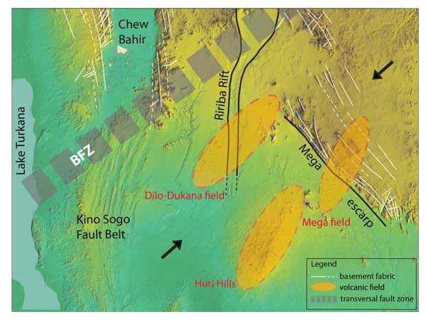
Figure 5: Schematic relationships between the distribution of the Quaternary volcanic fields of Dilo, Mega and Huri Hills (orange ellipses) and major inherited structures (dashed lines in the figure) such as the BFZ (Buluk Fault Zone). Black arrows schematically indicate the main compressive stress resulting from buoyancy forces in the area related to variations in crustal thickness and topography.
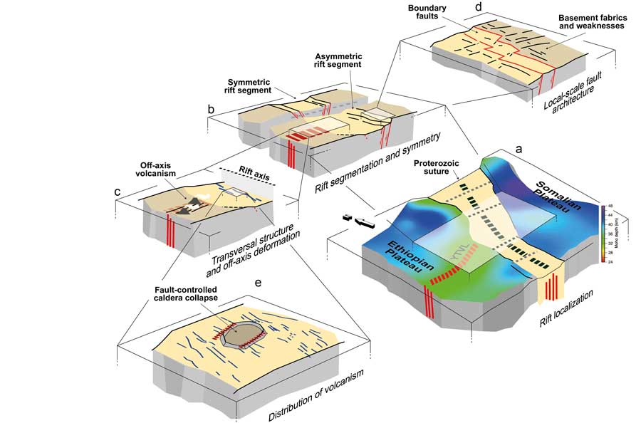
Overall, these observations document the strong control exerted by pre-existing structures on continental rifting on all scales (Figure 6).
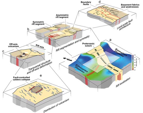
Figure 6: Schematic illustration of the control exerted by inherited heterogeneities on different scales in the MER. From regional- to local scale, we observe: (a) Rift localization controlled by Proterozoic suture. YTVL: Yerer-Tullu Wellel transverse structure; (b) Rift segmentation and asymmetry induced by large-scale transverse structures; (c) Off-axis volcanism controlled by large-scale transverse structures; (d) Local-scale architecture controlled by inherited basement fabrics; (e) Distribution and setting of volcanism controlled by local scale-inherited structures. Click here or on image for enlargement.
References
last updated 14th July, 2022 |