Geological movie explaining metamorphic rocks
What are metamorphic rocks and what do they have to do with plate tectonics?? There's cooking involved??!
Metamorphic rocks are the third kind of rock, along with sedimentary and igneous. This 13.5 minute video by Univ. Texas at Dallas grad student Siloa Willis explains what kinds of Earth kitchens there are and explains how the much younger theory of plate tectonics helps us understand the older discipline of metamorphic petrology.
Check it out at https://www.youtube.com/watch?v=dxTFkfzPX-s
Download useful geochemical spreadsheets and templates
www.geoplotters.com provides useful spreadsheets & templates for geoscientists.
As a scientific community, we can work together to expand & improve the material available.
Please email useful files using the website contact form. Let us co-operate to free up more time for research by streamlining finding files & creating diagrams!
|
|
Museo Universitario di Scienze della Terra
Earth Sciences University Museum, Univ. Rome
EGU blog
…the blog of the Seismology (SM) Division of the European Geosciences Union (EGU).
This blog serves as a platform for the seismology community to share news, events, and activities, as well as updates on the latest research.
It is especially dedicated to the EGU young seismologists.
The blog is run by Matthew Agius.
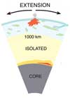
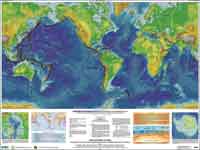
Mantle Plume Processes
Vhub.org is
a site for collaborative volcano research and risk
mitigation.
Use the menus to browse available simulation
tools, data resources and links to all things volcanic.
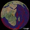
Geological
Society of Africa (GSAf) — Société Géologique
d’Afrique
The Geological Society of Africa (GSAf) was established
in 1973 to encourage geoscientific collaboration and
cooperation across the continent. Its main objectives
are:
- to promote understanding of the earth sciences
and improve standards of earth science education
and research in Africa;
- to provide a forum for discussion and dissemination
of information across national boundaries between
scientists, associations and institutions engaged
in African geology and earth resources;
- to promote the development and
sustainable management of the continent's earth resources,
to advance its socio-economic development; and
- to improve
natural hazards assessment and disaster mitigation.
Mi tierra
se mueve: Plumas del manto
|