 |
The Caribbean
Ocean plateau
|
Keith H. James
Institute of Geography
and Earth Sciences, University of Wales, Aberystwyth,
Wales, UK
khj@aber.ac.uk
 Click here to
download a PDF version of this webpage Click here to
download a PDF version of this webpage
Introduction
This webpage
presents a brief summary of the Caribbean plateau in
the context of the regional geology of middle America
(Figure 1; for a more comprehensive description and
discussion, see also James,
2007). Papers on the plateau tend to concern themselves
with its geochemistry (e.g.,
Kerr et al.,
2003) or seismic structure (Diebold & Driscoll,
1999). There
is rarely comprehensive discussion of its regional
geological context. At best, discussions are
tied to the paradigm that derives the Caribbean plate
from the Pacific (e.g., Pindell & Barrett,
1990, Pindell et al., 1998). This paradigm
invokes plate migration of thousands of kilometres,
major rotation (up to 80°)
of the large continental blocks of Maya and Chortis,
reversal of ocean arc subduction, major rotation of
arc segments (90°), slab roll-back
in a variety of directions, burial of continental fragments
to 80 km depth followed by exhumation during strike-slip,
a plate boundary jump from Cuba to the Cayman Trench
and inter- or back-arc spreading between the
Aves Ridge and the Lesser Antilles.
This model is extremely
complex. Many of its processes lack supporting
data and many existing data are ignored or used selectively. It
continues to become increasingly complex and its proponents
tend to fail to address arguments against it (Pindell
et al.,
2006). The alternative theory,
that the Caribbean plate formed in place between separating
North and South America, is supported by a minority
of workers only, despite the fact that it accounts
for all regional data in the context of simple geological
evolution (e.g., James, 2005, 2006).
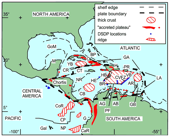
Figure 1. Middle America, AB – Aruba-Blanquilla,
AR - Aves Ridge, BR - Beata Ridge, C – Cuba,
CB – Colombia Basin, CP – Cocos plate,
CR – Cayman Ridge, CT – Cayman Trough,
G – Gorgona Island, GA – Greater Antilles,
Gal – Galapagos Islands, GB – Grenada Basin,
GoM – Gulf of Mexico, HE – Hess Escarpment,
LA – Lesser Antilles, M – Maya, NP – Nazca
plate, NR – Nicaragua Rise, VB – Venezuela
Basin, YB – Yucatán Basin. Locations
of Mesozoic plateau rocks in red (after Donnelly et
al., 1990). The "original" Caribbean
plateau (rhomoboid area) lies in the western Venezuela
Basin, centred on the Beata Ridge and bounded to the
SE by the Central Venezuelan FZ (blue). Accreted elements
distributed around the area are commonly attributed
to the plateau, though many clearly lie on different
plates. Thick crust also occurs in the Yucatán
and Grenada basins.
Caribbean geology, distributed over
many different countries and islands, appears to be
complex. Documentation ranges from good, in highly
explored, contiguous areas in northern South America,
to poor or absent in remote areas of tropical vegetation
cover and weathering. There
are no recognised oceanic spreading anomalies or fractures
to indicate the age or tectonic origin of Caribbean
plate crust. The only spreading ridge in the
whole of Middle America lies in the centre of the Cayman
Trough, which is a large, plate-boundary pull-apart.
Geophysical
investigations show that parts of the Caribbean plate
are much thicker than normal oceanic crust and have
a different seismic velocity structure (Officer
et al., 1957). This thick crust is described
as an oceanic plateau (Donnelly, 1973). The "original" plateau
(rhomboid area in Figure 1) was a 20-km-thick area
in the western part of the Venezuela Basin. Over
time this has become linked to similar crust in the
Colombia Basin and oceanic crust accreted around the
plate margins. The assemblage is regarded as
the best exposed oceanic plateau in the world (Kerr
et al., 1997).
The prevailing Pacific/plume model
The
prevailing model holds that Caribbean crust formed
in the Pacific (e.g.,
Pindell & Barrett,
1990). and thickened into a plateau over a hotspot
or mantle plume (e.g.,
Kerr et al., 2003). In this model, the
plate migrated eastward between the Americas. On
its way it collided with and choked a west-facing inter-oceanic
subduction arc, causing metamorphism, reversal of subduction
direction and a change in arc chemistry from primitive
to calc-alkaline. The arc was then pushed in
front of the plateau into the area between
the Americas. Its
northern and southern parts rotated and accreted along
the Greater Antilles and northern South America, where
volcanism ceased. The Lesser Antilles are the
active remnants of the arc, marking subduction of Atlantic
oceanic crust from the east. The continental Caribbean
component, Chortis in the north west, was accreted
after the plate entered between the Americas.
Two regional
seismic reflections, A" and B",
are seen across the Caribbean. DSDP/ODP drilling showed
that A" marks the top of a middle-Eocene chert-limestone
section below unconsolidated sediments. Horizon
B" is smooth over the plateau and rough to the
southeast. Smooth B" ties to 90 – 88
Ma basalts sampled by drilling (Saunders
et al.,
1973) and these are interpreted to indicate voluminous
plateau volcanism over a short period. Rough
B" has
never been penetrated. It has anormal oceanic
crustal signature but its thickness of only around
3.5 km indicates extension (Diebold & Driscoll,
1999).
The "original" plateau has
abrupt, linear NW and SE margins, both trending NE. The
NW margin of the Beata Ridge drops down to the normal
oceanic crust of the Haiti Basin by as much as 3,500
m. The
SE margin – the Central Venezuelan Fault Zone
(Biju-Duval et al., 1978) is marked by a
change in B" character from smooth to rough (Talwani
et al., 1977) .
Seismic data reveal the internal structure
of the plateau. NE
trending highs are flanked by at least two levels of
dipping reflections. The architecture has been interpreted
as large wedges of flows or sills sourced by highs
which are built of vertical dykes (Diebold & Driscoll,
1999). The southeastern boundary of the plateau – the
Central Venezuelan Fault Zone - is a major fault that
bounds one of these wedges. The Moho drops abruptly
across this fault. Diapiric features penetrating
the sea floor above the plateau are interpreted to
be volcanoes (Diebold & Driscoll, 1999).
The alternative
model
There are only six DSDP/ODP sample
sites on the Caribbean plateau and they penetrate only
the top of a 20-km-thick section. Two
other sites are located on the Hess Escarpment and
in the Colombia Basin. Accreted
plate margin rocks suggest that oceanic basalts formed
also at around 120 Ma and that magmatism was continuous
from the Albian to the Cenomanian or Campanian (e.g.
Beets et al., 1977; Maurasse
et al., 1979). The
magmatism that thickened the plateau above the continental
fragments was thus not a single extrusive
event of short duration.
Great similarity in form and tectonic
location between the Caribbean, and the Scotia and
Banda plates indicates common origins (James,
2006). The
latter two plates have calibrated magnetic anomalies
and they are known to have formed in place by back-arc
spreading. Scotia
and Banda spreading changed location and orientation
with time. Both plates are rimmed by distributed
continental fragments. Banda is also known to
carry "internal" continental fragments (Milsom,
2007) and Scotia may do so also (Barker, 2001).
Crustal
thicknesses of 30 or more kilometres (seismic, gravity)
and continental densities (gravity), quartz sands,
ancient zircons and continental chemical signal in
Cretaceous arc rocks and abundant silica-rich ignimbrites,
andesites and tonalites argue for the presence of continental
fragments around the Caribbean as well (James,
2007a, b). They lie beneath the Nicaragua Rise,
throughout Central America and below the Greater Antilles/northern
Lesser Antilles, hidden below obducted oceanic/arc
rocks and Cenozoic limestones and volcanic rocks.
The NE
tectonic grain of the Caribbean plateau is attributed
to underlying basement highs, which give rise to
magnetic lineations over the area (e.g.,
Diebold & Driscoll,
1999). However, the origin of the trend is rarely
discussed in papers. The plateau shares its structural
grain with its continental neighbours, North and South
America, the Chortis and Maya blocks, the Yucatán
and (northern) Grenada basins and the distal parts
of the Cayman Trench (James,
2006). Onshore
geology shows that the regional NE tectonic grain is
inherited from Proterozoic – Palaeozoic trends,
reactivated by Triassic-Jurassic rifting during Pangean
break up (Figure 2). In
the whole of middle America there is no trace of the
radial pattern expected above a plume.
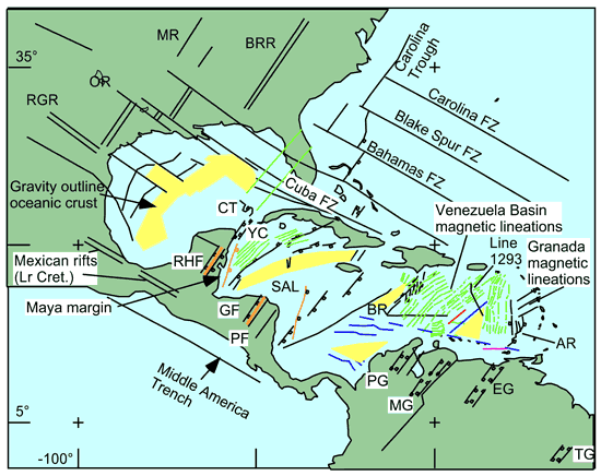
Figure 2. Middle America is bracketed
by N60°W
fractures (Cuba Fz., Middle America Trench) and shows
in internal regional tectonic pattern of N35°E
and N60°W faults. They reflect Triassic-Jurassic
rifting and Jurassic-Cretaceous drifting. The Caribbean
plate shares this regional pattern and shows no radial
signature as expected of a plume. The red line
marks the mapped SE limit of Caribbean plateau–the
Central Venezuela FZ. Green lines are published
magnetic anomalies. Blue lines are additional
lineaments noted here. The NE trend
over the "plateau" area reflects basement
structures. Anomalies in the Yucatán Basin
might have the same origin Magnetic anomalies
in the east, parallel to the Aves Ridge, suggest that
it was a back arc spreading centre, analogous to the
East Scotia Ridge. BR - Beata Ridge, BRR - Blue
Ridge Rift, CT - Catoche Tongue, EG - Espino Graben,
GF - Guayape F., MG - Mérida Graben, MiG - Mississippi
Graben, OR - Oachita Rift, PF- Patuca F., PG - Perijá Graben,
RGR - Río Grande Rift, RHF - Río Hondo
F., SAL - San Andrés Lineament, TF - Ticul F.,
TG - Takutu Graben, TT - Texas Transform, YC- Yucatán
Channel.
The tectonic trend links the Yucatán Peninsula
to Florida, across the SE Gulf of Mexico (Gough, 1967).
Here, DSDP drilling and seismic data show Triassic/older
basement blocks flanked by wedges of Jurassic sediments,
evaporites and igneous flows/sills, overlain by Cretaceous
carbonates, a regional middle – upper Cretaceous
hiatus and Cenozoic sediments (Phair & Buffler,
1983).
The seismic architecture and the NE
trend of the Caribbean plateau suggest that it shared
this Gulf of Mexico history. Rather than being
a simple large igneous province it consists of extended
Triassic/older continental crustal blocks, flanked
by Jurassic wedges of sediments, volcaniclastics/flows
overlain by basaltic flows. Outcropping
equivalents of these are vesicular, interbedded with
sediments bearing shallow water fauna and show erosion
and palaeosol development. Smooth Horizon B"
could be subaerial "continental" basalt. Rough
Horizon B" could be its oceanic equivalent, the
product of extreme continental extension and serpentinization
of upper mantle. That would mean a Late Cretaceous
age for the SE Venezuela Basin.
If Jurassic sediments
are present on the plateau, they might include salt. Seismic
features interpreted as volcanoes push up sea floor
sediments and are flanked by rim synclines; they do
not show cone build-up. Perhaps
some are salt domes, similar to the Sigsbee/Campeche
Knolls (Jurassic salt) that rise above the floor of
the Gulf of Mexico.
Summary
The alternative interpretation of
the Caribbean plateau and the Caribbean plate contrasts
radically with conventional ideas. It implies
that perhaps as little as 20% of Middle America crust
is oceanic (as in the Gulf of Mexico). What little
oceanic crust there is, formed by back-arc spreading
ranging in age from Jurassic to late Cretaceous with
the locus of spreading migrating from the Gulf
of Mexico to the Yucatán,
Colombia, Venezuela and Grenada basins.
If correct, this interpretation totally
negates a Pacific origin for the Caribbean plate and
the theory that the Caribbean plateau formed above
a plume there. It significantly modifies models that
see the plate forming between the Americas. It has
important implications for studies that seek to distinguish
goechemically and isotopically between plume-derived
large igneous provinces, inter-oceanic and continental
volcanic arcs, and for hydrocarbon exploration in the
area.
References
-
Barker, P. F., 2001, Scotia
Sea tectonic evolution: implications for mantle
flow and palaeocirculation: Earth-Science
Reviews, 55, 1-39.
-
Beets, D.J., W.V. Maresch,
G. Th. Klaver, A. Mottana, R. Bocchio, F. F. Beunk
and H. P. Monen, 1984, Magmatic rock series and
high-pressure metamorphism as constraints on the
tectonic history of the southern Caribbean In:
Bonini, W. E. et al. (Eds.) The
Carribean-South American plate Boundary and Regional
Tectonics,
GSA Mem. 162, 95-130
-
Biju-Duval, B., A.
Mascle, L. Montadert and J. Wanneson, 1978, Seismic
investigations in the Colombia, Venezuela and Grenada
Basins, and on the Barbados Ridge for future IPOD
drilling: Geologie en Mijnbouw, 57,
no. 2, 105-116.
-
Diebold,
J., & Driscoll, 1999, New insights on the formation
of the Caribbean basalt province revealed by multichannel
seismic images of volcanic structures in the Venezuelan
Basin: In: Mann, P. (Ed.), Caribbean
Sedimentary Basins, Sedimentary Basins of the World, Elsevier,
p. 561-589.
-
Donnelly,
T. W., 1973, Late Cretaceous basalts from the Caribbean,
a possible flood-basalt province of vast size: EOS,
American Geophysical Union Transactions, 54,
p. 1004.
-
Gough, D. I., 1967, Magnetic
anomalies and crustal structure in eastern Gulf
of Mexico:
AAPG Bull., 51, no. 2,
200-211.
-
James, K. H., 2005c, A simple
synthesis of Caribbean geology: Transactions, 16th
Caribbean Geological Conference, Barbados, Caribbean
J. of Earth Sciences, 39,
71-84.
-
James, K. H.,
2006, Arguments for and against the Pacific origin
of the Caribbean plate: discussion, finding for
an inter-American origin: In: Iturralde-Vinent,
M. A. and E. G. Lidiak (Eds.), Caribbean
plate Tectonics,
Geologica Acta, 4, no.
1-2, 279-302.
-
James, K.
H., 2007a, Structural Geology: from local elements
to regional synthesis: In: Bundschuh, J. and G.
E. Alvarado (Eds.) Central
America: Geology, Resources and Hazards, Taylor and Francis, Chapter 11, p.
277-321.
-
James,
K. H., 2007b, In-situ Caribbean - the data: In:
James, K. H., M. A. Lorente and J. Pindell (Eds.),
Geology of the area between
North and South America, with focus on the origin
of the Caribbean plate:
GSL Sp. Pub., in preparation.
-
-
Kerr, A. C., J. Tarney, G. F.
Marriner, A. Nivia and A. D. Saunders, 1997, The
Caribbean-Colombian Cretaceous Igneous Province:
The Internal Anatomy of an Oceanic plateau: In:
Mahoney and Coffin (Eds.), Large
Igneous Provinces, Continental, Oceanic, and Planetary
Flood Volcanism,
American Geophysical Union, Geophyisical Monograph
100, p. 123-144.
-
Kerr, A. C.,
R. V. White, P. M. E. Thompson, J. Tarney & A.
D. Saunders, 2003, No Oceanic plateau - No Caribbean
plate? The Seminal Role of Oceanic
plateau(s) in Caribbean plate Evolution: In: Bartolini,
C., R. T. Buffler, & J.
Blickwede, (Eds.), The Gulf
of Mexico and Caribbean Region: Hydrocarbon Habitats,
Basin Formation and plate Tectonics. American Association of Petroleum
Geology Memoir, 79, 126-268.
-
Maurrasse, F., J. Husler, G.
Georges, R. Schmitt and P. Damond, 1979, Upraised
Caribbean sea floor below acoustic reflector B
at the southern peninsula of Haiti: Geol.
Mijnbouw, 58, p. 71-83.
-
Milsom,
J., 2007, The Caribbean and Banda seas: analogues
or dialogue? In: James, K. H., M. A. Lorente and
J. Pindell (Eds.), Geology
of the area between North and South America, with
focus on the origin of the Caribbean plate: GSL Sp. Pub., in preparation.
-
Officer, C. B., J. I. Ewing,
R. S. Edwards & H. R. Johnson, 1957, Geophysical
investigations in the eastern Caribbean; Venezuelan
Basin, Antilles Island Arc, and Puerto Rico Trench:
GSA Bull., 68, 359-378.
-
Phair, R.L., & Buffler,
R.T., 1983, Pre-Middle Cretaceous geologic
history of the deep southeastern Gulf of Mexico:
In A. W. Bally (Ed.), Seismic
Expression of Structural Styles–A Picture and Work
Atlas, American Association
of Petroleum Geologists Studies in Geology, 15:
2.2.3-141-147.
-
Pindell,
J. L., & S. F. Barrett, 1990, Geological evolution
of the Caribbean region; A plate-tectonic perspective:
In: Dengo, G. and J. E. Case, The
Caribbean Region, The Geology of North America, vol. H, GSA, p. 405-432.
-
Pindell,
J. L., Cande, S. C., Pitman, W. C., Rowley, D.
B., Dewey, J. F., Labrecque, J. and Haxby, W.,
1988, A plate-kinematic framework for models of
Caribbean evolution: Tectonophysics, 155,
121-138.
-
Pindell,
J., L. Kennan, K-P Stanek, , W. V. Maresch
and G. Draper, 2006, Foundations of Gulf of Mexico
and Caribbean evolution: eight controversies
resolved: In: Iturralde-Vinent, M. A. and E.
G. Lidiak (Eds.), Caribbean plate Tectonics, Geologica Acta, v. 4,
no. 1-2, p. 303-341.
-
Saunders,
J. B., N. T. Edgar, T. W. Donnelly & W. W.
Hay, 1973, Cruise synthesis: in: Edgar, N. T. et
al., (Eds.), Initial Reports
of the Deep Sea Drilling Project, Washington, D.C., U.S. Government Printing
Office, v. 15, p. 1077-1111.
-
Talwani, M., C. Windisch, P.
L. Stoffa and P. Buhl, 1977, Multichannel seismic
study in the Venezuelan Basin and the Curaçao
Ridge: In: Talwani, M. and W.C. Pitman, III (Eds.),
Island Arcs, Deep Sea Trenches,
and Back-arc Basins,
Maurice Ewing Series, 1: 83-98, AGU, Washington,
D.C.
last updated 14th
April, 2007 |