|
Origin of the Columbia River Basalt:
Passive ascent of shallow mantle, or
active upwelling of a deep-mantle plume?
|
Vic Camp
Department of Geological Sciences, San Diego State University, San Diego, CA 92116
This webpage is a summary of: Camp, V.E., 2013, Origin of the Columbia River Basalt: Passive rise of shallow mantle, or active upwelling of a deep-mantle plume?, in Reidel, S.P., Camp, V.E., Ross, M.E., Wolff, J.A., Martin, B.S., Tolan, TlL., and Wells, R.E., eds., The Columbia River Basalt Province: Geological Society of America Special Paper 497, doi: 10.1130/2013.2497(07).
Introduction
The well-preserved Columbia River Flood Basalt Province (CRFBP) is often cited as a model for the study of other continental flood-basalt provinces, worldwide. Its close spatial and temporal association with the Snake River Plain-Yellowstone Province suggests that these volcanic terrains are genetically related, and may represent the world’s best example of a continental flood-basalt province connected to its own hotspot track. Pierce and Morgan (1992) were the first to suggest that the flood-basalt volcanism in the Columbia intermontane region of Washington and Oregon may have formed above a starting plume head, with later, age-progressive volcanism along the Snake River Plain-Yellowstone hotspot track forming above a plume tail that was progressively overridden by the North American plate. The majority of workers with direct field experience on the CRFBP have embraced a plume model, considering it the most reasonable explanation for the field and petrochemical characteristics (e.g., Duncan, 1982; Brandon & Goles, 1988, 1995; Draper, 1991; Hooper & Hawkesworth, 1993; Geist & Richards, 1993; Camp, 1995, Dodson et al., 1997; Hooper et al., 2002, 2007; Camp et al., 2003; Camp & Ross, 2004; Camp & Hanan, 2008; Wolff et al., 2008; Camp, 2013; Wolff & Ramos, 2013).
A plume origin, however, has been contested for flood-basalt provinces in general (e.g., Foulger & Natland, 2003; Lustrino, 2005; Anderson, 2005, 2007; Foulger, 2007) and several upper-mantle explanations for the CRFBP have been proposed:
-
tectonic models where extension results in the passive rise and adiabatic melting of shallow mantle, the result of either back-arc extension ( Carlson & Hart, 1987; Hart & Carlson, 1987; Smith, 1992) or torsional stress of the plate interior ( Dickinson, 1997; Tikoff et al., 2008; Sears, 2009);
-
convective upwelling of ambient-temperature upper mantle along the western edge of the North American craton (King & Anderson, 1995);
-
lithospheric delamination leading to the passive rise and partial melting of upper mantle ( Hales et al., 2005; Abt et al., 2005);
-
melting of buoyant, water-saturated peridotitic diapirs from the upper mantle (Ivanov, 2007), and most recently;
-
upper mantle convection through, around the truncated edge, or around the tip of the Farallon-Juan de Fuca slab (Sigloch et al., 2008; Faccenna et al., 2010; Faccenna (2011); James et al., 2011; Liu & Stegman, 2012; Long et al., 2012).
An article in support of a mantle-plume genesis for the CRFBP is presented by Hooper (2003), with a more thorough update given in Hooper et al. (2007), along with an open, web-hosted discussion. Subsequent studies have added significant new knowledge to the debate. These include numerous studies that have used data from the USArray to image sublithospheric structures beneath the Pacific Northwest, and other studies that better define field and geochronologic contraints on the temporal and spatial relationship of volcanism and extension near the presumed area of plume emplacement. The relevance of these studies are described in more detail by (Camp, 2013a), with the conclusions summarized in the present webpage.
New Evidence on Commonly Cited Arguments Against a Plume Origin
Several reasons are frequently cited for dismissing a plume origin for the CRFBP:
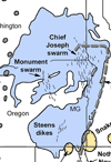
1. The main site of flood-basalt volcanism is located ~400 km north of the western end of the Snake River Plain hotspot track (Figure 1A), suggesting that the origin of the CRFBP is unrelated to that of the Snake River Plain.
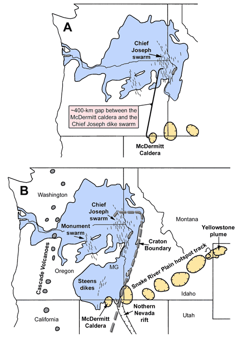
Figure 1. The Columbia River Basalt Province. (A) Original distribution of the CRBG on the Columbia Plateau (Tolan et al., 1989), showing the ~400-km separation between the main source region for the flood-basalts (the Chief Joseph dike swarm) and the proposed initiation site of the Yellowstone hotspot (the McDermitt caldera). (B) The currently accepted distribution of the Columbia River Basalt Group (CRBG) based on the incorporation of Steens Basalt into the CRBG stratigraphy (Camp et al., 2013b). MG = Malheur Gorge. Ovals with tick marks are the felsic calderas of Pierce & Morgan (1992) that progressively increase in age along the Snake River Plain hotspot track, from the McDermitt caldera to Yellowstone. The cratonic boundary separates the Precambrian craton of North America to the east from a thinner basement of Paleozoic and Mesozoic oceanic terranes to the west.
This argument has been resolved by Ar-Ar geochronology and field relations in the Malheur Gorge of eastern Oregon, where Imnaha Basalt of the Columbia River Basalt Group is observed to sit unconformably above Steens Basalts (Hooper et al., 2002; Camp et al., 2003, 2013b). Each of these basalt formations share geochemical and petrographic affinities, as well as a common isotopic component identified by several workers as a plume source (e.g., Hooper & Hawkesworth, 1993; Camp & Hanan, 2008; Wolff & Ramos, 2013). Steens Basalt is now recognized as the oldest formation of the Columbia River Basalt Group (Camp et al., 2013b). The field data demonstrate that flood-basalt volcanism began at ~16.7 Ma, in and near the Steens Mountain dike swarm of southeastern Oregon, at the western end of the Snake River Plain hotspot track (Figure 1B). The main phase of flood-basalt eruption then migrated rapidly to the north where Imnaha and Grande Ronde Basalt erupted from the Chief Joseph dike swarm from ~16.5-15.6 Ma. The fact that earliest flood-basalt began in the same general area as the earliest rhyolites of the Snake River Plain eruptions (~16.5 Ma) provides a strong evidence that the two provinces are genetically related.
2. “Seismic imaging provides no evidence for, and several contraindications of, a vertically extensive plume-like structure beneath Yellowstone” (Christiansen et al., 2002).
The seismic data supporting a deep-mantle source beneath Yellowstone were not forthcoming until recently when a high density of new data from Earthscope's USArray became available. Early data could not readily resolve a plume conduit beneath Yellowstone at a depth >200 km (Iyer et al., 1981 Humprheys & Dueker, 1994; Christiansen et al., 2002). Although a P-wave anomaly extending down into the transition zone (i.e., >410 km depth) beneath Yellowstone was first imaged by Bijwaard et al. (1988) and Montelli et al. (2004), it was more precisely defined by Yuan & Dueker (2005) and Waite et al. (2006) as a low-density plume extending down to at least 500 km. The most recent imagery is more precise and is able to resolve a low-velocity anomaly as a continuous S-shaped conduit interpreted as a mantle plume descending into the lower mantle beneath Yellowstone to a depth of at least 900-1000 km (e.g., Figure 2) (Obrebski et al., 2010, 2011; Humprheys & Schmandt, 2011; Schmandt et al., 2012).
James et al. (2011), however, consider the results to not require a mantle plume. Instead, they suggest that the low-velocity region beneath Yellowstone is consistent with a sheet of upwelling around a partially stranded fragment of the Juan de Fuca plate, possibly including the complementary participation of lower-mantle upwelling.
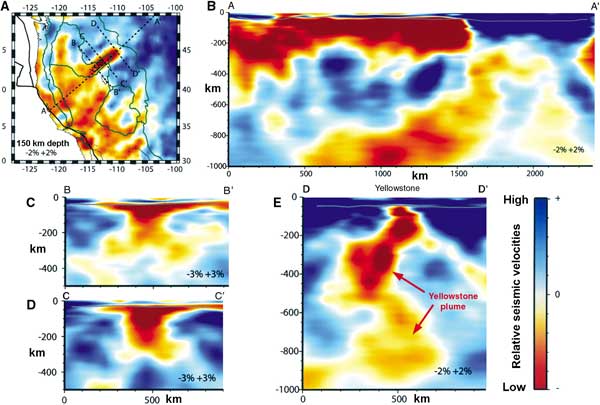
Figure 2: Map view and cross-sections of the Yellowstone mantle anomaly, modified after Obrebski et al. (2011). (A) Color-coded velocity anomalies at 150 km depth, with dashed lines showing the location of vertical slices across the Yellowstone-Snake River. (B-E) Cross-sections. A-A’ and D-D’ (cross-sections B and E) demonstrate that the Yellowstone anomaly is a slow feature that extends continuously from the surface down to at least 1000 km depth. The top of the anomaly in the upper 200-250 km underlies the Yellowstone-Snake River Plain and is elongated in the direction parallel to the absolute motion of the North American plate. The more vertical low velocity anomaly located beneath Yellowstone caldera is defined by Obrebski et al. (2011) as the Yellowstone mantle plume. In cross-section D-D’ (E) the plume weaves its path to the surface around a block of high velocity interpreted by Obrebski et al. (2011) as fragments of the Farallon/Juan de Fuca subducting slab.
3. The Farallon/Juan de Fuca slab would have been an impenetrable barrier to mantle plume ascent.
Recent Earthscope data demonstrate major disruption of the Farallon/Juan de Fuca plate, with broken slab fragments separated by significant gaps or tears (Sigloch et al., 2008; Burdick et al., 2008; Obregski et al., 2010; Schmandt & Humprheys, 2010; Liu & Stegman, 2012). Some workers suggest that breaking of the slab was the result of its interaction with a rising Yellowstone plume, consistent with a hiatus in back-arc volcanism from ~23-17 Ma, a substantial change in plate motion at ~19 Ma (Wilson, 1988), and the initiation of Columbia River flood-basalt volcanism at ~17 Ma (Xue & Allen, 2007; 2010, Obrebski, 2010; Coble & Mahood, 2012). Other workers attribute slab disruption to either plate reorganization or tearing at a shallow hinge zone in the Farallon slab (Schmandt & Humphreys, 2010; Liu & Stegman, 2012). Whatever the cause of fragmentation, a broken and segmented slab removes one of the primary arguments commonly cited against a plume origin for the CRFBP, that the subducting lithosphere would have presented an impenetrable barrier to plume ascent.
Passive- and Active-Mantle Melting Models
The extent to which regional crustal stretching provides the driving mechanism for mantle melting and/or magma ascent is an important consideration in nonplume models of flood-basalt volcanism. In northeastern Oregon and southeastern Washington, where ~90% of the CRBG erupted from the Chief Joseph dike swarm, extensional features coeval with flood-basalt eruption other than the dikes themselves are lacking (Wells, 1990; Hooper et al., 2007). The only evidence of potential extension at the site of the main-phase eruptions of Columbia River Basalt Group, from ~16.7-15.6 Ma, is the combined width of these dikes, which is <<1% of the areal extent of the Chief Joseph dike swarm. In contrast, Colgan & Henry (2009) have shown that the northern Basin-and-Range Province experienced 40-50% extension that began abruptly at ~16-17 Ma, in an area of very minor basalt volcanism. Thus, the area of little or no extension generated the greatest volume of basaltic lava from the Chief Joseph dike swarm, and the area of greatest extension generated only minor volcanism. The eruption of such large volumes of basalt in the absence of substantial crustal rifting, and the lack of significant volcanism in the presence of considerable rifting, is inconsistent with crustal stretching being the driving force for melt generation from adiabatic decompression of solid mantle (McKenzie & Bickle, 1988). Localization of the Columbia River basalt dike swarms, and the lack of additional evidence for significant crustal stretching, suggests further that magma rise during the main-phase eruptions may be the product of forceful dike injection unrelated to a broadly based regime of regional extensional stress.
The lack of field evidence for major crustal stretching during the main phase of flood-basalt eruption rules out the passive mantle decompression-melting origin for the Columbia River Basalt Group. The short duration (1.1 m.y.) of the main-phase lavas, their large volume (~195,500 km3), and their high eruption rate (~0.178 km3/yr) in an area of little or no extension (<<1%) is better explained by decompressional melting associated with an abrupt period of active-mantle upwelling.
Constraints and Conclusions
Regional models describing the genesis of the Columbia River Basalt Group must be consistent with the following constraints:
- the similarity of the ‘Imnaha component’ to oceanic-island basalt in trace-element and isotopic composition (Hooper & Hawkesworth, 1993; Wolff et al., 2008; Wolff & Ramos, 2013),
- the high 3He/4He ratios in Imnaha Basalt (Dodson et al., 1997) and the younger SRP basalts (Graham et al., 2009),
- the abrupt onset, short duration (~1.1 m.y.), and high eruption rate (~0.178 km3/yr) of the main-phase CRBG lavas,
- the high volume of the main-phase lavas (~195,500 km3) erupted during, and in an area of, minimal extension (Hooper et al., 2007),
- migrating trends of basalt eruption from a focused center in the Oregon-Nevada border region (Camp & Ross, 2004), at a rate (~0.4 m/yr) consistent with model simulations of a spreading plume head (d’Acremont et al., 20003),
- a similar, but poorly defined, trend for rhyolites migrating to the north and south, away from the ~16.5 Ma McDermitt-age rhyolites in the Oregon-Nevada border region,
- the subsequent rhyolite age-propagation trend along the SRP hotspot track, in the same direction and at the same rate as plate motion (Pierce & Morgan, 1992),
- the seismic resolution of a low-velocity conduit to a depth of ~900-1000 km beneath Yellowstone at the eastern end of the SRP hotspot track (Obrebski et al., 2010, 2011; Humphreys & Schmandt, 2011),
- deflection of the 660-km discontinuity at the base of the mantle transition zone, where it is dissected by the Yellowstone low-velocity conduit (Bina & Helffrich, 1994; Schmandt et al., 2012),
- the apparent destruction of the Juan de Fuca plate marked by its abrupt termination beneath Oregon at a very shallow depth of ~300 km (Obrebski et al., 2010),
- the field evidence for broad mid-Miocene uplift above the presumed site of mantle upwelling in SE Oregon and adjacent Idaho (Camp, 1995; Pierce et al., 2002; Chamberlain et al., 2012), and perhaps most importantly,
- the spatial and temporal coincidence between the projected location of the postulated Yellowstone plume in the mid-Miocene and the initiation site for flood-basalt eruption at ~16.7 Ma (Camp et al., 2013b), the initiation site for hotspot track volcanism at ~16.5 Ma (e.g., Coble & Mahood, 2012), and the initiation site for the abrupt onset of Basin-and-Range extension at ~16-17 Ma (Colgan & Henry, 2009).
Stress-release models invoking transtensional stress of the plate interior or back-arc extension and a passively rising, decompressing solid mantle as the root cause of flood-basalt volcanism have difficulty explaining these twelve constraints. The geologic evidence appears to be more consistent with a model of active-mantle upwelling, as expected from the adiabatic rise of a deep-mantle plume (e.g., Brandon & Goles, 1988; Draper, 1991; Hooper & Hawkesworth, 1993; Camp & Ross, 2004; Hooper et al., 2007; Camp & Hanan, 2008; Obrebski et al., 2010; Humphreys & Schmandt, 2011; Schmandt et al., 2012).
A shallow-mantle genesis of active upwelling, on the other hand, cannot be dismissed entirely. Small-scale convection of the upper mantle around the truncated edge of the Farallon plate, or through a slab gap, could also provide a viable mechanism consistent with many of these twelve constraints (Roth et al., 2008; Sigloch et al., 2008; Faccenna et al., 2010; James et al., 2011; Liu & Stegman, 2011; Long et al., 2012). Upwelling of shallow mantle, however, is inconsistent with (2), (8), and (9) above. Whereas the heat content of a thermal plume from the core-mantle boundary provides a postulated mechanism for mantle ascent, the driving force for active upwelling of shallow mantle through a tear or gap in the Farallon plate is less clear. Model experiments suggest that slab rollback may be viable as a driving force (Long et al., 2012), but such a model appears to require a coherent plate, which is inconsistent with the broken and fragmented plate noted in a variety of seismic studies (e.g., Sigloch et al., 2008; Burdick et al., 2008; Schmandt & Humphreys, 2010). Whereas small-scale convection of upper mantle around or through the Farallon slab may be a scientifically sound alternative, the prevailing evidence suggests that a deep-mantle plume origin is the only interpretation capable of satisfying all of the twelve constraints cited above.
References
-
Anderson, D.L., 2005, Large igneous provinces, delamination, and fertile mantle: Elements, 1, 271-275.
-
Anderson, D.L., 2007, The eclogite engine: chemical geodynamics as a Galileo thermometer, in Foulger, G.R. and Jurdy, D.M., eds., Plates, Plumes, and Planetary Processes, Geological Society of America Special Paper 430.
-
Bina, C.R., and Helffrich, G., 1994, Phase-transition clapeyron slopes and transition zone seismic discontinuity topography: Journal of Geophysical Research, 99, 15,853-15,860, doi:10.1029/94JB00462.
-
Bijwaard, H., Spakman, W., and Engdahl, E.R., 1998, Closing the gap between regional and global tavel time tomography: Journal of Geophysical Research, 103, 30,055-30,078.
-
Brandon, A.D. and Goles, G.G., 1988, A Miocene subcontinental plume in the Pacific Northwest: geochemical evidence: Earth and Planetary Science Letters, 88, 273-283.
-
Brandon, A.D., and Goles, G.G., 1995, Assessing subcontinental lithospheric mantle sources for basalts: Neogene volcanism in the Pacific Northwest, USA as a test case: Contributions to Mineralogy and Petrology, 121, 364-379.
-
Burdick, S., Li, C., Martynov, V., Cox, T., Eakins, J., Mulder, T., Astiz, L., Vernon, F.L., Pavlis, G.L., and van der Hilst, R.D., Upper mantle heterogeneity beneath North America from travel time tomography with global USArray transportable array data: Seismological Research Letters, 79, 384-392, doi:10.1785/gssrl.79.3.384.
-
Camp, V.E., 1995, Mid-Miocene propagation of the Yellowstone mantle plume head beneath the Columbia River Basalt source region: Geology, 23, 435-438.
-
Camp, V.E., 2013a, Origin of the Columbia River Basalt: Passive rise of shallow mantle, or active upwelling of a deep-mantle plume?, in Reidel, S.P., Camp, V.E., Ross, M.E., Wolff, J.A., Martin, B.S., Tolan, TlL., and Wells, R.E., eds., The Columbia River Basalt Province: Geological Society of America Special Paper 497, doi: 10.1130/2013.2497(07).
-
Camp, V.E. and Ross, M.E., 2004, Mantle dynamics and genesis of mafic magmatism in the intermontane Pacific Northwest: Journal of Geophysical Research, 109, doi:10.1029/2003JB002838.
-
Camp, V.E., and Hanan, B.B., 2008, A plume-triggered delamination origin for the Columbia River Basalt Group: Geosphere, 4, 480-495, doi: 10.1130/GES00175.1.
-
Camp, V.E., Ross, M.E., and Hanson W.E., 2003, Genesis of flood basalts and Basin and Range volcanic rocks from Steens Mountain to the Malheur River Gorge, Oregon: Geological Society of America Bulletin, 115, 105-128.
-
Camp, V.E., Ross, M.E., Duncan, R.A., Jarboe, N.A., Coe, S.C., Hanan, B.B., and Johnson, J.A., 2013b, The Steens Basalt: Earliest lavas of the Columbia River Basalt Group, in Reidel, S.P., Camp, V.E., Ross, M.E., Wolff, J.A., Martin, B.S., Tolan, TlL., and Wells, R.E., eds., The Columbia River Basalt Province: Geological Society of America Special Paper 497, doi: 10.1130/2013.2497(04).
-
Carlson, R.W. and Hart, W.K., 1987, Crustal genesis on the Oregon Plateau, Journal of Geophysical Research, 92, 6191-6206.
-
Chamberlain, C.P., Mix, H.T., Mulch, A., Hren, M.T., Kent-Corson, M.L., Davis, S.J., Horton, T.W., and Graham, S.A., 2012, The Cenozoic climatic and topographic evolution of the western North American Cordillera, American Journal of Science, 312, 213-262, doi 10.2475/02.2012.05.
-
Christiansen, R.L., Foulger, G.R., and Evans, J.R., 2002, Upper mantle origin of the Yellowstone hotspot: Geological Society of America Bulletin, 114, 1245-1256.
-
Coble, M.A., and Mahood, G.A., 2012, Initial impingement of the Yellowstone plume located by widespread silicic volcanism contemporaneous with Columbia River flood basalts, Geology, doi:10.1130/G32692.1
-
Colgan, J.P., and Henry, C.D., 2009, Rapid middle Miocene collapse of the Mesozoic orogenic plateau in north-central Nevada: International Geology review, 51, 920-961, doi: 10.1080/00206810903056731.
-
D’Acremont, E., Leroy, S., and Burov, E.B., 2003, Numerical modeling of a mantle plume: the plume head-lithosphere interaction in the formation of an oceanic large igneous province, Earth and Planetary Science Letters, 206, 379-396, doi:10.1016/S0012-821X(o2)01058-0.
-
Dickinson, W.R., 1997, Overview: Tectonic implications of Cenozoic volcanism in coastal California: Geological Society of America Bulletin, 109, 936-954.
-
Dodson, A., Kennedy, B.M., and DePaolo, D.J., 1997, Helium and neon isotopes in the Imnaha Basalt, Columbia River Basalt Group: evidence for a Yellowstone plume source: Earth and Planetary Science Letters, 150, 443-451.
-
Draper, D.S., 1991, Late Cenozoic bimodal magmatism in the northern Basin and Range Province of southeastern Oregon: Journal of Volcanology and Geothermal Research, 47, 299-328.
-
Dueker, K.G., and Humphreys, E.D., 1994, Western U.S. upper mantle structure, Journal of Geophysical Research, 99, 9615-9634.
-
Duncan, R.A., 1982, A captured island chain in the Coast Range of Oregon and Washington, Journal of Geophysical Research, 87, 10827-10837.
-
Faccenna, C., Becker, T.W., Lallemand, S., Lagabrielle, Y., Funiciello, F., and Piromallo, C., 2010, Subduction-triggered magmatic pulses: a new class of plumes?: Earth and Planetary Science Letters, 299, 54-68, doi:10.1016/j.epsl2010.08.012.
-
Foulger, G.R., 2007, The “Plate” model for the genesis of melting anomalies, in Foulger, G.R. and Jurdy, D.M., eds., Plates, Plumes, and Planetary Processes, Geological Society of America Special Paper 430.
-
Foulger, G.R. and Natland, J.H., 2003, Is “hotspot” volcanism a consequence of plate tectonics?: Science, 300, no. 5621, 921-922, doi:10.1126/science.1083376.
-
Geist, D. and Richards, M., 1993, Origin of the Columbia Plateau and Snake River plain: deflection of the Yellowstone plume: Geology, 21, 789-792.
-
Graham, D.W., Reid, M.R., Jordan, B.T., Grunder, A.L., Leeman, W.P., and Lupton, J.E., 2009, Mantle source provinces beneath the northwestern USA delimited by helium isotopes in young basalts, Journal of Volcanology and Geothermal Research, 199, 128-140, doi:10.1016/j.volgeores.2008.12.004.
-
Hart, W.K., and Carlson, R.W., 1987, Tectonic controls on magma genesis and evolution in the northwestern United States, Journal of Volcanology and Geothermal Research, 32, 119-135.
-
Hooper, P.R., and Hawkesworth, C.J., 1993, Isotopic and geochemical constraints on the origin and evolution of the Columbia River basalt: Journal of Petrology, 34, 1203-1246.
-
Hooper, P.R., Binger, G.B., and Lees, K.R., 2002, Ages of the Steens and Columbia River flood basalts and their relationship to extension-related calc-alkaline volcanism in eastern Oregon: Geological Society of America Bulletin, 114, 43-50.
-
Hooper, P.R., Camp, V.E., Reidel, S.P., and Ross, M.E., 2007, The origin of the Columbia River flood basalt province: Plume versus nonplume models, in Foulger, G.R. and Jurdy, D.M., eds., Plates, Plumes, and Planetary Processes, Geological Society of America Special Paper 430.
-
Humphreys, E.D., and Dueker, K.G., 1994, Western U.S., upper mantle structure: Journal of Geophysical Research, 99, 9615-9634.
-
Iyer, H.M., Evans, J.R., Zandt, G., Stewart, R.M., Coakley, J.M., and Roloff, J.N., 1981, A deep low-velocity body under Yellowstone caldera, Wyoming: Delineation using teleseismic P-wave residuals and tectonic interpretation: Geological Society of America Bulletin, Part II, 922, 1471-1646.
-
James, D.E., Fouch, M.J., Carlson, R.W., and Roth, J.B., 2011, Slab Fragmentation, edge flow and the origin of the Snake River Plain hotspot track, Earth and Planetary Science Letters, doi.10.1016/j.epsl.2011.09.007.
-
King, S.D., and Anderson, D.L., 1995, An alternative mechanism of flood basalt formation: Earth and Planetary Science Letters, 136, 2269-279.
-
Liu, L., and Stegman, D.R., 2012, Origin of Columbia River flood basalt controlled by propagating rupture of the Farallon slab, Nature, 482, 386-389, doi:10.1038/nature/10749.
-
Long, M.D., Till, C.B., Druken, K.A., Calrson, R.W., Wagner, L.S., Fouch, M.J., James, D.E., Grove, T.L., Schmerr, N., Kincaid, C., 2012, Mantle dynamics beneath the Pacific Northwest and the generation of voluminous back-arc volcanism, Geochemistry, Geophysics, and Geosystems, 13, doi: 10.1029/2012GC004189.
-
Lustrino, M., 2005, How the delamination and detachment of lower crust can influence basaltic magmatism: Earth Science Review, 72, doi: 10.1016/j.earscirev.2005.03.004.
-
McKenzie, D., Bickle, M.J., 1988, The volume and composition of melt generated by extension of lithosphere, Journal of Petrology, 29, 625-679.
-
Montelli, R., Notlet, G., Dahlen, F., Masters, G., Engdahl, E.R., Haung, S.H., 2004, Finite-frequency tomography reveals a variety of plumes in the mantle: Science, 303, 338-343, doi:10.1126/science.1092485.
-
Obrebski, M., Allen, R.M., Xue, M., and Hung, S-H., 2010, Slab-plume interaction beneath the Pacific Northwest: Geophysical Research Letters, 37, L14305, doi:10.1029/2010GL043489.
-
Obrebski, M., Allen, R.M., Pollitz, F., and Hung, S-H., 2011, Lithosphere-asthenosphere interaction beneath the western United States from joint inversion of body-wave traveltimes and surface-wave phase velocities: Geophysical Journal International, 185, 1003-1021, doi: 10.1111/j.1365-246X.2011.04990.x.
-
Pierce, K.L. and Morgan, L.A., 1992, The track of the Yellowstone hot spot: volcanism, faulting, and uplift, in Regional geology of eastern Idaho and western Wyoming, in Link, P.K., ed., Regional Geology of Eastern Idaho and Western Wyoming: Geological Society of America Memoir 179, 1-53.
-
Schmandt, B., and Humphreys, E.D., 2010, Complex subduction and small-scale convection revealed by body-wave tomography of the western United States upper mantle, Earth and Planetary Science Letters, 297, 435-445, doi:10.1016/j.epsl.2010.06.047
-
Schmandt, B., Dueker, K., Humphreys, E., and Hansen, S., 2012, Hot mantle upwelling across the 660 beneath Yellowstone: Earth and Planetary Science Letters, 331, 224-236, doi:10.1016/j.epsl.2012.03.025.
-
Sigloch, K., McQuarrie, N., and Nolet, G., 2008, Two-stage subduction history under North America inferred from multiple-frequency tomography: Nature Geoscience, 1, 458-462, doi:10.1038/ngeo231.
-
Smith, A.D., 1992, Back-arc convection model for Columbia River Basalt genesis, Tectonophysics, 207, 269-285.
-
Tikoff, B., Benford, B., and Giorgis, S., 2008, Lithospheric control on the initiation of the Yellowstone hotspot: chronic reactivation of lithospheric scars: International Geology Review, 50, 305-324, doi:10.2747/0020-6814.50.3.305.
-
Tolan, T.L., Reidel, S.P., Hooper, P.R., Beeson, M.H., Fecht, K.R., Bentley, R.D., and Anderson, J.L., 1989, Revisions to the estimates of the areal extent and volume of the Columbia River basalt group, in Reidel, S.P., and Hooper, P.R., eds., Volcanism and tectonism in the Columbia River flood-basalt province: Geological Society of America Special Paper 239, 1-20.
-
Waite, G.P., Smith, R.B., and Allen, R.M., 2006, Vp and Vs structure of the Yellowstone hot spot from teleseismic tomography: evidence for an upper mantle plume: Journal of Geophysical Research, 111, B04303, doi: 10.1029/2005JB003867.
-
Wells, R.E., 1990, Paleomagnetic rotations and the Cenozoic tectonics of the Cascade Range, Washington, Oregon, and California: Journal of Geophysical Research, 95, 19,409-19,417.
-
Wilson,D.S., 1988, Tectonic history of the Juan de Fuca Ridge over the last 40 million years: Journal of Geophysical Research, 93, 11,863-11,876, doi:10.1029/JB093iB10p11863.
-
Wolff, J.A. and Ramos, F.C., 2013, Source materials for the main phase of the Columbia River Basalt Group: geochemical evidence and implications for magma storage and transport, in Reidel, S.P., Camp, V.E., Ross, M.E.,
-
Wolff, J.A., Martin, B.S., Tolan, TlL., and Wells, R.E., eds., The Columbia River Basalt Province: Geological Society of Ameica Speical Paper 497, doi: 10.1130/2013.2497(11).
-
Wolff, J.A., Ramos, F.C., Hart, G.L., and Patterson, J.D., and Brandon, A.D., 2008, Columbia River flood basalts from a centralized crustal magmatic system: Nature Geoscience, www.nature.com/naturegeoscience, February, 1, 177-180, doi:10.1038.ngeo124.
-
Xue, M., and Allen, R.M., 2007, The fate of the Juan de Fuca plate: Implications for a Yellowstone plume head: Earth and Planetary Science Letters, 264, 266-276, doi:10.1016/j.espl.2007.09.047.
-
Xue, M., and Allen, R.M., 2010, Mantle structure beneath the western United States and its implications for convection processes: Journal of Geophysical Research, 115, B07303, doi:10.1028JB006079.
-
Yuan, H., and Dueker, 2005, Teleseismic P-wave tomography of the Yellowstone plume: Geophysical Research Letters, 32, L-7304, doi:10.1029/2004GL022056.
last updated 23rd
January, 2014 |