 |
Curious styles of spreading in and around Iceland |
Gillian
R. Foulger
Dept.
Geological Sciences, University of Durham, Durham
DH1 3LE, U.K.
g.r.foulger@durham.ac.uk
Summary
At its broadest, Iceland is ~ 500 km wide in the local spreading direction, N105°E (Figure 1). Since the local spreading rate is ~ 2 cm/year, the landmass must thus have taken ~ 25 Ma to form, if it is all oceanic. However, the oldest lavas exposed on land are ~ 16 Ma. These simple observations require that a buried microplate lies beneath younger surface lavas and that its extent in the spreading direction is ~ 200 km [Foulger, 2006].
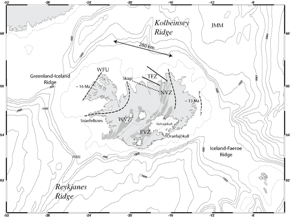
Figure 1: Map of the Iceland region showing bathymetric contours and tectonic features. Thin lines on land: outlines of neovolcanic zones, dark grey: spreading segments, white: glaciers. WVZ, EVZ, NVZ: Western, Eastern, Northern Volcanic Zones, TFZ: Tjörnes Fracture Zone. Individual faults are shown by lines, dotted where uncertain. Dashed lines: extinct rift zones (two in west Iceland and two in east Iceland), WFU: Western Fjords Unconformity. Lavas northwest of this unconformity formed at an extinct rift that lies offshore. Line with arrowheads: the width of oceanic crust predicted to separate the 16 and 13 Ma isochrons, given a ~ 2 cm/a full spreading rate. This is much less than the distance between the outcrops, measured in the spreading direction. JMM: Jan Mayen microcontinent [from Foulger, 2006].
Examination of the shape of the island indicates that this microplate must be at least 150 km in north-south extent and ~ 31,500 km2 in area (Figure 2). This conclusion is unambiguous, and not affected by any considerations regarding spreading ridge migrations, jumps, the simultaneous existence of multiple active ridges, three-dimensionality, or subsidence of the lava pile [Palmason, 1963]. Such complexities bear on the distribution and age of the older crust, but not on its existence or its width.
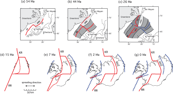
Figure 2: Tectonic evolution of the Iceland region during the past 54 Ma. Red lines–currently active plate boundaries; dashed red lines–imminent plate boundaries; dashed blue lines–extinct plate boundaries; thin lines–bathymetric contours; JMM–Jan Mayen microcontinent; KR–Kolbeinsey Ridge; N–Norway; NVZ–Northern Volcanic Zone; RR–Reykjanes Ridge, AR–Aegir Ridge [from Foulger, 2010].
This simple fact is, however, widely misunderstood or ignored. Mention of the subject is commonly limited to pointing out that a little continental crust may have been been captured beneath Iceland. Geochemical evidence for this includes elevated 87Sr/86Sr and Pb isotope ratios in material from southeast Iceland [Prestvik et al., 2001; Torsvik et al., 2015] and reports of zircons of Archaean and Jurassic age. The zircon work has been reported in two conference abstracts [Paquette et al., 2006; Schaltegger et al., 2002] and the lack of followup of these remarkable findings is a significant omission.
This continental crust might be a thin southerly extension of the Jan Mayen microcontinent which lies submerged beneath the ocean to the northeast of Iceland (Figure 1). Alternatively, it could be a separate continental microplate that broke off Greenland during the opening of the north Atlantic. The latter scenario is perhaps the most likely since the geochemical evidence for recycled continental crust is from the far south of Iceland and has not been reported from localities further north. Such a microplate would not be out of the ordinary in this region, which is strewn with such blocks including the Faeroe block, Jan Mayen microcontinent and the Hatton Bank.
It is nevertheless extremely unlikely that the entire 31,500 km2 of the microplate under Iceland is continental since more widespread geochemical evidence would then be expected. A large oceanic microplate in the form of one or more blocks must also have been captured. The existence of this microplate is almost universally ignored. It is not predicted by the plume hypothesis, though like all observations and their inverses, ad hoc or assertive attributions for it in the plume context can easily be made [e.g., Martin et al., 2011]. Ignoring it will, however, not make it go away.
Investigating where the captured oceanic crust may lie is another problem that has not yet been addressed. It contributes to the crustal layer beneath Iceland and to making the Icelandic crust appear anomalously thick compared with oceanic crust. Its most likely location is beneath central Iceland, where seismology shows that the crust is up to 10 km thicker than beneath most of the rest of Iceland (Figure 3). It has significant implications for the magmatic rate in Iceland, implying that it is less than might be calculated if it is assumed that the whole of the layer with crust-llike seismic wave-speeds was produced in the last ~ 16 Ma [see Foulger et al., 2003 for more details].
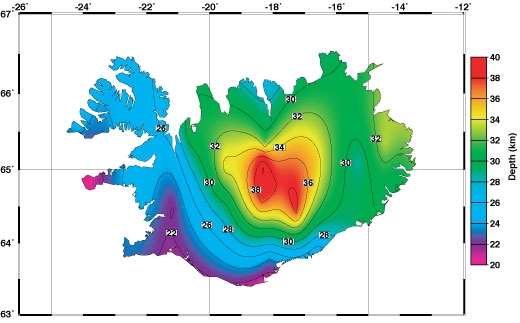
Figure 3: Seismic crustal thickness [from Foulger et al. 2003].
Migrating ridges
On the scale of entire volcanic zones
Icelandic-type crust underlies both the Greenland-Iceland ridge and the Iceland-Faeroe ridge, symmetrically about the mid-Atlantic ridge (Figure 1). This suggests that the locus of excess volcanism has been centred more or less on the spreading ridge for the entire history of the opening of the north Atlantic (Lundin & Doré, 2005; http://www.mantleplumes.org/Iceland2.html). Superimposed on this simple picture, the detailed configuration of spreading ridges in and around Iceland has been chronically unstable. Despite many decades of research there is, however, still a lack of clarity regarding the details.
A parallel pair of spreading axes has existed within and/or close to Iceland for at least 44 Ma (Figure 2). Axes have formed, become extinct, and the locus of spreading migrated with time. Rift migrations have proceeded both to the east and to the west. Offshore to the north of Iceland, spreading along the Aegir ridge to the east became progressively extinct from south to north at ~ 26 Ma and was transferred first to the more westerly Iceland Plateau rift and subsequently to the Kolbeinsey ridge even further west [Foulger et al., 2005; Brandsdottir et al., 2015].
Despite the evidence, it has been erroneously claimed and widely repeated that spreading has always proceeded along a single rift that migrated east. The expectation for such behaviour may originate in the work of Lawver & Muller [1994] and later authors, who calculate where a plume track would lie if a plume fixed relative to other postulated plumes were centred beneath southeast Iceland. The calculated, postulated track ages to the west from Iceland to central Greenland.
There is, however, no evidence for such a track. Volcanism has always been centred on the mid-Atlantic ridge, and the suggestion that the axis of spreading in and around Iceland migrated east is not correct (http://www.mantleplumes.org/Iceland2.html). Radiometric ages, regional isochrons, unconformities, tectonic relationships, regional dip of lavas, deformation associated with the Tjörnes Fracture Zone and tectonic reconstructions require that spreading has proceeded along multiple zones, not a single zone, for tens of millions of years [Foulger, 2006; 2010]. This region thus comprises a diffuse spreading plate boundary. The picture is consistent with the long-term existence of an eastern embayment of the mid-Atlantic ridge that is chronically unstable, with multiple segments that migrate or jump laterally and form by longitudinal propagation [see also Martin et al., 2011].
On the scale of individual spreading segments
The Reykjanes ridge south of Iceland and the Kolbeinsey ridge north of Iceland are flanked by “chevron” or “V-shaped” ridges of slightly thickened crust [Jones et al., 2002; Vogt, 1971]. These are most clearly visible in the gravity field (Figure 4). They comprise swathes where the oceanic crust is ~ 2 km thicker than the adjacent crust and it appears they have formed by the south-and north-ward propagation of loci of enhanced magma generation.
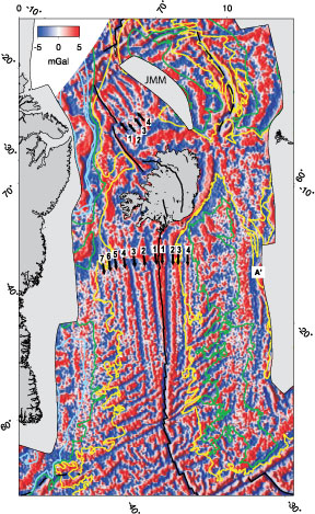
Figure 4: Free-air gravity field of the Reykjanes ridge and Iceland region showing the chevron ridges [from Jones et al., 2002].
Two theories have been proposed to explain them:
- Temperature pulses occur every ~ 5 Ma in a plume located beneath southeast Iceland, generating packages of unusually hot asthenosphere that barrel along the underside of the mid-Atlantic ridge like gutter balls, enhancing melt production as they pass [e.g., Ito, 2001];
- Passage of the tips of propagating ridge segments, travelling at ~ 25 cm/a, and accompanied by enhanced melt production [Benediktsdóttir et al., 2012; Hey et al., 2010; see also http://www.mantleplumes.org/Disclosure.html and http://www.mantleplumes.org/RR_VSRs.html].
The first explanation is ad hoc and enjoys no convincing supporting evidence. The second is supported by observational evidence in the form of bathymetric and geophysical observations from the sea floor (Figure 5). It is not disputed that the propagators exist. The mechanism by which enhanced melting occurs has not yet been explained, however, and remains another important, unaddressed problem.
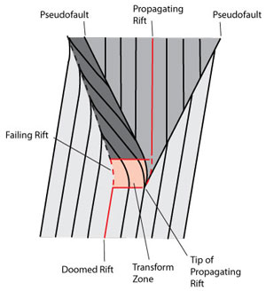 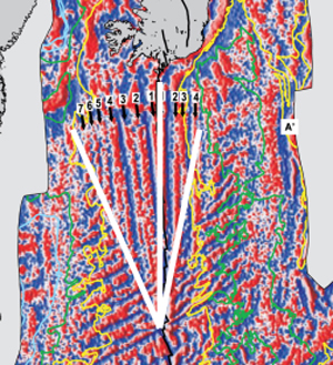
Figure 5: Left: Schematic diagram of a propagating-dying rift pair illustrating why the related seafloor fabric appears wider on one flank than the other. See http://www.soest.hawaii.edu/HIGP/Faculty/hey/propagation.html for more examples. Right: Free-air gravity field of the Reykjanes ridge showing that this feature is observed there.
In addition to the small-scale propagators on the Reykjanes and Kolbeinsey ridges, propagating ridges also occur both on a large scale north of Iceland, and in Iceland itself. The extinct Aegir spreading centre north of Iceland grew southward as it formed. The ages of central volcanoes that formed in a proto-northern volcanic zone in Iceland (Figure 1) young to the south, suggesting that this volcanic zone propagated south as it developed [Martin et al., 2011]. The volcanic rate, width of the rift zone and crustal thickness all increase southerly along this zone, which culminates in a cluster of huge central volcanoes–the Kverkfjöll, Bardárbunga and Grimsvötn volcanoes. This is consistent with enhanced melt production at the rift tip. The same is true for the eastern volcanic zone, in south Iceland, which formed at ~ 2 Ma and which is tipped at its southern end by large volcanoes and high topography in the form of the Myrdalsjökull and Eyjafjallajökull volcanoes.
Discussion
Many published papers about the Iceland region repeat misconceptions that appear to arise from trying to make observations fit the plume hypothesis. The model of an eastward-migrating Icelandic plume has not been developed to explain observations from the region–the reverse process has taken place. The model arose from calculation of where a volcanic track would lie if a relatively fixed plume existed under Iceland. Subsequently, observations from Iceland have been selectively quoted a posteriori to bolster up this model. It has become widely assumed that eastward migration of the most intense volcanic locus did occur despite the absence of a Hawaiian-like volcanic chain and despite evidence that magmatism has been centred on the mid-Atlantic ridge since the opening of the ocean. Curiously, it has also been claimed that westward migration of rift zones north of Iceland is evidence for an eastward-migrating plume [e.g., Brandsdottir et al., 2015].
Light-rare-earth enrichment in Icelandic basalts does not prove that they were produced by a plume. This geochemical signature has, for over 30 years, been essentially universally attributed by geochemists to a component of recycled near-surface materials in the melt source [e.g., Hofmann & White, 1982]. The distribution of ages of basalts in Iceland cannot be explained simply by rift migration. Features that are unexplained by the plume hypothesis such as the existence of a large oceanic microplate, and recent volcanism in the Snaefellsnes volcanic zone, 300 km west of the presumed plume centre (Figure 2), tend to be rarely mentioned and little studied, to the detriment of a fuller understanding of the region.
Ad hoc plume variants that have been proposed to match complex observations include pulsing, switching on and off, chanelling flow beneath rifts or not, lower-crustal flow, temperature pulses, geochemical provincialisation, tilting, mantle wind, and a plume becoming seismically invisible just below 650 km depth. Many of these characteristics cannot be tested, and they may or may not be proposed for other postulated plumes, depending on whether they are thought to be required or not. Seismic tomography is of limited help because the repeatability between studies is poor. For example, core-mantle-boundary plume roots have been proposed variously to lie southwest of Iceland [Bijwaard & Spakman, 1999], beneath the Iceland-Faeroe ridge [Helmberger et al., 1998], the English channel [Rickers et al., 2013], and, unusually, directly beneath Iceland itself [He et al., 2015] (Figure 6).
Figure 6: Localities beneath whyich an Iceland plume root has been asserted to lie at the core-mantle boundary, in recent seismological studies [Helmberger et al., 1998; Bijwaard & Spakman, 1999; Rickers et al., 2013; He et al., 2015].
Even a bespoke plume cannot, however, except by assertion explain many curious observations. These include:
- Why is there a submerged microplate under Iceland? Where does it lie?
- Why is the Snaefellsnes zone volcanically active (Figure 1)?
- Why are there rift propagators travelling north and south away from Iceland?
- Why do spreading zones migrate west and east in Iceland?
- Why does the mid-Atlantic ridge change trajectory at Iceland?
- Why does the Greenland-Iceland-Faeroe ridge coincide with the Iapetus frontal thrust?
- Why is the history of spreading different north and south of Iceland?
- What is the nature of the layer attributed to seismic “lower crust”?
- Why does Iceland have such low topography when isostatic considerations predict it should stand ~ 4 km high?
- What is the magmatic rate at Iceland?
Although the Iceland region has been studied intensively by hundreds of Earth scientists for decades, enigmatic unsolved problems still remain uninvestigated. They suggest that remarkable new findings are still to be unearthed, with equally remarkable implications for how plate tectonics works in this unusual place.
References
-
-
Bijwaard, H., and W. Spakman (1999), Tomographic evidence for a narrow whole mantle plume below Iceland, Earth planet. Sci. Lett., 166, 121-126.
-
Brandsdottir, B., E. E. E. Hooft, and Y. Murai (2015), Origin and evolution of the Kolbeinsey Ridge and Iceland Plateau, N-Atlantic,Geochem. Geophys. Geosys., 16, 612-634, 10.1002/2014GC005540.
-
-
-
-
-
He, Y., L. Wen, Y. Capdeville, and L. Zhao (2015), Seismic evidence for an Iceland thermo-chemical plume in the Earth's lowermost mantle, Earth planet. Sci. Lett., 417, 19-27.
-
Helmberger, D. V., L. Wen, and X. Ding (1998), Seismic evidence that the source of the Iceland hotspot lies at the core-mantle boundary, Nature, 396, 251-255.
-
-
Hofmann, A. W., and W. M. White (1982), Mantle plumes from ancient oceanic crust, Earth planet. Sci. Lett., 57, 421-436
-
Ito, G. (2001), Reykjanes 'V'-shaped ridges originating from a pulsing and dehydrating mantle plume, Nature, 411(6838), 681-684.
-
Jones, S. M., N. White, and J. Maclennan (2002), V-shaped ridges around Iceland; implications for spatial and temporal patterns of mantle convection, Geochem. Geophys. Geosys., 3(10), 2002GC000361.
-
Lawver, L. A., and R. D. Muller (1994), Iceland hotspot track, Geology, 22, 311-314.
-
Lundin, E., and Doré, T., 2005, The fixity of the Iceland "hotspot" on the Mid-Atlantic Ridge: observational evidence, mechanisms and implications for Atlantic volcanic margins, in Foulger, G. R., J.H. Natland, D.C. Presnall and D.L. Anderson, ed., Plates, Plumes, and Paradigms, Volume Special Paper 388, Geological Society of America, p. 627-652.
-
Martin, E., J. L. Paquette, V. Bosse, G. Ruffet, M. Tiepolo, and O. Sigmarsson (2011), Geodynamics of rift–plume interaction in Iceland as constrained by new 40Ar/39Ar and in situ U–Pb zircon ages, Earth planet. Sci. Lett., 311, 28-38.
-
Palmason, G. (1963), Seismic refraction investigation of the basalt lavas in northern and eastern Iceland, Jökull, 13, 40-60.
-
Paquette, J., O. Sigmarsson, and M. Tiepolo (2006), Continental basement under Iceland revealed by old zircons, paper presented at American Geophysical Union, Fall Meeting.
-
Prestvik, T., S. Goldberg, H. Karlsson, and K. Gronvold (2001), Anomalous strontium and lead isotope signatures in the off-rift Oraefajokull central volcano in south-east Iceland. Evidence for enriched endmember(s) of the Iceland mantle plume?, Earth planet. Sci. Lett., 190(3-4), 211-220.
-
Rickers, F., A. Fichtner, and J. Trampert (2013), The Iceland–Jan Mayen plume system and its impact on mantle dynamics in the North Atlantic region: Evidence from full-waveform inversion, Earth planet. Sci. Lett., 367, 39-51.
-
Schaltegger, U., H. E. F. Amundsen, B. Jamtveit, et al. (2002), Contamination of OIB by underlying ancient continental lithosphere: U-Pb and Hf isotopes in zircons question EM1 and EM2 mantle components, Geochim. Cosmochim. Acta, 66(15A), A673.
-
-
Vogt, P. R. (1971), Asthenosphere motion recorded by the ocean floor south of Iceland, Earth planet. Sci. Lett., 13, 153-160.
last updated 3rd June, 2015 |