|
|
Is
there any relation between the Hawaiian-Emperor
seamount chain bend at 43 Ma and the evolution
of the Kamchatka continental margin? |
|
M.N.
Shapiro1, A.V.
Soloviev2 and G.V.
Ledneva2
1Institute
of Earth Physics of the Russian Academy of Sciences,
10, Bolshaya Gruzinskaya st., Moscow, 123810, Russia,
mns@ifz.ru
2Geological
Institute of the Russia Academy of Sciences, 7, Pyzhevsky
per., Moscow, 119017, Russia, solov@ilran.ru & ledneva@ilran.ru
 Click here to
download a PDF version of this webpage Click here to
download a PDF version of this webpage
Introduction
and statement of the problem
The Hawaiian-Emperor volcanic
chain is considered to be the trail of the Hawaiian
hotspot, still active at the present day (Figure 1A).
Based on deep-sea drilling data, the structure and evolution
of the chain can be reconstructed from the early Campanian
when the Meiji Seamount (also called the Obruchev Rise),
representing northernmost terminus of the Emperor Seamounts,
was formed [Creager et al., 1973; Rea et
al., 1995; Tarduno et al., 2002]. At that
time the Hawaiian hotspot was located at ~5-10°
to the north and somewhat to the east of its present
position [Shapiro, 2005].
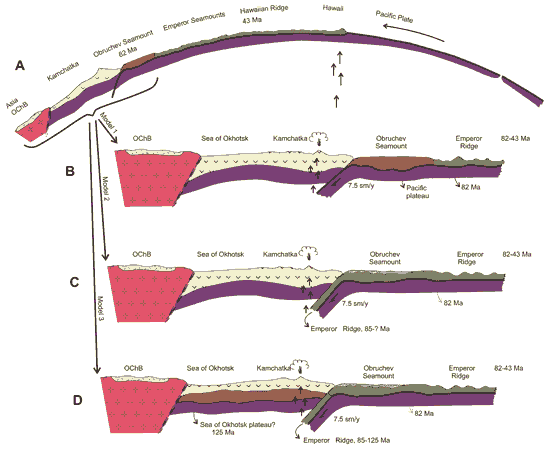
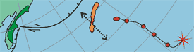
Figure 1: Profiles
demonstrating possible relationships between the Emperor
Seamounts and Eurasia.
Scheme A demonstrates the principal relationships between
the main modern structures of the northwestern Pacific
Ocean. The oceanic lithosphere (purple) and crust (thick
black line) originated at the East Pacific Rise and
then moved over the Hawaiian hotspot (plume), which
resulted in formation of the Hawaiian-Emperor volcanic
chain (vertical shading on green). In the northwest
the chain is limited by the Obruchev Rise (also called
the Meiji Seamount), which can be considered as the
leading sector of the volcanic chain (lattice shading
on brown). Structures of Kamchatka (yellow) presumably
underlain by reworked oceanic crust are located further
to the northwest. Kamchatka and the Obruchev Rise are
separated by the active subduction zone. Another extinct
subduction zone, which has been little studied, probably
separates the structures of Kamchatka from continental
structures overlapped by the Okhotsk-Chukchi subduction-related
volcanic belt (OChB).
Schemes B, C and D (all corresponding to the northwestern
fragment of Scheme A) show possible relationships between
the Emperor Seamounts and Kamchatka structures, which
are discussed in the text. Click here
or on figure for enlargement.
A peculiar feature of
the Hawaiian-Emperor volcanic chain is its sharp 60°
bend which is widely interpreted as the result of a
major shift in the direction of movement of the Pacific
plate at about 43 Ma [Ed:
The most recent estimate of the age of the bend is 47
Ma. See also Hawaii page
for discussion of the hypothesised change in Pacific
plate motion at the time of the bend.] Alternatively,
some researchers explain this bend as due to drift of
the Hawaiian hotspot [Norton, 1995] or interaction
of the oldest northernmost sections of the Emperor Seamounts
with the northeastern Asian mainland [Niu et al.,
2003]. At present the northern terminus of the Emperor
Seamounts is the Obruchev Rise, which only recently
began subducting into the northern Kurile-Kamchatka
Trench [Seliverstov, 1998].
Simplistic models of interaction
of the Emperor Seamounts with the Asian mainland are
as follows:
-
If the Hawaiian
hotspot formed only in the early Campanian then
the Obruchev Rise is the initial, plume-head plateau
of the Emperor Seamounts (Figure 1B). In this
case, there was no collision of the Emperor Seamounts
and the Obruchev Rise in particular with the Asian
mainland and this collision could not result in
a change in the direction of movement of the Pacific
plate at ~43 Ma.
-
If any former
north continuation of the Emperor Seamounts was
older than the Obruchev Rise, it might be subducted
(Fig. 1C). However, if subduction of these oldest
chain sections did not meet with obstacles than
this process could not have resulted in a change
in direction of movement of the Pacific plate at
~43 Ma.
-
A major change
in the direction of motion of the Pacific plate
is possible only if a ridge, most probably an oceanic
plume-head plateau, was too buoyant to subduct (Fig.
1D). According to this hypothesis the oldest
section of the Emperor Seamounts drifted atop of
the Pacific plate and later docked with the Asian
mainland, but could not subduct. In this case, some
of the oldest fragments of the Emperor Seamounts
located between the Obruchev Rise and the northernmost
terminus of the volcanic chain would be preserved
on the northeastern Asian continental margin. Thus,
this model can be tested by geological investigations.
The main problem is locating
where a possible continuation of the Emperor Seamounts
would lie on the Asian mainland. The most promising
area is Kamchatka, whose coast the Emperor Seamounts
currently approach. Nonetheless, taking into consideration
that at ~43 Ma the Obruchev Rise was located at 40°N
and 140°W [Engebretson et al., 1985] a
structural relationship between the Hawaiian-Emperor
volcanic chain and Kamchatka at 60°N and 180°W
at that time is not so obvious (Figure 2).
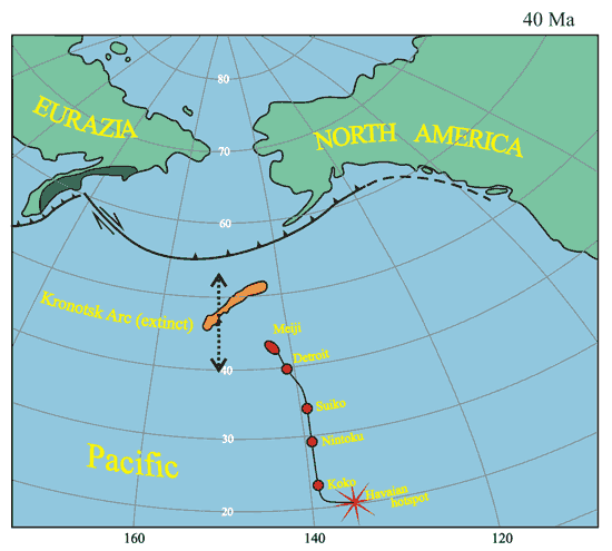
Figure 2: Northern
Pacific at 43 Ma. The Achaivayam-Valaginsky arc accreted
at the time to the mainland is shown in dark green.
The extinct Kronotsky-Komandorsky arc (orange), which
was located northwest of the Achaivayam-Valaginsky arc
at the time, separated the Emperor Seamounts from Kamchatka.
The position of the Hawaiian hotspot coincides with
its modern position; the Emperor Seamount chain trended
to the north of the Hawaiian hotspot (red circles).
The average paleomagnetic latitude of the Kronotsky
Arc in the Bartonian is shown by the arrow [Levashova
et al., 2000].
If the Emperor Seamounts
continue to the north-northwest, beyond the well-known
chain that is preserved on the sea floor, than this
continuation must have been subducted beneath the Aleutian
arc and then transported along dextral strike-slip faults
in the basement of the Aleutian arc after 43 Ma.
A continuation of the
Emperor Seamounts can be found in Kamchatka only if
the trend of the volcanic chain coincided with the trend
of the Obruchev Rise. It should be emphasized that accreted
fragments of the Emperor Seamounts should be located
along the northwestern continuation of the Obruchev
Rise strike because the Pacific plate south of the Aleutian
arc has subducted orthogonally beneath the Kamchatka
Trench since 43 Ma. Large strike-slip faults parallel
to the trench, along which a continuation of the Emperor
Seamounts could have been transported to the southwest
or to the northeast of Kamchatka have not existed in
the region since 43 Ma. Thus, the remnant of a hypothetical
pre-Campanian section of the Emperor volcanic chain
can only exist in the central Kamchatka Peninsula.
Are
remnants of the Emperor chain preserved in Kamchatka
or not?
The geological structure
of Kamchatka and the Southern Koryak Highlands (Figure
3) is characterised by weakly deformed modern volcanic
belts (a), depressions mainly filled with Cenozoic (middle
Eocene – Pliocene) terrigenous sediments (b) and
uplifts composed of strongly deformed pre-middle Eocene
complexes (c). Pre-Campanian deposits of the Emperor
volcanic chain could relate only to the uplifts. Based
on the structure of these uplifts, four tectonostratigraphic
terranes composing the basement of the Kamchatka Peninsula
can be distinguished.
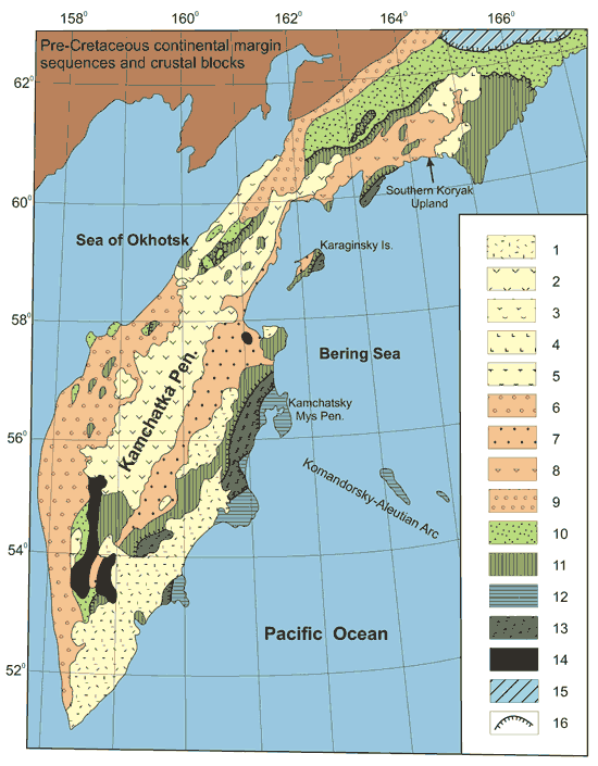
Figure 3: Sketch of
the tectonic zoning of Kamchatka. Slightly deformed
Cenozoic volcanic belts: 1 – Eastern Kamchatka,
2 – Central Kamchatka (Sredinny Range), 3 –
Kinkil’ (Western Kamchatka), 4 – Apuka and
Vyvenka areas in the Southern Koryak Highlands, 5 –
Cherepanovka area in the south of the Sredinny Range.
Depressions, those filled with slightly and moderately
deformed deposits of the middle Eocene – Pliocene:
Western Kamchatka - 6, Central Kamchatka - 7, Ilpi-Pakhacha
- 8, 9 – Pustoretsk-Parapolsk ones. Terranes exposed
within uplifts: 10 – Omgon-Ukelayat, 11 –
Achaivayam-Valaginsky, 12 – Kronotsky, 13 –
Vetlovka, 14 – metamorphics after deposits of
the Omgon-Ukelayat and Achaivayam-Valaginsky terranes,
15 – terranes of the northern Koryak Highlands.
16 – largest thrusts.
The Omgon-Ukelayat terrane
occupies the northwest of the Olyutorsky - Kamchatka
region and is dominated by strongly deformed sandy and
flysch deposits dated at the middle Cretaceous to earliest
middle Eocene [Ermakov & Suprunenko,
1975; Garver
et al.,
2000; Soloviev
et al.,
2006; in press]. The sediments are subarkosic in
composition, reflecting derivation of terrigenous material
from the Asian continental margin [Shapiro et al.,
1993, 2001].
These terrigenous sediments locally contain lenses of
pillow MORBs. Sediments of the Omgon-Ukelayat terrane
were deposited along the Asian continental margin, which
bordered on a marginal sea basin to the southeast. This
terrane did not experience significant movements relative
to the Asian mainland. Neither deposits of the Omgon-Ukelayat
terrane nor its section can be correlated with volcanics
generated above a plume or with the sediments overlying
an intraplate oceanic plateau.
The Achaivayam-Valaginsky
terrane is located to the east of the Omgon-Ukelayat
terrane [Shapiro, 1995]. It includes both large
uplifts in Kamchatka (the Sredinny and Eastern Ranges),
the Olyutorsky zone (the Vetvey and Olyutorsky Ranges,
the Olyutorsky Peninsula) and small windows in the basement
of western Kamchatka and the Ilpi-Pakhacha depression
in the Olyutorsky zone. These uplifts are mainly composed
of upper Cretaceous – lower Paleocene volcanic-sedimentary
complexes that are locally dominated by medium-K and
high-K calc-alkaline basaltic andesites, andesites and,
less commonly, dacites that are geochemically similar
to island-arc volcanics (Figure 4). These deposits are
interpreted as proximal facies of the volcanic edifices
of island arcs.
Other upper Cretaceous
– lower Paleocene sequences both overlying and
underlying the volcanic facies of island arcs are represented
by bedded fine- and medium-grained tuffs of a mixed
composition intercalated with cherty-silty sediments.
Lavas associated with these sediments are island-arc
tholeiites (Figure 4) indicating that these rocks were
deposited in a volcanic arc environment. The sequences
dominated by red-wax jaspers commonly contain intraplate
tholeiites (Figure 4) that might represent the basement
of the arc.
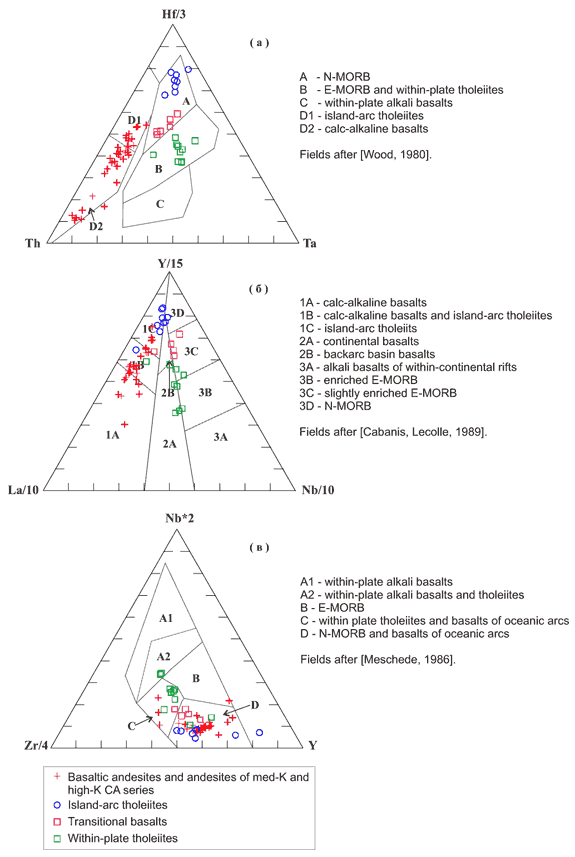
Figure 4: Discrimination
diagrams for upper Cretaceous – lower Paleogene
volcanics of the Achaivayam-Valaginsky terrane.
Pre-Campanian igneous
and sedimentary rocks in the Achaivayam-Valaginsky terrane
are quite rare. These deposits are either tuffs or silts
resembling younger Campanian-Paleocene sequences of
the same composition [Bragin et al., 1986;
Sukhov & Kuzmichev, 2005] or Jurassic-Maastrichtian
radiolarites [Kurilov, 2005]. In Kamchatka
Isthmus and the Olyutorsky Range island-arc complexes
rest on tectonic nappes composed of pillow MORB-like
aphyric basalts with lenses of Albian-Cenomanian red
jaspers [Bogdanov et al., 1987; Soloviev
et al.,
2002a].
The Kamchatka Peninsula
in its southern (the Ganaly Range, Malka Uplift) and
central (the Havyvenka Uplift) parts is composed of
metamorphic rocks that were until recently considered
the basement of the Campanian-Paleocene island-arc complexes.
These metamorphics were formed following terrigenous
and volcanic deposits, whose composition differs drastically
from the composition of Hawaiian-Emperor Seamount rocks.
Moreover, SHRIMP dates of zircons indicate that most
metamorphosed terrigenous rocks and volcanics of the
Kamchatka Peninsula are early Cretaceous-Paleocene and
Campanian-Maastrichtian in age, respectively [Hourigan
et al.,
in review; Soloviev & Palechek, 2004].
The Omgon-Ukelayat and
Achaivayam-Valaginsky terranes are separated by a regional
suture along which arc volcanics thrust over terrigenous
deposits of the Asian continental margin. This suture
resulted from arc-continent collision and formed at
50 Ma in the south and 45 Ma in the north [Hourigan
et al.,
in review; Soloviev et al., 2002a,
2002b].
It is possible that this collision might have affected
the kinematics of the Pacific plate. However, it occurred
between the volcanic arc and the continent, and not
between a continuation of the Emperor Seamounts and
the continent. This arc-continent collision is not related
to termination of volcanic activity in the Okhotsk-Chukchi
volcanic belt, where arc magmatism ceased in the middle
Campanian [Filatova, 1987]. The provenance
of zircons with single-grain fission-track ages of 44
Ma and older [Garver
et al.,
2000; Niu et al., 2003] is still disputed
but derivation from subduction-related arc volcanics
of the Okhotsk-Chukchi belt is impossible.
The Eastern Kamchatka
Peninsulas, including the Kamchatsky, Kronotsky and
Shipunsky Peninsulas, are the fragments of the Kronotsky
terrane and resulted from accretion of the relatively
small Kronotsky arc. The Kronotsky terrane differs from
the Achaivayam-Valaginsky terrane by the presence in
its structure of an upper Paleocene – Eocene sequence
dominated by thick island-arc deposits [Khubunaya,
1987]. Island-arc volcanic activity in both arcs had
began almost simultaneously in the late Cretaceous (about
75-80- Ma) but ceased at different times, e.g.,
60 Ma in the Achaivayam-Valaginsky arc and 40 Ma in
the Kronotsky arc.
The Kamchatsky Cape or
Africa block is a key area within the Kronotsky arc.
It is composed of upper Cretaceous siliceous tuffs,
olistostome with blocks of middle Cretaceous cherts
and limestones, pre-Cretaceous (?) ophiolites and quartz-feldspar
greywacke of unknown age (presumably, Maastrichtian)
[Khotin & Shapiro, 2006]. It is most probably
a fragment of the accretionary wedge of the Kronotsky
arc. In the light of the problem considered here, the
most important is the Smaginskaya Formation: Albian
– Cenomanian red jaspers, pink pelagic limestones
and pillow oceanic tholeiites as blocks and slices among
Campanian-Maastrichtian Pickezh tuffites as a matrix.
The alkaline basalts that are mineralogically and geochemically
similar to hypothesised plume-head oceanic volcanics
occur even more rarely in this area [Saveliev,
2003].
The Achaivayam-Valaginsky
and Kronotsky terranes are separated by a system of
large nappes of the eastern vergence that are composed
of terrigenous rocks varying in composition from poorly
sorted breccia-conglomerates to black siliceous mudstones
and turbidites of sandy mudstones. There are also common
olistostromes and mélanges that are represented
by blocks of arc deposits compositionally similar to
rocks of the Achaivayam-Valaginsky terrane and MORBs
associated with cherts and pelagic limestones cemented
by sandy mudstones. The Vetlovka terrane is interpreted
as accretionary wedge. This wedge was formed along the
continental edge after collision of the Achaivayam-Valaginsky
arc in late Eocene, up until collision of the Kronotsky
arc in latest Miocene [Konstantinovskaya, 2003].
The analogues of these structures trend to the northeast
up to the Govena Peninsula. This wedge includes both
material derived from the continental margin and remnants
of the upper oceanic crust that separated this mainland
from the Kronotsky arc. Nonetheless, no pre-Campanian
fragments of Hawaiian-Emperor Seamounts have been found
in this accretionary wedge.
Thus, possible middle-Cretaceous
plume-head volcanics and associated pelagic sediments
occur only locally as small block in the Smaginskaya
Formation deposits, which are interpreted as the accretionary
wedge of Kronotsky arc. Comparison of these basalts
with volcanics of the Emperor Seamounts requires additional
work.
Spatial
relations between the Cretaceous and early Paleogene
island arcs of Kamchatka and Hawaiian-Emperor seamounts
Cretaceous and lower Paleocene
island-arc sequences of the Achaivayam-Valaginsky arc
as well as Cretaceous, Paleogene and Eocene sequences
of the Kronotsky arc have gentle paleomagnetic declinations
[Kovalenko, 2003; Levashova et al.,
2000]. This can be explained best by significant northward
drift of these rocks after their deposition. The island-arc
complexes became part of the Eurasian continent after
collision of the arc with the mainland. This collision
resulted in cesation of arc northward drift. The newly
formed parts of the Eurasian continent are separated
by large sutures coeval with collision that separate
genetically different parts of the mainland. These sutures
comprise the Vatyna-Vyvenka and Grechishkina thrust,
that separates the Vetlovka and Kronotsky terranes.
The kinematic models developed
for the evolution of the Olyutorsky-Kamchatka region
are based on inaccurate but quantitative data. They
take into account the known kinematics of the large
lithospheric plates that existed in the northwestern
Pacific Ocean [Engebretson et al., 1984]. Although
these models differ from one another, in all of them
the Achaivayam-Valaginsky and Kronotsky arcs are located
at about 45-40°N, south of where the Aleutian arc
was built in the Eocene (Figure 5). The Kula-Pacific
Ridge lay to the south of these arcs, and the Hawaiian
hotspot and the earliest of the Emperor Seamounts on
the Pacific plate lay even further to the south. In
this reconstruction the Emperor Seamounts and Kronotsky
arc lay on opposite sides of the Kula-Pacific Ridge.
Nonetheless, the Smaginskaya Formation and the Obruchev
Rise are suggested to have formed above the same plume.
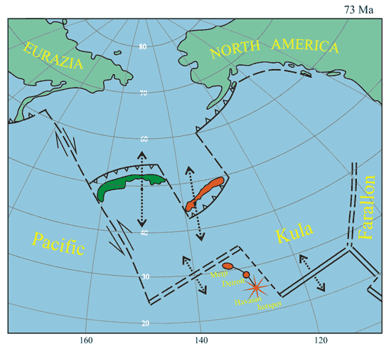
Figure 5: Northern
Pacific Ocean at 73 Ma. The Achaivayam-Valaginsky arc
is shown in dark green, and the Kronotsky-Komandorsky
arc in orange.The northernmost section of the Emperor
Seamounts, which had just started to form at 73 Ma,
was separated from Kamchatka by a complicated system
of ridges, arcs and transform faults. Although this
system was changing all the time, it existed until collision
of the Kronotsky arc with Kamchatka at ~5 Ma. Circles
with arrows correspond to paleomagnetic latitudes of
Kamchatka Isthmus in the Campanian and the Kronotsky
Peninsula in the Campanian-Maastrichtian [Levashova
et al., 2000]. See also caption of Figure 2.
43 Ma is the time at which
the Hawaii-Emperor Seamount bend formed, activity of
the hotspot essentially ceased for a while and the Kula-Pacific
Ridge ceased to exist. The Kronotsky arc became extinct
in the interval ~40-37 Ma. Since that time both the
Emperor Seamounts and the Kronotsky arc have formed
part of the Pacific plate and the distance between them
has remained constant. Interaction of the Emperor volcanic
chain with the Asian continent became possible only
after collision of the Kronotsky arc with the mainland,
and not earlier than ~10 Ma. However, this is a separate
story that does not relate to events that affected the
Emperor volcanic chain at 43 Ma.
Conclusions
Based on the overview
given above, the least contradictory hypothesis is one
where the Obruchev Rise is the first-formed of the volcanic
plateaus of the Emperor Seamounts, and it indicates
the initiation of the Hawaiian hotspot. In this case,
the Emperor Seamounts never docked with the continental
northwestern Pacific Ocean. Any rotation of the Pacific
plate must then be unrelated to local geological events
in Kamchatka.
Acknowledgements
We are grateful to Gillian
R.Foulger and Alexei Ivanov for the invitation to contribute
this paper to the website http://www.mantleplumes.org.
This work was supported by the Russian Foundation for
Basic Research, project nos. 05-05-64066, project NSH-9664.2006.5.
References
-
Bogdanov N.A., Vishnevskaya
V.S., Kepezhinskas P.K., Sukhov A.N., Fedorchuk
A.V., Geology of the Southern Koryak Highlands,
Moscow: Nauka, pp. 168, 1987. (in Russian).
-
Bragin N.Yu., Zinkevich
V.P., Lyashenko O.V., Politov A.G., Tsukanov N.V.,
Middle Cretaceous (Aptian – Turonian) deposits
in the tectonic structure of the Eastern Kamchatka,
Essays on geology of the USSR Far East.
Moscow: Nauka, 21-34, 1986. (in Russian).
-
Cabanis B., Lecolle
M., Le diagramme La/10 – Y/15 – Nb/8:
un outil pour la discrimination des series volcaniques
et la mues en evidence des processus de mélange
et/ou de contamination crustale, C.R. Acad.
Sci. Ser. II., 309, 2023-2029,
1989.
-
Creager, J.S., Scholl
D.W. et al., Initial Reports of the Deep Sea Drilling
Project,19, Washington (U.S. Government
Printing Office), pp. 913, 1973.
-
Engebretson D.C.,
Cox A., Gordon R.G., Relative motions between oceanic
and continental plates in the Pacific basin, Geol.
Soc. Amer. Special Paper, 206,
1-59, 1985.
-
Ermakov B.V., Suprunenko
O.I., Structure and conditions of formation of the
upper Cretaceous and Miocene flysch deposits of
the Koryak-Kamchatka region, Soviet geology,
12, 53-65, 1975. (in Russian).
-
Filatova N.I., Tectonic
setting of Maastrichtian – Eocene basaltic
magmatism of the northwestern sector of the Pacific
belt, Geotectonics, 4,
85-101, 1987. (in Russian).
-
-
Hourigan,
J.K., Brandon, M.T., Soloviev, A.V., Kirmasov, A.B.,
Garver, J.I., Reiners, P.W., Eocene arc-continent
collision and crustal consolidation in Kamchatka,
Russian Far East, Submitted to American Journal
of Science.
-
Khotin M.Yu., Shapiro
M.N., Ophiolites of the Kamchatsky Mys (eastern
Kamchatka): structure, composition and geodynamic
settings, Geotectonics, 4,
In press, 2006.
-
Konstantinovskaya
E.A., Margins of the east seas: tectonics, structural
evolution and geodynamic modeling, Moscow: Scientific
world, pp. 224, 2003. (in Russian).
-
Kovalenko D.V.,
Paleomagnetism of the geological complexes of Kamchatka
and southern Koryakia, Moscow: Scientific World,
pp. 255, 2003. (in Russian).
-
Kurilov D.V., New
findings of Jurassic and Cretaceous radiolarians
on western Kamchatka, In Western Kamchatka:
geological evolution in Mesozoic. Moscow: Scientific
world, 55-76, 2005. (in Russian).
-
Levashova N.M.,
Shapiro M.N., Beniamovsky V.N., Bazhenov M.L., Paleomagnetism
and geochronology of the late Cretaceous –
Paleogene island-arc complex of the Kronotsky Peninsula,
Kamchatka, Russia: kinematics implication, Tectonics,
19, 834 - 851, 2000.
-
Meschede M., A method
of discriminating between different types of mid-ocean
ridge basalts and continental tholeiites with the
Nb-Zr-Y diagram, Chemical Geology, 56,
207-218, 1986.
-
Niu Y., O’Hara
M.J, Pearce J.A., Initiation of subduction zones
as a consequens of lateral compositional buoyancy
contrast within the lithosphere: a petrological
perspective, Journal of Petrology, 44,
851-866, 2003.
-
Norton I.O. Plate
motion of the North Pacific: The 43 Ma nonevent,
Tectonics, 14, 1080-1094,
1995.
-
Rea D.K., Basov
I.A., Krissek L.A., and the Leg 145 Scientific Party,
Scientific results of drilling of the North Pacific
transect, Eds. Rea D.K., Basov I.A., Scholl D.W.,
Allan J.F., Proc. ODP Sci. Results, 145,
College Station, TX (Ocean Drilling Program), 577-596,
1995.
-
Saveliev D.P., Within-plate
alkali basalts of the Cretaceous accretionary complex
(Eastern Kamchatka), Volcanology and Seismology,
1, 14-20, 2003. (in Russian).
-
Seliverstov N.I.,
Structure of near Kamchatka sea bottoms and geodynamics
of junction of the Kurile-Kamchatka and Aleutian
island arcs, Moscow: Scientific world,
pp. 164, 1998. (in Russian).
-
Shapiro M.N., Kinematics
of the Campanian–Maastrichtian island arcs
in northeastern Asia
in light of drilling results on the Emperor Seamounts,
Geotectonics, 39, 408-415,
2005. (Simultaneous English translation from Geotektonika).
-
Shapiro M.N., Markevich
P.S., Grechin V.I., Konstantinovskaya E.A., Cretaceous-Paleogene
sandstones of Kamchatka: composition and provenance,
Lithology and Mineral Resources, 1,
36-49, 1993. (in Russian).
-
-
-
Soloviev A.V. Palechek
T.N. New data on age of the Andrianovskaya Formation
(Sredinny Range, Kamchatka): a problem of structure
of the metamorphic complexes in accretionary zones,
In: Evolution of tectonic processes in Earth
history. Moscow: GEOS, 86-89, 2004. (in Russian).
-
-
Soloviev
A.V., Shapiro M.N., Garver J.I., Shcherbinina E.A.,
Kravchenko-Berezhnoy I.R., New age data from the
Lesnaya Group: A key to understanding the timing
of arc-continent collision, Kamchatka, Russia, The
Island Arc, 11, 79-90, 2002b.
-
Sukhov A.N., Kuzmichev
A.B., Upper Cretaceous deposits of western Kamchatka.
In: Western Kamchatka: geological evolution
in Mesozoic. Moscow: Scientific world, 121-162,
2005. (in Russian).
-
Tarduno J.A., Dunkan
R.A., Scholl D.W et al., Proc ODP. Init. Repts.,
197, 2002, online at http://www-odp.tamu.edu/publications/pubs.htm.
-
Wood D.A., The application
of a Th–Hf–Ta diagram to problems of
tectomagmatic classification and to establishing
the nature of crustal contamination of basaltic
lavas of the British Tertiary volcanic province,
Earth Planet. Sci. Lett., 50,
11-30, 1980.
last updated 16th
June, 2006 |
