|
 |
Topography,
geoid and gravity anomalies in Western Mongolia |
Carole
Petit1,
Jacques
Déverchère2,
Eric
Calais3 &
Vladimir San’kov4
1
Laboratoire de Tectonique, CNRS UMR 7072,
Tour 46-0 E2, Boîte 129, 4 Place Jussieu,
75252 Paris Cedex France (carole.petit@lgs.jussieu.fr)
2 UMR 6538 Domaines Océaniques,
Université de Bretagne Occidentale
(UBO), Institut Universitaire Européen
de la Mer (IUEM), Technopôle Brest-Iroise
,Place Nicolas Copernic, F-29280 Plouzané,
France, jacdev@univ-brest.fr
3 Department of Earth and Atmospheric
Sciences, Purdue University, West Lafayette,
IN 47907-1397, USA, eric.calais@ens.fr
4 Institute of the Earth’s
Crust, SB RAS, 128 Lermontov Street, 664033
Irkutsk, Russia (sankov@crust.irk.ru)
|
This webpage is based
primarily on the work described by Petit,
C., Déverchère, J., Calais, E.,
San’kov, V. & Fairhead, D., Earth
Planet. Sci. Lett., 197,
133-149, 2002.
 Click here to
download a PDF version of this webpage Click here to
download a PDF version of this webpage
|
| Introduction:
mantle plumes, topography and gravity anomalies |
One of the proposed
manifestations of mantle plumes is uplift of the
Earth's surface that cannot be explained by other
mechanisms such as tectonic crustal thickening.
Mantle plumes are thought to generate uplift because
they:
- are made of hot, light
mantle material which is more buoyant than the
surrounding mantle,
- heat the lithosphere, and
- comprise ascending mantle which
dynamically lifts the surface.
In reality, the
effect of a mantle plume on the surface topography
is complex and depends on various factors such
as the rheological stratification of the lithosphere
(see Lithospheric Uplift
webpage) One cannot, therefore, conclude from
surface topography alone that a mantle plume beneath
is required. The support of gravity and geoid
data is of great help because they enable us to
investigate density anomalies. Bouguer gravity
anomalies are sensitive to shallow-seated anomalies,
and the geoid can detect deeper ones. In addition,
gravity can be combined with topography to calculate
isostatic anomalies and investigate the depth
of compensation of the topography.
| The
Hangai dome of Western Mongolia: general setting |
The Hangai dome
(HD) of western Mongolia is a 500 km-long topographic
bulge topped by a relatively flat, young plateau
culminating at ~4000 m (Figure 1). Active tectonics
in this region are mainly localised in the Altai
and Gobi-Altai ranges (west and south of HD) where
numerous active wrench and reverse faults have
been found (e.g., Bayasgalan et al.,1999)
. On the other hand, the HD is almost devoid of
active faults, and only a few normal faults bound
its southern flank. Thus, tectonic thickening
of the crust is unlikely to be the origin of its
elevated topography. Besides this, volcanic activity
has occurred there during the past 30 Myr, suggesting
the presence of a thermal anomaly in the upper
mantle (Windley & Allen, 1993).
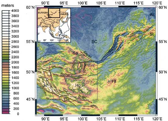
Figure 1. Topography
of the Baikal-Mongolia region (after Petit
et al., 2002). Abbreviations refer to the
main topographic ranges: Al = Altai; Go = Gobi-Altai;
Hg = Hangai; Ht = Hentai; Sa = Sayan; St = Stanovoy).
SC = Siberian craton; AL = Aldan shield. Ellipses
indicate outcrops of recent (Cenozoic) volcanism.
Solid lines correspond to active faults.
Up to now, the best-constrained
information on the vertical structure of the lithosphere
comes from thermobarometric and petrologic analyses
of young xenoliths from the Tariat (Hangai) region
(see the Mongolia
webpage of Barry et al., 2005; Ionov
et al., 1998; Kopylova et al., 1995)
and can be summarised as follows:
-
the average
crustal thickness is ~ 45 km in western Mongolia;
-
the maximum
crustal thickness (50 ± 3 km) occurs
beneath the northern Hangai area, where pressure
equilibration conditions deduced from the
shallowest ultramafic rocks are ~ 1.4 x 10³
MPa;
-
the lithosphere
– asthenosphere transition is likely
to occur at depths greater than 70 km, as
indicated by an upper mantle xenolith geotherm
(Ionov, 1998);
-
around 40-50
km depth, xenolith equilibration temperatures
suggest a steep geotherm which cannot result
from heat conduction alone, and could suggest
heat advection from basaltic intrusions and
underplated cumulates near the Moho. Except
in some places such as the Hovsgol graben,
the average heat flow in Mongolia is moderate
(~60 mW m-2), which does not support
the hypothesis of large-scale thinning and
heating of the lithosphere.
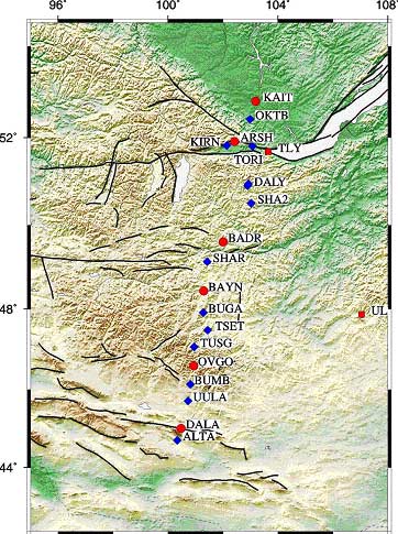 |
Until recently, crustal seismic data
were lacking in Mongolia. However, a
seismic experiment was conducted in 2003
with 20 stations crossing Western Mongolia
in a NS direction from the Gobi-Altay
range to the Siberian craton (Figure
2). The results will provide crucial
constraints on crust and upper mantle
structure and are expected in 2006. Global
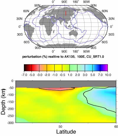
and regional tomography models in Asia
have consistently imaged a deep-seated
(around and below 100 km) low-velocity
anomaly beneath central Mongolia (e.g., Curtis et al.,
1998; Petit
et al.,
1998; Ritzwoller & Levshin,
1998). The shear-wave velocity model obtained
by Villasenor et al. (2001) from
inversion of surface wave velocities further
strengthens this view: it depicts a large
low-velocity anomaly beneath the Hangai-Hovsgol
region at about 100 km depth, with a –4%
contour line fitting approximately the
broad uplands of Hangai and Hovsgol, whereas
no anomaly is found below Lake Baikal.
The surface projection of the Hangai-Hovsgol
shear-wave velocity anomaly correlates
quite well with widespread volcanic emissions
dated between Paleogene and Quaternary.
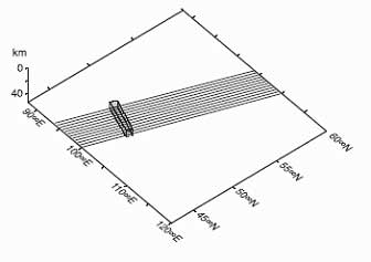
Figure 2. Location of the 20 seismic
stations of the 2003 MOBAL seismic experiment.
|
| Gravity,
isostatic anomalies and the geoid |
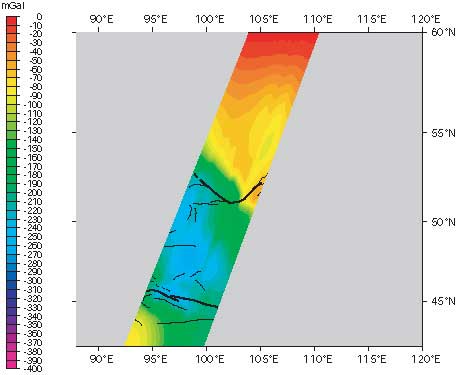
The Bouguer gravity
anomaly is, on average, much lower in Western
Mongolia than in the Baikal region (Figure 3).
A greater crustal thickness and/or a thinner lithosphere
are possible explanations for this observation.
Isostatic anomalies show large minima over western
Mongolia, indicating mass deficits with respect
to a local, Airy-type compenstated situation (Figure
4). Some of these minima, for instance along the
Altai and Gobi-Altai ranges, closely follow the
pattern of active faults and could reflect tectonic
crustal thickening, which is consistent with field
observations (Figure 4a). However, the Hangai
dome and its northern prolongation, the Hovsgol
dome, are associated with a wide, oval-shaped
negative anomaly of much larger wavelength (Figure
4b). This anomaly correlates well with the region
of low velocity imaged by seismic tomography models
(Figure 5), and also with higher-than-average
(70-80 mW/m2) surface heat flow (Khutorskoy
& Yarmoluk, 1989).
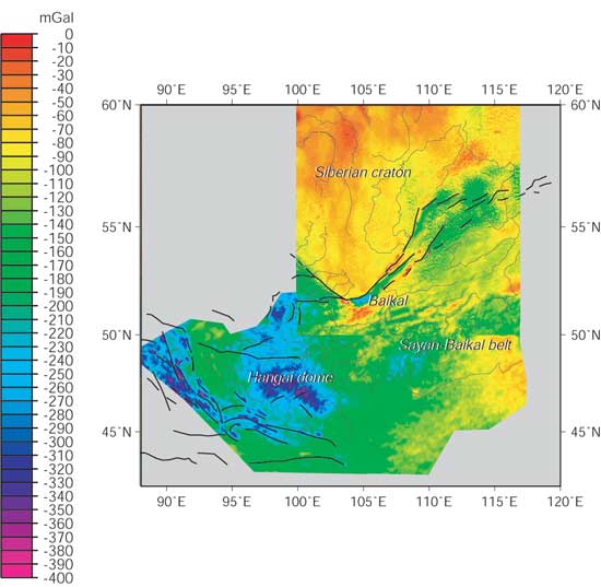 Figure 3. Bouguer
gravity
Figure 3. Bouguer
gravity |
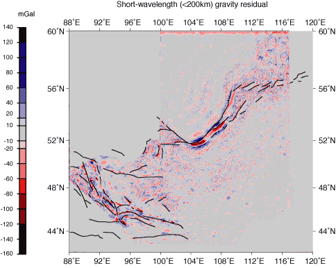
Figure 4a. Short-wavelength
isostatic anomalies
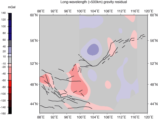
Figure 4b. Long-wavelength
isostatic anomalies
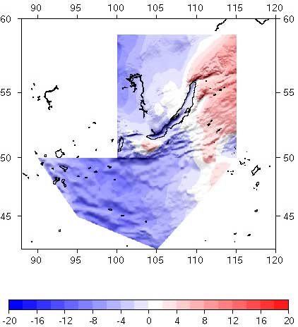
Geoid anomalies
over Mongolia are negative, indicating
a mass deficit in the lithosphere or upper
asthenosphere (Figure 6). In the “classical”
mantle plume model, dynamic effects overcome
the density deficit expected from rising,
low-density material, such that positive
geoid anomalies are expected (the Iceland
region is an often-quoted example of this.
See also webpages on Iceland).
This is clearly not the case here, and
instead the evidence is more consistent
with a low-flux plume or simple “static” thermal
anomaly in the lithosphere as advocated
by Barry et al.,
2005.
Figure
6. Geoid height in meters |
 |
(a) |
Three-dimensional
forward modelling of the gravity and topography
provides additional information on the mass
deficit and may be compared with other,
independent data e.g., from mantle
xenoliths and seismic tomography. A slightly
lighter (–10 kg/m3) upper
mantle extending from 100 to 200 km can
explain the long-wavelength gravity and
isostatic anomaly extending from Hangai
to Hovsgol. A deeply-rooted plume is not
required (Figure 7a).
Locally, magmatic
underplating beneath the crust could explain
the larger mass deficit beneath the apex
of the dome (Figures 7b and 8). We modelled
the “excess” topography (with
respect to the mean altitude related to
the average crustal thickness) resulting
from isostatic compensation of these anomalies
using the Paravoz finite-element code (Figure
9, and Lithospheric
Uplift webpage). Whereas the deep lithospheric
anomaly can explain the long-wavelength,
~500 m-high topography excess encountered
over Hangai and Hovsgol, the lower crustal
anomaly can account for the additional 700
m found at the top of the Hangai dome itself.
North and
south of the profile, the high mountains
of Sayan and Bogd (Figure 1) are not reproduced
by this model, but are likely to result
from tectonic thickening of the crust, which
is consistent with field observations of
strike-slip and thrust faulting (e.g.,
Bayasgalan et al., 1999).
|
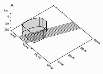
(b)
Figure 7. 3D shape of
the polygons representing (a) the deep-seated
and (b) the lower crustal density anomalies,
of –10 kg/m3 and –200
kg/m3, respectively. |
Figure
8. Synthetic Bouguer gravity produced by
the two modelled density anomalies and localised
fault flexure (north and south of the dome). |
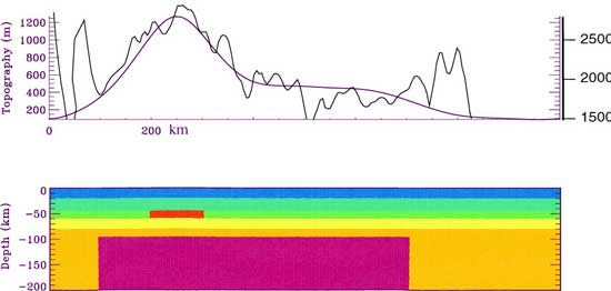
Figure 9. Isostatic
topography (top, smooth, purple line) due to the
2 modelled density anomalies (bottom, in red and
purple) compared to the observed (top, irregular,
solid line) sampled along a S-N profile. Topography
is computed using the Paravoz finite element code
(see Lithospheric Uplift
webpage and references therein)
Gravity and topographic
data, combined with other constraints on crustal
and mantle structure such as seismic tomography
and analyses of mantle xenoliths, do not provide
evidence for a high-flux plume (or “hot
spot”) beneath Mongolia. A model that fits
the observations better is one involving a shallow
(100-200 km) density deficit which isostatically
supports part of the excess topography (with respect
to the average crustal thickness) encountered
there. This is in agreement with the petrology
and geochemistry of the basalts which suggest
a low-flux thermal anomaly located in the lower
lithosphere or upper asthenosphere, as suggested
by Barry et al. (2005).
These authors point out that long-lived, scattered
volcanism has occurred in Asia for ~30 Ma with
similar chemical characteristics, suggesting a
common origin for Mongolian, Chinese, and Baikal
basalts. Its cause is still enigmatic, but could
reside in large thermal perturbations in the Asian
mantle that result from Pacific and Indian subduction
(see also the Plate
Tectonic Processes webpage). |
|
References
-
Bayasgalan,
A., J. Jackson, J.F. Ritz, S. Carretier, 'Forebergs',
flower structures, and the development of
large intra-continental strike-slip faults:
The Gurvan Bogd fault system in Mongolia,
J. Struct. Geol., 21,
1285-1302, 1999.
-
Cunningham,
W.D., Cenozoic normal faulting and regional
doming in the southern Hangay region, central
Mongolia: implications for the origin of the
Baikal rift province, Tectonophysics,
331, 389-411, 2001.
-
Curtis,
A., J. Trampert, R. Snieder, B. Dost, Eurasian
fundamental mode surface wave phase velocities
and their relationship with tectonic structures,
J. Geophys. Res., 103,
26919-26947, 1998.
-
Ionov,
D.A., S.Y. O'Reilly, W.L. Griffin, A geotherm
and lithospheric section for central Mongolia
(Tariat region), in: M.F. Flower, S.L. Chung,
C.H. Lo, T.Y. Lee (Eds.), Mantle Dynamics
and Plate Interactions in East Asia,
AGU Geodynamics Series 27, 127-153, 1998.
-
Khutorskoy,
M.D, V.V. Yarmoluk, Heat flow, structure and
evolution of the lithosphere of Mongolia,
Tectonophysics, 164,
315-322, 1989.
-
Kopylova,
M.G., S.Y. O'Reilly, Y.S. Genshaft, Thermal
state of the lithosphere beneath central Mongolia:
evidence from deep-seated xenoliths from the
Shavarym-Saram volcanic center in the Tariat
depression, Hangai, Mongolia, Lithos,
36, 243-255, 1995.
-
-
Petit,
C., Déverchère, J., Calais,
E., San’kov, V., and Fairhead, D., Deep
structure and mechanical behavior of the lithosphere
in the Hangai-Hovsgol region, Mongolia: new
constraints from gravity modeling, Earth
Planet. Sci. Lett., 197,
133-149, 2002.
-
Ritzwoller,
M.H., A.L. Levshin, Eurasian surface wave
tomography: group velocities, J. Geophys.
Res., 103, 4839-4878,
1998.
-
Villaseñor,
M.H. Ritzwoller, A.L. Levshin, M.P. Barmin,
E.R. Engdahl, W. Spakman, J. Trampert, Shear
velocity structure of central Eurasia from
inversion of surface wave velocities, Phys.
Earth Planet. Inter., 123,
169-184, 2001.
-
Windley,
B.F., M.B. Allen, Mongolian Plateau: Evidence
for a late Cenozoic mantle plume under central
Asia, Geology, 21,
295-298, 1993.
|
last updated
19th October, 2005 |
|
|
|